Fiat lux. Often sourced from its mention in the Book of Genesis, meaning “Let there be Light.”
Cedar Falls, Iowa is home to the University of Northern Iowa, whose motto is simply “Lux,” or “light.” This nearly 150-year-old bastion of learning is both Cedar Falls’ largest employer and the primary source of its population growth over the past several decades. One resulting effect of this growth was the unfortunate circumstance of the University Avenue corridor, which was originally designed and constructed in the 1960s to meet the then-meetable needs of the community, no longer serving as a viable or equitable means of mobility. As Cedar Falls is what you would commonly call a college town, mobility throughout the city is not primarily vehicular, but is a more diverse salad of standard traffic mixed with pedestrians, public transit services, bicyclists, mopeds, scooters, and so forth. The location of University Avenue—an urban arterial that was at one point the sole connection between the city and the neighboring (and thrice larger) city of Waterloo—makes it a crucial throughway, even in the face of alternative routes which have cropped up in the intervening years. In the middle of the last decade, it became abundantly clear that it was time for this roadway to be given a new breath of life, to be seen in new light—and that process began, as many such processes often do, with the local community.
A needed arrangement
While there were a number of players and stakeholders involved in what would become the three-phase, $38.9 million University Avenue Reconstruction Project, an initial wrinkle nearly derailed everything before an estimation of need could even be formulated.
As an urban arterial, University Avenue fell under the jurisdiction of the Iowa DOT (IDOT), whose cadre of roadways made the needs of this particular road middle-of-the-pack, at best. The urgency for its reconstruction was not a matter of state-level evaluation, but the persistent push of local leaders and business owners.
“University Avenue was built to be a very vehicle-centric, high-speed corridor,” Aaron Moniza, senior client manager for Foth Infrastructure & Environment LLC, told Roads & Bridges. “Over time, however, it transitioned to more local functionality. So one of the big challenges was how to reimagine the road to better serve the traffic volumes and purposes required by the community now, as opposed to what it was initially designed for.”
Foth, as designer on the project, stepped onto a roadway riddled with significant issues—but they also landed amidst a cacophony of local voices eager for them to fulfill their purpose.
“The pavement condition really necessitated the sense of urgency,” Moniza recalled. “Being over 60 years old, it had really fallen into a state of absolute deterioration in some places, to the point where, when we did early pavement cores, the pavement literally crumbled in our hands. The city of Cedar Falls had been receiving numerous complaints from residents about its condition, and thankfully that community pressure got the city to take ownership of the road from IDOT, which spurred some action.”
The transfer of ownership from IDOT to the city resulted in a shorter communication string, effectively allowing resident perspective and feedback to directly reach project planners, as well as the new owner, with greater speed than would otherwise have been the case. Moreover, the negotiated payment from IDOT to the city, which occurred in a lump sum upon transfer of ownership in August 2014, helped pay for a significant portion of the project, the remainder of funding coming from the city itself through local taxes and various other funding mechanisms.
As Foth and the city of Cedar Falls entered into partnership, the vision was set to create a new transportation plan that would, in one fell swoop, calm traffic, reduce travel times, improve safety, support a “living street,” and be compatible with the existing road network.
A clarity of vision
“One of the requests of the city was to accelerate the entire project from development through construction,” Moniza said. “We cut the normal timeframe in half, particularly on the upfront work—the conceptual design, the public involvement and right-of-way negotiation, and the final design.”
When you take an urban arterial such as University Avenue and work on it in an accelerated manner, the main challenge becomes balancing speed with the public involvement element. Speed, after all, costs money. Fortunately, the city was amenable to the cost implications of accelerated design and construction, in effort to reduce day-to-day impacts on the road and its 20,000 daily vehicles.
“Another request the city had was to maintain both through traffic and full access to all businesses located throughout the project site,” Blaine Buenger, Foth’s senior technology manager, told Roads & Bridges. “Striving to find the delicate balance between providing access and constructing as quickly as we could was the trick.”
A further “must” handed down by the city was to bring multimodal elements to the area. The existing corridor had none to speak of at all.
“No pedestrian or bicycle facilities,” Moniza confirmed. “One of the perceptions we worked to overcome with the public was that very topic.”
A solution in design would placate public concerns, while creating a living model of the project overall, one that would source from multiple data points and also be able to adapt to the continual addition of real-time data so that all stakeholders, from design to those with boots in the dirt, could work from a single source of truth.
Sounds easy, but it wasn’t
Though project planners devised a strong strategy for meeting the requirements of the city-owner, a plethora of obstacles made a minor hash of things anyway. A Cedar Falls mayoral election caused a regime change mid-project, necessitating that planners get a new administration plugged into the project. And there was an unsilent, stubborn local minority unsure of the plan being put into action. Not to mention numerous adjacent businesses, all needing to stay open and accessible, and expected but nonetheless tough utility concerns.
The guiding light through this obstacle course was the 3-D model created of the entire project site by Foth.
“We had a library of historical information that was collected very early on,” Buenger said. “As-builts, traffic data, information on existing utilities. We combined that data with LiDAR data we got from the city and incorporated it into our survey information. We combined a number of different survey tools to collect data—traditional survey, mobile-scans of the corridor, drone captures. This all served as the foundation of the 3-D model.”
Using a suite of Bentley Systems’ design tools—including OpenRoads, ProjectWise, LumenRT, and others—designers worked with 21,619 files and more than 120 gigs of data, which were dispersed over six offices across the U.S. The ProjectWise interface helped the remote management of data and provided an audit trail for design changes, which quickly enabled them to diagnose the root cause of a conflict—when and where it occured—in order to remediate the issue in just hours.
Foth provided three alternative designs to the city, employing cost-effectiveness analysis as a valuation of travel time (which was one of the city’s primary concerns from the beginning); this resulted in the eventually chosen design, which won out due to its ability to improve traffic flow and safety, reduce serious and fatal crashes, cut traffic delays, and eliminate stops and the long vehicle queues they cause, all while cutting estimated fuel consumption and emissions.
“We felt this design was the best choice,” Moniza said. “The city laid out its list of priorities, and this best met those stated needs.”
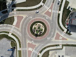
The problem, from the point of view of the aforementioned vocal minority of residents, was the design called for roundabouts—a mobility solution that had, until then, not been seen in that part of the state.
“There were folks concerned about the roundabouts,” Moniza said. “More than we anticipated. In fact, this is what required the most substantial public education campaign on the project. We did a number of animations and visualizations to help the public ‘see’ the planned improvements. Most of us can attest to the fact that the ability to really show your ideas is incredibly powerful in this day and age. That was certainly the case here. It was, in fact, absolutely critical to being able to facilitate the project. I mean, we had just a litany of questions answered in this way.”
“Roundabouts are a fairly new concept in northeastern Iowa,” Buenger agreed. “There’s not a lot of them, and the comfort level isn’t there. A lot of our public outreach centered around ‘how do I navigate a roundabout’ and the models came in useful in that respect. We even built a simulation at a public library, and another in a parking lot, so folks could walk around it and see for themselves.”
This winning concept, which transformed the six traditional traffic signals in the 2-mile project zone into roundabouts will deliver an estimated ROI to the city of $32 million over the next 25 years in the form of reductions to traffic signal maintenance ($51,000 per annum), travel time cost savings ($1.1 million per annum), cuts in gas use ($23,000 per annum), and vehicle emissions ($4,173 per annum), as well as more than $4 million in overall savings due to reduced crash incidents. The multimodal improvements provided 26 designated pedestrian crossings and 4 miles of new sidewalk and trail—which gave new connections to 31% of the low-income residents living near the corridor.
As to the complication brought on by utilities, Iowa is, in this regard, no different, Moniza said, than anyplace else: “We had 11 different public and private utility companies located in this corridor, including the city system (water, sanitation), gas company, and a few major private communications utilities. Over 200 utility conflicts. The coordination process was one of the first things we started, and it carried all the way through the end of construction. An element of the 3-D model that helped immensely was in utility coordination. We had a private communications utility that had a facility located along the corridor. We worked very closely with them to identify their conflicts, namely where their facility had to be relocated versus troubling with workarounds. The 3-D model was essential in working through that process.”
Put people first, the rest falls into place
Construction of the project was let in three phases. Phase 1, contracted to R.K. Cunningham, comprised a 1-mile stretch of University Avenue from Hwy. 58 to the Waterloo Road intersection. Phases 2 and 3—both won by Peterson Contractors Inc. (PCI)—consisted of, respectively, Waterloo Road east to Midway Drive at the Cedar Falls city limits, and the interchange at University Avenue and Hwy. 58.
Chris Fleshner, project estimator and manager for PCI, which also served as a sub-contractor on Phase 1 work, told Roads & Bridges that despite the challenge of keeping on top of the most current version of the 3-D model, it was nonetheless of particular importance during construction: “The biggest value for us was not having to wait for survey data or updates during construction. We use automated controls on our equipment, and with up-to-date information, we could operate and grade correctly.”
By employing a central concept to the accuracy and efficiency of the design process through the use of a single 3-D model, project planners and crews were able to successfully give to the city the full reconstruction of 2 miles of urban corridor, a new interchange, seven controlled intersections, a raised landscape median, pedestrian trails, stormwater management facilities, new or relocated public and private utilities, and access management. The focus on people, on the lives and economy created by their work, made this more than just a new road project. The advent of this novel “living street” is now a guiding light for the future of the city, one that will experience expansion and a deepening of tradition in equal measure.


