Horry County, South Carolina employs data system to manage a rapidly growing paved road network

Horry County is located on the coast in northeastern South Carolina.
Home to Myrtle Beach and the Grand Strand, the area accommodates approximately 15-19 million visitors annually. As with most areas in the coastal southeast, Horry County continues to experience a prolonged period of unprecedented growth; it is the population center of the second-fastest growing metropolitan area in the country, according to the most recent U.S. Census Bureau population estimates—28% population increase from 2010-2018 and a 3.8% increase from 2017-2018 alone. As Horry County continues to adapt to accommodate record numbers of visitors and new permanent residents, the management of the local transportation network likewise needs to adapt to handle the continued growth of the paved road system.
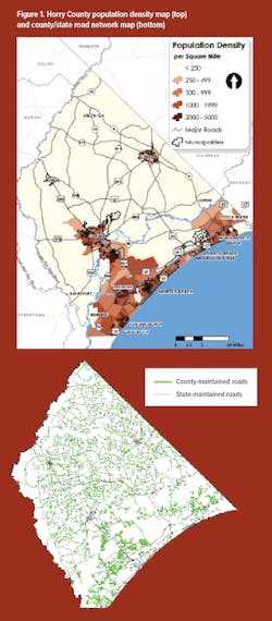
The Horry County Engineering Department is responsible for the pavement management system of the local road network in the unincorporated areas of the county, which is home to over 260,000 permanent residents, or about 75% of the total population in the county. Horry County is the largest county by land area in South Carolina at over 1,133 sq miles, which is about the same size as the entire state of Rhode Island. With such a large “local” geographic area, it follows that the county’s local road network varies greatly in character, ranging from four and five-lane urban/suburban arterials with daily traffic volumes approaching 30,000 vehicles per day in the heavily developed areas near the coast to hundreds of miles of dirt roads, with only a handful of trips per day in the most rural inland areas (Figure 1).
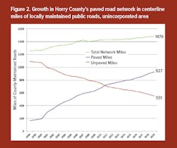
Nonetheless, the paved local road network in unincorporated Horry County has more than doubled in the last 15 years (Figure 2), and it continues to grow at a rapid pace, adding about 25-30 new centerline miles per year. The fast growth of the county’s paved road network stems from two primary sources: capital projects that pave existing county-maintained dirt roads (15 miles per year on average) and the acceptance of new public roads associated with new residential and commercial development (about 10-15 miles per year). The county now has over 927 miles of paved roads, and it is expected to eclipse 1,000 centerline miles within the next few years, if recent trends continue.
Making the case
Prior to 2007, the county’s annual budget for paved road maintenance and resurfacing was less than $1 million. A $10 increase to the annual road maintenance fee (from $20 to $30) was approved by the County Council that year, and this grew the annual resurfacing budget at that time to approximately $2 million. The county’s annual road maintenance fee is paid by the owners of motor vehicles registered in Horry County; the fee is applied to each registered vehicle. Faced with the rapid growth of the paved road network and the inevitable “tidal wave” of unfunded road maintenance needs in the near future when the newly paved and accepted roads approach the end of their service life, county staff approached the Horry County Council in early 2015 about increasing the road maintenance fee to cover the projected expenses of maintaining the growing paved road network.
Ultimately, the county council approved a 67% increase in the annual road maintenance fee to $50 for each registered vehicle for FY 2016, and this increased the county’s annual resurfacing budget at that time from approximately $3 million to nearly $7 million. The use of the data generated from MicroPAVER (PAVER) was an invaluable part of the county staff’s presentations to officials to educate them about the forthcoming road maintenance funding shortfall, and it was needed to convince them to approve an increase in the road maintenance fee.
The Horry County Engineering Department has used PAVER since 2009 to manage to the county’s paved road network by prioritizing roads for the annual resurfacing program. This is accomplished by conducting periodic road assessments on all paved county-maintained roads on a rolling basis. The target assessment cycle for each road is 3-4 years. Horry County’s primary strategy for paved road maintenance involves typical mill and overlay (approximately 1.5 in.) with limited wide-scale preventative maintenance work, such as full-depth spot repairs completed prior to resurfacing, as needed (100% road coverage of crack seal, slurry, microsurfacing, and similar treatments have not proven to be beneficial in the long-term).
All paved road sections under the county’s jurisdiction have a specific segment number assigned to the road for use in PAVER. The data that the engineering department collects on each road segment for input into PAVER includes the following: pavement conditions (distresses with measurements), road classification, road lengths and widths, year of initial paving, and year of last major work (resurfacing). Other user-defined fields include pavement markings and conditions, average daily traffic data, guardrail, county council districts, sidewalks, curb and gutter roads (concrete), paved valley swale (asphalt gutter), grass shoulder roads (no gutter), right-of-way, speed humps, and subdivision names. A side benefit of using PAVER to help manage the county’s paved road network is the user-defined fields that help staff track the condition of pavement markings, which allows reports to be generated to select roads with poor pavement marking conditions for restriping on the county’s pavement marking contract.
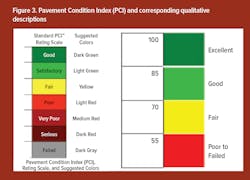
After a road segment is evaluated by county staff and the pavement distresses are keyed into PAVER, a Pavement Condition Index (PCI) number is calculated for each road segment (Figure 3). The PCI number allows the engineering department to prioritize roads for a constrained budget of only resurfacing 30 miles of roadway each year.
The ability of adding the user-defined fields also allows reports to be generated with only the fields that are needed. Reports of distresses for each road can be chosen and given to the Public Works Department to help identify roads for patching and repair prior to resurfacing. Reports are generated from PAVER to assist in the engineering department’s resurfacing contracts to help identify roads that have a low PCI.
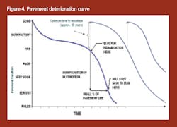
The county’s routine pavement evaluations allow pavement deterioration curves to be used by PAVER in prediction modeling after a given segment of road is evaluated a minimum of three times and the patterns of distress and the age of the pavement are analyzed by the software. The pavement deterioration curves used by PAVER may be different for each “family” of roads, but will be similar to the curve shown in Figure 4. Horry County groups segments of road into “families” based on common functional class and other road characteristics (curb and gutter, shoulders, etc.) for use by PAVER’s prediction modeling algorithms to generate an estimated road segment’s PCI for any point in the future.
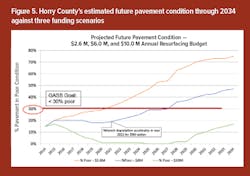
The future PCI data generated by PAVER’s prediction modeling function was key in obtaining county council approval for additional road maintenance funding to help the county cope with the growing paved road network. Different regions of the country have different standards for what passes as an “acceptable” pavement condition; the PCI data generated from PAVER allows for this variation because a specific numeric PCI value can correspond to different qualitative descriptions of the pavement network (excellent, good, fair, poor, etc.) as shown in Figure 3. Horry County staff used these qualitative descriptions of the pavement network and the future PCI data generated from PAVER to calculate the percentage of network miles that would be considered as being in “poor” condition for the next 20 years, and this same calculation was done under three different funding scenarios in PAVER. The results of this analysis were summarized on a graph that was presented to the county council to communicate the future condition of the county’s road network without a funding increase and under two different levels of assumed funding increases (Figure 5). This single graph succinctly brought home the point that additional funding would be needed to maintain the integrity of the county’s paved road network, and it was integral to achieving a significant budget increase for FY 2016 to approximately $7 million.
Today
Fast forward from the success story in 2016, and Horry County’s current resurfacing budget (for 2019 and 2020) has decreased by nearly $2 million, because a sizeable portion of the road maintenance fee was deemed to be a legal and acceptable revenue source that could help fund a recurring shortfall in the local public transit agency’s budget. This funding cut has occurred despite continued paved road network growth and increasing road resurfacing and asphalt costs. So the county is now facing what many municipalities, cities, and counties across the U.S. are facing—the need to do more with less. Yet even with the recently reduced annual resurfacing budget, Horry County’s paved road network and future outlook is in better shape today than it was in the early 2010s, prior to the most recent fee increase. Horry County staff continues to use PAVER to prioritize its roadway resurfacing program and to generate PCI data under future funding scenarios as it will be needed to convince elected officials that a revenue increase or new funding source will be needed once again, so that the ever-booming county does not fall farther behind the pavement maintenance curve.