Reinventing Bridge Surveys
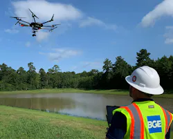
The Texas Department of Transportation (TxDOT) saved somewhere between $54-$60 million in reconstruction costs on a road-widening project thanks to a 3D model. Delivered in days instead of months, the model was the result of a coordinated aerial, vehicle and boat-mounted LiDAR system for a waterway bridge survey.
The Collin County project — FM 3286 (E. Lucas Road) reconstruction at Lake Lavon, which is scheduled to be completed in 2028 — received national recognition for setting a new precedent in surveying and mapping technology applications.
At first glance, widening a rural two-lane road sounds straightforward. However, this roadway carries more than just local traffic. It links growing communities as one of the few east-west connections across a 21,400-acre lake that supplies water for hundreds of thousands of residents in north Texas. Commuters, school buses and emergency services traverse this corridor where congestion and accidents had become an increasing concern.
When TxDOT’s Dallas District set out to reconstruct and expand the corridor into a six-lane divided arterial with shared-use paths, two bridges spanning Lavon Lake required a novel approach to future proof this critical transportation infrastructure. One bridge stretches nearly 1,500 feet total and the other more than a mile. Redesigning these critical crossings required precise engineering.
Before any design could advance, TxDOT needed data documenting the existing structures, particularly the substructures hidden beneath the bridge decks. Traditionally, that level of detail would require months of lane closures, expensive equipment suspended over bridge decks and crews working dangerously close to live traffic.
BGE’s survey team set out to resolve this challenge by combining three LiDAR platforms—aerial, vehicle-mounted and a bold adaptation using a boat-mounted system—into a single integrated dataset.
Bridging the Gap: An Out of the Box Technique
Aerial LiDAR, flown by a manned fixed-wing Distributed Aperture System (DAS) aircraft, captured the big picture corridor view from above. Vehicle-mounted mobile LiDAR then scanned the bridge decks at speed, collecting millions of points per second with extraordinary accuracy. The third variation of a vehicle system involved deploying LiDAR from a vessel to capture substructure data beneath the bridges.
This boat-mounted LiDAR was a breakthrough. Mounting a million-dollar scanning unit, complete with inertial guidance system, commonly used for missile guidance, onto a vessel meant recalibrating for pitch, roll, and yaw at every pass.
The three data sources were tied together using control points on the roadway, bridge walls and other identifiable features. Once registered, the combined dataset allowed the mapping team to produce true 3D models of bents, columns, girders and bridge walls. Pioneering a tri-source LiDAR approach for TxDOT, the solution provided unprecedented clarity into existing conditions.
Instead of 2D lines with elevations, TxDOT received data-rich deliverables—true 3D models that could be rotated, examined from every angle and trusted for accuracy. This approach helped ensure the design would meet 100-year floodplain requirements, giving confidence in the bridges’ resiliency long into the future.
Engineering Complexity
Behind the clean lines of a 3D model lies extraordinary technical complexity. Mounting such a system on a vessel meant overcoming specific challenges around calibration, stability and registration. The LiDAR units captured up to 2.5 million points per second, and even small misalignments between datasets could place the same structural element feet apart in the merged point cloud.
Data processing was equally demanding. The design engineering team relied on specialized processing software and high-powered workstations to clean, filter and align the aerial, vehicle and vessel data, transforming raw point clouds into accurate, navigable 3D solids.
The project’s location introduced another layer of difficulty. Because the bridges cross U.S. Army Corps of Engineers property (federal land), all work had to remain within existing easements. Any request for new easements would have triggered extensive coordination and added cost. An entirely new road crossing would have required an act of Congress. That constraint elevated the importance of the survey itself: by widening the existing bridge and proposing a new adjacent structure, TxDOT could stay within its right-of-way while minimizing disruption.
Sustainable Design Considerations and Flood Resiliency
Because the survey confirmed widening existing bridges and adding a new structure alongside them, rather than rebuilding nearly 7,000 feet of bridge from scratch, TxDOT avoided an estimated $54-$60 million in reconstruction costs. Preserving the existing structures also reduced material waste and minimized the project’s overall environmental footprint.
In addition to cost reduction, a survey of this kind has ripple effects that extend to public safety. Unlike conventional approaches that require extended field presence and lane closures, this method supported work mostly done from the air, from a vehicle and vessel and via in-office data processing. By avoiding extended detours, dangerous fieldwork and other traffic hazards, the team protected motorists and workers while sparing residents from months of delays and construction impacts.
One of the most important outcomes of the LiDAR survey was its ability to provide accurate elevation data critical to addressing flood risks. Lavon Lake is regulated by a dam, and the bridges must maintain clearance above the reservoir’s high-water mark even during major storm events. By precisely documenting the elevations of bridge decks, substructures and surrounding conditions, the survey enabled engineers to verify compliance with TxDOT’s flood criteria and 100-year flood requirements, an increasingly vital assurance as north Texas faces more severe weather and flooding.
Robust 3D Data
Multi-platform LiDAR is increasingly recognized across the AEC industry as the most efficient path to high-fidelity as-built documentation. Engineers and surveyors can now think beyond traditional methods to survey complex water crossings using tri-source LiDAR systems that not only accelerate schedules but also help the industry improve safety and design for long-term flood resiliency.
Without actionable data in civil engineering, engineers have had to rely on data models and assumptions, risking costly changes later in design. With it, they can redefine what’s possible in surveying and mapping technology—saving millions, safeguarding the public and setting a precedent for projects nationwide.
Rene Silvas is a senior director of Surveying at BGE, Inc. and Scott Osterhoudt is director of land surveying at BGE, Inc.