Avoiding Work Zone Danger: Why AVs Need Thermal Imaging
Autonomous vehicles (AVs) are appearing on roadways at an accelerating rate and demonstrating their ability to navigate common highway scenarios. A considerable challenge remains, however: safely handling “corner cases”—unusual but real situations that drivers encounter on the road. These cases often include safely navigating construction zones.
According to the Federal Highway Administration's 2026 National Work Zone Awareness Week factsheet, 850 people were killed in U.S. work zones in 2024, the latest data available. This represents at least two deaths every day on average. According to the same factsheet, rear-end collisions accounted for 22% of fatal work zone crashes that year, and speeding was a factor in more than a third of them.
While highway safety measures have evolved, speed-related fatalities in work zones increased between 2023 and 2024, as noted in the same Federal Highway Administration Work Zone factsheet. Sudden congestion, lane shifts, and lane compression required for road work all leave little margin for error. Temporary work zone speed limits and doubled fines are designed to protect workers, pedestrians, and drivers. While studies have shown that drivers tend to slow down in posted work zones, that decrease doesn’t usually reflect the actual posted work zone speed limit, greatly increasing the risk to themselves, other drivers, and workers. The reality is that roadside jobsites are high-risk environments.
Like Humans, Vehicles Can Be Blinded
Unlike established highway segments with consistent lane markings and permanent structures, construction zones rely on temporary signage and traffic patterns that vary by state, project scope, and site. This variability can create dangerous conditions because autonomous sensor stacks rely heavily on learned patterns to identify hazards. Those patterns may break down when systems encounter temporary lane shifts, new or nonstandard signs, and faded or missing road markings. Dust, fog, glare, smoke, and rain can compound the challenge.
The challenge becomes even greater at night and in other low-visibility conditions. Standard headlights typically illuminate only about 60 meters ahead on low beam and 150 meters on high beam on straight roads, creating a hazardous perception gap. More than half of all fatal work zone crashes occurred after dark in 2024.
Nighttime construction zones often use high-intensity floodlights and high-visibility clothing to improve visibility. Although these measures help human drivers, glare can wash out visible-light cameras and effectively blind a vehicle’s primary optical sensors in a high-risk setting. Construction zones can also be crowded with vehicles, workers, equipment, and signage, potentially reducing the effectiveness of LiDAR sensors.
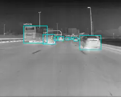
In short, visible-light cameras, radar, and LiDAR cannot always provide the full range of information needed to navigate a work zone reliably. Addressing the challenge requires diverse sensors and robust sensor fusion, including thermal imaging to improve perception in low-visibility conditions, especially at night.
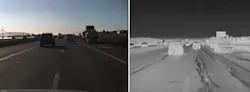
Thermal cameras detect heat signatures rather than visible light, making them well suited to address the risks created by floodlight glare, darkness, dust, and visually cluttered environments. Paired with machine-learning models trained to identify pedestrians, cyclists, vehicles, and other roadway objects, thermal imaging can help distinguish a worker or concrete barrier from the surrounding environment at long range and in inclement weather. Several major truck manufacturers and OEMs are already integrating thermal sensors into advanced driver assistance system (ADAS) perception stacks.
Sensor Stacks are the Baseline
Despite significant advances in autonomous vehicle and ADAS technologies and regulations, no single codified national standard governs how AVs should operate in work zones. State approaches to AV regulation vary widely, making it difficult to point to one settled framework for work zone safety. This variation also creates inconsistency for AV systems traveling across state lines.
State departments of transportation (DOTs) also often lack the digital infrastructure needed to manage changing work environments at scale. Large cities can issue many construction-related street permits in a single day, making manual inspection of every active work zone impractical. A digital permitting layer that feeds real-time work zone data into autonomous mapping networks could help close that gap. Research partnerships such as the collaboration among the University of Cincinnati, the Ohio Department of Transportation, and Honda to study how ADAS should recognize and respond to hazards are an important step toward establishing such standards.
For widespread vehicle automation to scale safely, reliable work zone navigation must become a baseline capability. It will require systems that can safely navigate the unpredictability of active construction zones. By combining better digital infrastructure with greater sensor diversity, particularly thermal imaging within the sensor-fusion perception stack, the industry can better protect workers and road users in and around work zones.
Chris Posch is currently the Director of Emerging Product Management at Teledyne FLIR OEM.