How Caltrans Streamlines Pavement Management
California's state highway system is a complex transportation network with over 50,000 lane miles that require constant monitoring and maintenance. With California’s Department of Transportation (Caltrans) managing approximately $16 billion in active projects, the agency faces an ongoing challenge: how to efficiently assess pavement conditions across this extensive network while keeping inspection crews safe and costs manageable.
The answer lies in technological capabilities that are reshaping infrastructure management.
Mobile mapping systems enable crews to collect many miles of georeferenced LiDAR and imaging data daily. Algorithms based on machine learning (ML) then analyze this data to automatically assess pavement conditions, resulting in efficiency gains, safety improvements and cost savings.
Caltrans’ implementation of this technology demonstrates how transportation agencies can leverage ML and mobile mapping data to fundamentally alter their approach to pavement management.
Low Tech to High Tech
The contrast between traditional and ML-powered pavement inspection methods is striking. Conventional inspections require trained personnel to manually survey pavement sections, requiring weeks or months to cover large networks at a walking pace. Allocation studies conducted by the U.S. Federal Highway Administration (FHWA) reveal that state departments of transportation typically dedicate 60–70% of pavement management budgets to data collection activities including equipment, personnel and processing.
Following the American Society of Testing and Materials (ASTM) standards, inspectors identify distress types, like cracks and potholes, and measure severity levels. This inspection work takes place on or adjacent to active roadways, creating substantial safety risks while consuming enormous resources.
Beyond safety concerns, traditional methods suffer from inherent limitations. Manual inspections are subjective, with results varying based on inspector experience and interpretation, while time and cost constraints impact the frequency of inspections.
In a manual workflow involving spreadsheets and clipboards, sharing detailed information is time-consuming and prone to error. Inspectors may record imprecise damage locations and contractors performing repairs may not have the information necessary to be fully prepared when they arrive onsite.
To address these issues, Caltrans is exploring the use of ML-driven pavement inspection technology. The implementation strategy includes highway-speed data collection of mobile laser scan data, 360-degree imagery and dedicated imagery from pavement cameras followed by analysis with specialized pavement management tools utilizing ML.
This approach provides critical safety improvements. Technology eliminates field crew exposure to traffic hazards while enabling remote assessment of dangerous conditions. Contractors receive detailed task assignments in their preferred digital format, with complete descriptions and maps at Global Navigation Satellite System-level accuracy to help avoid ambiguity and delays.
Pilot projects show that mobile mapping and ML solutions for pavement assessment generate efficiency gains and annual savings, demonstrating the technology's potential for large-scale deployment. With over half of the Caltrans budget focused on pavement-related improvements, efficient condition assessment is critical for strategic resource allocation.
Seamless System, Superior Results
A key area of functionality for the transportation infrastructure industry is the seamless workflow that connects data collection, data processing/information extraction and information management for budgeting and decision-making.
Modern mobile mapping platforms combine high-resolution cameras, laser scanners and GNSS/IMU on vehicle-mounted platforms. These systems capture high resolution pavement surface data and the complete road corridor with all transportation assets at highway speeds, eliminating the need for personnel to work directly on roadways while providing 100% coverage rather than sample-based assessment.
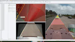
Pavement analysis software leverages the full mobile mapping dataset, including point clouds, pavement images, panoramic camera images, trajectory and GNSS information. Advanced automated pavement inspection extracts information about location and severity of each pothole, rutting, corrugation, depression, bump, shoulder drop-off, different types of cracking, etc., and ties the location of defects to segments within each analyzed road section.
Pavement analysis software combines traditional algorithms with a 3D deep learning model and a 2D deep learning model for high-quality results. The complete dataset and complex combination of analysis methods achieve consistent detection accuracy of 85–90% and will likely improve, while automated calculations eliminate human subjectivity.
It is vital to calculate the International Roughness Index (IRI) and Pavement Condition Index (PCI) for pavement inspection reporting.
Pavement analysis software pushes pavement inspection results through a connected workspace to software used in the field. The system guides workers to areas requiring repair with centimeter-level accuracy, saving time and making more efficient use of taxpayer dollars.
Caltrans currently owns seven mobile mapping systems and plans to add several more for better coverage of all 12 California transportation districts. Compared to visual inspections on highways that can take weeks to complete, mobile mapping data collection combined with software extraction of pavement conditions produces results in just a few days.
Practical Payoffs
The economic case for mobile mapping systems and data analysis enhanced by ML algorithms is supported by reported time savings. While completing over 200 projects each year of varying size, Caltrans is seeing reductions of 10–20% or more in project duration, with some large initiatives like the Interstate-5 corridor work showing substantial returns on a $40 million project investment.
To provide a comparison, the team collected mobile mapping data on a stretch of highway near San Diego at the same time as surveyors performed a manual review of the same area. Collection and analysis of the mobile mapping data was completed in five days, while the manual fieldwork required three and a half weeks and costly nighttime lane closures.
This technology reduces traditional methods from weeks of field work to half-day data collection, with automated processing delivering results within days rather than months.
Enhanced data quality enables better decisions to extend pavement life during the operations and maintenance phases, which industry analysis suggests accounts for 70% of total asset cost. For agencies managing large networks, these operational improvements enable more frequent monitoring and responsive maintenance strategies.
Safety is another key advantage. Typical inspections involve extensive traffic control measures and lane closures, disrupting traffic flow and creating additional safety risks. Mobile mapping systems collect data at normal traffic speeds without requiring traffic management.
This eliminates worker exposure to traffic, addressing the primary cause of roadway worker fatalities. Mobile mapping and ML produce repeatable results and deliver them faster with less risk to workers.
Mobile mapping hardware provides the means to extract information from this data for every transportation asset, for every stage of its lifecycle. This is a central information source that serves all teams in the organization including design, construction and asset management. The high accuracy and granularity of the data results in one data collection and multiple teams reuse one data extraction for added efficiency and cost savings.
State DOT adoption varies significantly, with leaders implementing comprehensive GIS-based mapping portals integrated with information extracted from mobile mapping data. Technology integration trends point toward increasing sophistication that delivers even more time and cost savings as processing capabilities expand.
Sustained Success
The comprehensive pavement management ecosystem allows for efficient data collection, analysis and management. It supports proactive, instead of reactive, asset management for additional cost and time savings. Fixing issues before they become driving hazards protects employees and transportation users while decreasing the cost of asset maintenance.
The transition from traditional visual pavement inspection to a digital workflow with mobile mapping and ML algorithms represents a fundamental transformation in infrastructure management.
Organizations apply advanced analytical tools to accurate data to support better decision-making, improved public satisfaction with proactive maintenance and better compliance with federal performance requirements.
The transportation industry is entering a data-driven era for infrastructure management. ML algorithms enhance mobile mapping technology to provide the foundation for predictive maintenance strategies, condition monitoring and performance-based budget allocation that maximizes the value of infrastructure investment.
Disclaimer: Caltrans remains vendor-neutral and evaluates multiple technologies. The emphasis is on adopting safe, efficient workflows that improve data consistency and reduce field exposure.
Aaron Chamberlin is a senior innovation engineer at Caltrans. He also serves as Caltrans’ construction unmanned aircraft systems coordinator.
Khrystyna Bezborodova is a senior product manager, feature extraction, at Trimble Field Systems.