Pavement management systems needed to keep roads safe
Two civil engineers—Thomas Telford and John Loudon McAdam—are credited with building the first modern roads in the 1800s. Telford would later improve them by analyzing stone thickness, road traffic, realignment, and gradient slopes, according to the Federal Highway Administration.
Pavement management—also known as street studies—was a necessity then, and still is today, as all 50 states have some form of pavement management system (PMS) in place. Despite a community’s pavement network almost always being its largest portion of infrastructure, there is seemingly never enough money for improvements. The American Society of Civil Engineers gave U.S. infrastructure a C- on the group’s 2021 Report Card.
One way to get to a better place is by implementing a proven solution—proper and effective pavement management that incorporates modern technology with pavement strategy to reduce error and save dollars in the long run.
What is Pavement Management?
Pavement management is the process of planning maintenance and repair activities for a network of roads or other paved amenities. This allows communities to optimize pavement conditions and develop a plan to incorporate costs for minor and major road construction. The concept is not anything new; however, in many areas, few communities are participating in long-term planning.
In simple terms, instead of using the roads and letting them deteriorate until it is time to completely rebuild them, road operators and departments of transportation (DOTs) have found a better way. Having a PMS in place prioritizes road maintenance and repairs based on the potential return on investment. A study from 2014 showed rural, two-lane highways with pavement kept in good condition reduced fatalities and injuries by 26% when compared to poorly maintained roads. Like other types of planning, it can reduce headaches, give clarity, improve safety, and ultimately save money.
Benefits go beyond safety and cost. Management systems allow communities to take a long-range view of roadway assets and plan for the future. Setting goals for infrastructure needs is sometimes an incentive for communities to commit to investing in their roads, and street study results can help build a case for funding to help with infrastructure upkeep.
Implementing the study requires knowledge, skill, and monitoring—but can be well worth it. It allows communities to create a strategic plan or program for resurfacing and rehabilitation projects. The bigger picture even allows room to plan for major reconstruction. Communities might feel they do not have the funding for a PMS, but should realize it is a great way to point out roadway and maintenance needs to taxpayers and community leaders.
How it works
While most may not think of a road as a living, breathing thing, the concept is not that far off. Weather changes and time passes. The three items affecting the life of pavement of which we have no control are time, weather, and use. These factors do not fall into a set schedule and are difficult to plan, making monitoring and record-keeping important.
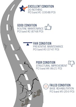
Simply put, pavement management is keeping data on infrastructure. Information is logged into a database where it is analyzed and used to develop tracking metrics, including the average pavement condition index (PCI), a key performance indicator. The lower the PCI for a road segment, the nearer it is to the end of its useful life. Ranking the PCI for your road network shows the backlog of needs. Keeping accurate data allows projects to be ranked in priority order. It also can make pavement deterioration more predictable.
Some cities and towns hire an outside consultant for a professional eye and to incorporate special software. Others keep the job in-house and use a spreadsheet. Factors like material type, age, geometry, drainage, substructure conditions, and construction history should all be recorded. Basic geophysical segmentation, average daily traffic (ADT), functional class, curb reveal, and pavement thickness are also necessary additions.
Communities that have geographic information system (GIS) integration can create a linear route system to help develop a pavement data layer. Engineers can help community leaders understand results and implement a program. When an outside firm manages the system, it reduces worry when municipal employees leave their positions or priorities shift. Once the data is in place, a conversation about repair plans and long-term strategy with priorities and alternatives can begin.
Putting trust in technology
Historically, communities wrestled with the concept of advancing a PMS. Some did not trust the results because the condition ratings were left to human opinion and interpretation. Some struggled since the PMS process can be laborious and costly to complete, requiring significant hours for trained staff to visually inspect the community’s roadway network and time to review road preservation or repair treatments and prepare cost estimates. Repeatability of a PMS to update or show progress was difficult because of the human interpretation component. The data was bulky and challenging to sort through, and it was disconnected from day-to-day operations.
Today, technological improvements in digital imagery, artificial intelligence (AI), and global positioning systems (GPS) remove human bias and significantly reduce the time and cost to collect the data. The result is a digital survey vehicle (DSV). DSVs are equipped with laser crack measurement systems (LCMS)—similar to laser scanning equipment—that is revolutionizing the way the survey industry collects data. LCMS collects detailed images of the pavement surface as the DSV travels over the area. Images are correlated with GPS coordinates and often GIS shapefiles to provide the coordinate location of the pavement condition data collected by the LCMS. As a side benefit, because the quality of pictures and the GPS horizontal coordinate correlation with the photo, often items like sanitary manholes or water valves that show up in the imagery can be located and added to the municipal GIS system from the data collected during this process.
In addition to the digital images collected by the LCMS, pavement data such as the international roughness index, which quantifies rutting deformation of the pavement structure, can be collected simultaneously. The inspection data is uploaded to an industry software program such as PAVER to develop and organize pavement inventory, assess pavement conditions, predict future conditions, and report on past and future pavement performance. Information such as functional class of the roadway segment, ADT, and truck traffic percentage can be added to enhance the data. The result from the software evaluation provides each roadway segment a PCI rating in accordance with ASTM D6433, allowing the various roadway segments to be ranked.
With AI, today’s pavement management software programs use predictive models to project future maintenance treatments for roadway segments based on the data obtained from LCMS. Built-in functionality allows the user to determine the options and associated costs to bring any particular roadway segment to a baseline desired pavement condition. Historically, this required substantial hours by city staff or a consultant to review, assess, and compile cost estimates. Today’s modeling software options allow cost-effective iterations to be more consistent without added human bias.
The resulting database of roadway segments provides an organized pavement inventory, comprehensive data on pavement conditions, predictive models of future pavement conditions, and predictive models for maintenance or reconstruction. The models, which include cost estimates categorized by PCI combined with recommended maintenance treatments and projected future costs, are ready to be used.
Communities with GIS integration can create a linear route system to help develop a pavement data layer to enhance any PMS. Spatial analysis capabilities can be used to match the geographical nature of the road networks. There is a growing trend in integrating GIS data to create a PMS. Advantages include database editing and the ability to visually display results of database queries, stats, and charts on a map of the highway network. Seeing the network conditions in a color-coded chart makes the next steps clearer, especially for nontechnical people.
Now is the time
Many might see addressing the worst roads first as common sense—but that is not always the case. Rather than blowing a budget to reconstruct a mile-long stretch of roadway in terrible condition, the same dollars could preserve or treat a longer stretch of road in less dire condition. Many communities take a reactive approach to road maintenance. This is sometimes because tight budgets force them to wait for complaints before addressing issues, which can cost them more in the long run.
The Minnesota Department of Transportation studied effects of regular maintenance and discovered that when road cracks are repaired early, they can be treated with a rout-and-seal technique for a nominal cost. If the same road deteriorates to a point where a full surface treatment is required, the cost rises by a factor of 16 to maintain. Delaying the need for complete reconstruction saves dollars. This involves regular application of inexpensive preventative maintenance.
Some steps can be taken to improve a community’s chances of having a successful PMS, which could unlock other places for money to be spent. One of the biggest routes to success is gaining support; some of the best infrastructure systems are because of the leadership behind them. Having partners who understand and advocate for infrastructure are key to successful PMS implementation.
Many communities take a reactive approach to road maintenance because that is how they have always done it or because past budget constraints have hampered more proactive methods. By leveraging advances in technology over the last five years, taking steps to address road maintenance needs sooner has become easier, more cost-effective, and integratable. The first step in taking a more proactive approach to managing lane miles in a community is to invest in a thorough PMS and leveraging available software options. This will help improve how and when decisions are made and how limited road funds are spent.
It is increasingly necessary to lengthen the life of infrastructure assets by taking a long-term approach. This not only helps stretch dollars, but also considers resource conservation that affects the environment. When longer life cycles of pavement are involved, the rate of return and cost savings increase. The value of road preservation can be difficult to see in the short term, but a life cycle cost analysis over long periods can provide clarity to a complex equation.
Fehr Graham, a mid-size engineering and environmental firm that operates throughout the Midwest, works with several larger cities and smaller towns to perform multiyear street studies. The team inspects streets and categorizes which to prioritize based on conditions. Working closely with DOTs, the firm determines road rankings based on function, pavement rating, and ADT.
There are benefits to mapping out a plan because it explains needed improvements and funding options to go with it. This helps governing bodies justify where and how to spend, explain it to taxpayers, and have a procedure in an emergency situation.
Return on Investment
Whether cities or towns want a simple or complex system, in the end there is almost always a significant return on investment that, with the right team behind them, can benefit a community and its budget.
Pavement condition survey data is also evolving. Better databases are being implemented every day, but for smaller communities, an expensive software system, drone, or vehicle software is not worth the capital investment as well as the ongoing training costs to keep staff current. In these cases, it likely becomes more cost-effective to look to a trusted, local engineering firm who can evaluate the PCI ranking and help set the associated infrastructure priorities.
Pavement management is all about working together. The people responsible for our roads take on a tremendous burden and have to stay on top of resources, cost increases, and technology. Most of our roads are paved with asphalt or concrete and, despite the simple ingredients, keeping them maintained can be complicated. Pavement management might be the major shift needed to keep roads safe and budgets intact.