Using data to implement signal control solutions
The race to deploy sensors and communications technologies for Smart Cities and Smart Streets is on.
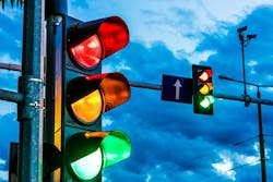
These technologies can be used to better understand and manage traffic, parking, and infrastructure. A significant focus area for investment and deployment is in traffic signal systems, given their substantial contribution to urban congestion and emissions, as well as the staggering annual operation cost of $1.23 billion in the U.S.
With so much invested, traffic signals are still only retimed every few years (occasionally sooner, if citizens complain). This slow improvement cycle is due, in part, to challenges in data collection and monitoring capabilities to support and inform retiming efforts. During the COVID-19 pandemic, some agencies have even pulled back field efforts to retime due to health concerns.
Automated Traffic Signal Performance Measures (ATSPM) is a relatively new suite of performance measures, data collection, and data analysis tools that allow engineers to continuously observe high-resolution traffic signal systems performance—allowing cities to proactively address issues as they occur. ATSPM enables a true performance-based approach to traffic signal operations, maintenance, and management, and can lead to a continuous improvement cycle at intersections that might have otherwise gone untouched for half a decade.
This is a great improvement and a huge leap forward—but it comes at a cost. Installing the necessary sensors, communications, and associated networking equipment to support ATSPM at some locations can cost over $45,000 per intersection. The cost of en masse deployment of ATSPM to the 300,000+ signalized intersections in the U.S. may not be feasible even during the best of economic times. The devastating financial impact of the COVID-19 pandemic has made it even more difficult to continue to deploy and maintain these and similar infrastructure-based signal control solutions despite their proven benefits.
Learning from History
The race to deploy sensor technologies to understand and combat congestion is not new. In the 1980s, agencies deployed speed and volume sensors for both operations and planning purposes. These sensors served a valuable purpose, but were frequently destroyed through milling operations or rendered useless during construction or lane-shifting operations. Agencies also struggled to recalibrate and maintain these sensors—more often defaulting to a “set it and forget it” mentality for decades. It was not uncommon for upwards of 50% of state speed sensors to be nonfunctional at any given point in time.
But 15 years ago, a new disruptive technology emerged—probe vehicle data. Based on GPS devices embedded in vehicles or mobile phones, probe data offered nearly ubiquitous real-time speed measurements and low overall cost, since it no longer required agencies to deploy or maintain roadside equipment. The proliferation of smartphones and embedded devices in vehicles has led to greater sample sizes and consistently high-quality data that are starting to enable new applications—including volume and turning movement estimation. This disruptive technology has all but replaced traditional speed sensor deployments, and many agencies have removed antiquated sensors—viewing them as a maintenance burden, hazard to motorists, and otherwise nonessential to operations.
Agencies have to wonder if ATSPM, despite its benefits, is at risk of being overcome by similar events. State and local governments that already struggle justifying the budget to deploy ATSPM at the level necessary to see measurable benefits are also asking tough questions about whether they are prepared to shoulder the burden of properly maintaining the sensing and communications infrastructure required to keep it functioning properly.
THIS DECADE’S DISRUPTION
History often repeats itself, and probe data from connected vehicles and devices may once again be poised to disrupt the industry. Researchers from Wayne State University, INRIX, and the CATT Laboratory (CATT Lab) have developed methods to leverage high-frequency probe data to mimic many ATSPM capabilities, without the need to deploy any roadside infrastructure or communications equipment.
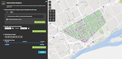
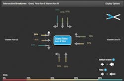
Unlike traditional probe vehicle data aggregated to one-minute intervals, which tends to be sufficient for speed estimation, high-frequency breadcrumb data captures vehicle movements (location, speed, and heading) once every one to three seconds. At this frequency, probe vehicle data can be used to detect slowdowns, stops, and turning movements at intersections. With a few clicks of the mouse, a city traffic signal manager can select any intersection of interest, regardless of the type of equipment installed at the intersection, and analyze its performance.
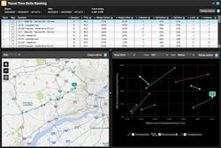
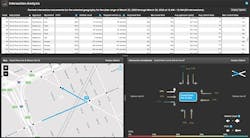
The breadcrumb trail data for the majority of intersections have penetration rates high enough to enable calculations of arrivals on green, travel times, approach speeds, turning movements, intersection delays, and other relevant intersection metrics. The results can be ranked by each metric to identify problem movements at each intersection, such as excessive delays for particular turns, low percentages of arrival on green, etc. In just minutes, the tools aggregate information from trillions of collected waypoints to provide an intuitive view of intersection performance.
This data is available today for most of the relevant traffic signal intersections in the U.S. The analytics are being tested on 3,250 signals in both Austin, Texas and Detroit, Michigan metro areas. Entire new cities can be enabled in less than a week because data is continuously collected from connected vehicles everywhere. A city the size of Detroit, with 1,300 traffic signals, can enable these capabilities for less than 1% of the cost of necessary equipment required for traditional ATSPM. Low cost rapid onboarding is possible because it only requires purchase of data and enabling of that data in the analytics application—there is no need for deployment of any equipment or field staff to any of the requested intersections.
GREAT CITIES NEED GREAT CORRIDORS
Managing the performance of an individual intersection is important, but retiming a single intersection (or cluster along a corridor) can have a dramatic effect on the performance of adjacent corridors. Extrapolating intersection performance to one or more corridors with ATSPM remains a challenge. Because it tracks large groups of vehicles over time, probe data can, again, enable cities to look beyond a single intersection—focusing on the performance of full corridors and adjacent roads. A relatively new set of tools and techniques—originally developed by a team of researchers at Purdue University—have been adapted by the CATT Lab with support from the Pennsylvania DOT to allow cities to quantify corridor-level performance. Cities can evaluate pre- and post-retiming performance, seasonal changes in congestion and reliability, and more.
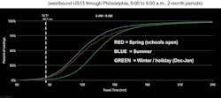
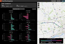
Cumulative Frequency Diagrams (CFDs) visualize both travel time and the reliability of a corridor. These S-shaped curves are especially powerful in exposing changes. As curves get steeper, the travel time becomes more reliable. Flatter curves show less reliable travel times. If the curve shifts to the left, the travel time gets shorter, and as it shifts to the right the travel time gets longer. In the CFD Comparison, the morning traffic along U.S. 13 through Philadelphia tends to be slower in the winter (green line) compared to the spring (red line). The summer months (blue line) have the best travel times and reliability.
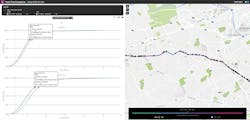
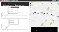
With these tools, signalized corridor performance turns into a simple task of selecting corridors of interest and observing changes in CFD curves and roadway link color changes on the map.
Changes in metrics can be further highlighted by looking at bar charts showing hourly metrics differences between time periods for each selected corridor.
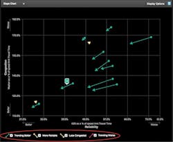
Another tool at the CATT Lab allows cities to rank and compare the changing performance of multiple corridors at the same time—making it easier to prioritize limited budgets and resources. But not all corridors are created equal. Speed limits and the length of corridors can vary greatly. Corridor-level performance analytics at the CATT Lab normalize travel times and reliability metrics to account for these differences. For example, slope charts show how corridor travel time and travel-time reliability changed over time, and how that change compares to other normalized corridors. Visual indicators, such as green and red arrows, show improving and worsening trends, respectively.
Once again, these tools enable cities to quickly identify and prioritize trouble corridors to better leverage limited investment power.
SMART CITIES ON A BUDGET
The cost of infrastructure and sensing technologies can further drive innovation. We deploy infrastructure-based solutions to difficult problems even if the costs are high because we know it works, and we are good at buying hardware. However, the high cost of ownership often spurs additional innovation in areas that can scale a similar solution at a lower cost. Traditional speed sensors were overcome by cheaper and more robust probe vehicle data that could also cover all roads all of the time. ATSPM is the technology leader enabling proactive signal operations for cities, but the cost is also leading to the birth of cheaper alternatives that mimic its capabilities. It is difficult to predict the future, but all cities—especially smart ones—must be wise about how their investments today will impact their budgets and capabilities in the future. After all, it is not how you start the race to deploy Smart Cities technology, it is how you cross the finish line that will matter. It is in this way of thinking, planning, and implementation surrounding a city that truly makes it smart.