Building a Digital Twin for the Next Disaster
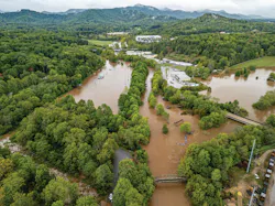
When Hurricane Helene tore through North Carolina in September 2024, it exposed a problem that had been hiding in plain sight.
The state was experienced in preparing for hurricanes and flooding along the coast. But western North Carolina, including Asheville and surrounding communities, was not prepared for the scale of destruction that came with Helene.
Roads closed. Communities were cut off. Infrastructure was damaged. Flooding triggered landslides and created problems that stretched far beyond a single system.
For Elizabeth Losos, executive in residence at Duke University’s Nicholas Institute for Energy, Environment & Sustainability, the storm showed that disaster planning needs to look beyond familiar risks.
“Hurricane Helene was sort of in the mountains of North Carolina,” said Losos, who earned a doctorate in ecology and evolutionary biology from Princeton University. “North Carolina is very used to flooding, and we have a lot of attention in the state government towards both preparedness and recovery, but that’s really all focused on the coast.”
According to Losos, research, funding and planning had historically been concentrated in eastern North Carolina, even as people warned that mountain communities needed more attention.
Helene was a reminder that hazards do not stay neatly within geographic or agency boundaries.
“We’re finding more and more of these across the country,” Losos said, noting that hazards are becoming more intense, more frequent and increasingly connected. A flood, for example, can quickly become a transportation, energy and public safety problem.
Now, Duke is working with Bentley Systems to lay the groundwork to develop a digital twin of North Carolina’s Research Triangle (Raleigh, Durham and Chapel Hill), a detailed virtual model of the region’s infrastructure that could help officials see how roads, bridges, water systems and future development might respond to disasters.
Duke and Bentley Systems also collaborated on the Built to Endure smart guide with Microsoft, AECOM and the American Society of Civil Engineers (ASCE). Realeased in February, this practical guidebook helps small and mid-sized communities design and maintain climate-resilient public infrastructure.
The goal is straightforward: understand what could break before it does.
Enter Digital Twins
The concept may sound complicated, but the basic idea is simple. Rory Linehan, director of infrastructure policy advancement for North America at Bentley Systems, described a digital twin as a digital replica of a physical infrastructure asset that can exchange information with the real-world system.
Take a bridge. Its digital twin could contain information about its condition, structural components and other details. That information can help officials identify problems, plan maintenance and test potential improvements.
“The key is that there’s two ways of communication between both,” Linehan said.
The technology can also be scaled beyond one asset.
“With the advances in technology that we’ve seen, you can use a twin nowadays to see a whole city’s worth of infrastructure,” Linehan said.
That is what makes the Research Triangle project different from a traditional infrastructure database. Instead of looking at one road or bridge at a time, officials can examine how systems interact.
The Triangle is a useful place to test that approach because it has Duke University, the University of North Carolina at Chapel Hill and North Carolina State University. Raleigh also has a digital twin, although it does not include all of the capabilities being considered for the regional model.
Losos hopes the Triangle can become a testing ground for an approach that could eventually be adapted by communities across North Carolina, including places with fewer resources.
“The Triangle is actually relatively speaking pretty well resourced,” she said. “And yet we still don’t have the capacity.”
A Second Storm
Helene was not the only storm that influenced the project. In 2025, Tropical Storm Chantal caused severe flooding in parts of the Triangle. Losos, who lives in Chapel Hill and serves on the town’s planning commission, saw the effects firsthand.
The storm damaged a major commercial area, closed roads and led to rescues. One person died, while residents of a nearby affordable housing community were displaced.
The experience changed how Losos viewed the digital tools being studied through Duke and Bentley’s Built to Endure initiative.
Before Chantal, the project had examined sophisticated resilience efforts in places such as New York City, Singapore and Rotterdam. But Losos realized those examples were not necessarily realistic for smaller communities.
“Those solutions for New York City were not going to help us in Chapel Hill, North Carolina,” she said. “We don’t have the capacity. We don’t have the resources.”
The project shifted toward a more practical question: What technology can smaller and midsize communities actually use?
That question eventually led the team to consider how a regional digital twin could be put to work in its own backyard.
What Communities Need
Building a digital twin is not simply a matter of collecting every piece of infrastructure data available. The team first brought together local officials and infrastructure professionals, including water and sewer representatives, police, stormwater engineers and sustainability staff.
The question was not “What data do you have?” It was “What problems do you need to solve?”
Officials wanted to compare different infrastructure investments, understand the return on those investments and see how new development could affect flooding beyond the development site itself.
They also wanted a better way to communicate risk.
That last point may be one of the most important.
“You can have the best plans, you can have the right policies, but if you haven’t convinced them, it’s just not going to work,” Losos said.
A digital model can show residents and decision-makers what a future scenario might actually look like rather than leaving them to interpret technical reports.
That approach has been used elsewhere. Losos pointed to Wellington, New Zealand, where a digital twin was used to help residents visualize the effects of different flood scenarios and potential decisions.
North Carolina is also developing a Flood Resilience Blueprint, a dashboard and modeling tool intended to help communities understand the risks and costs associated with different flood mitigation options.
Data Must Work Together
There is another major challenge: getting different agencies to speak the same digital language.
Linehan said departments within the same community can use different platforms and definitions for infrastructure data. The same problem can exist between federal, state and local governments.
“The key part to begin with is making sure that you are harmonizing your data where possible,” Linehan said.
Without that foundation, a regional digital twin would have difficulty bringing everything together. Jennifer Goupil, chief resilience officer for the ASCE, said that coordination is critical because disasters affect infrastructure as a system.
“The shock that happens to the community happens to all the infrastructure,” Goupil said.
A road, bridge, water system and power network may be managed by different agencies, but a disaster can affect all of them at once.
That is one of the central ideas behind the Built to Endure smart guide. The guide encourages communities to think about infrastructure as an interconnected system instead of planning each piece separately.
Preparing for the Next Disaster
The project also aims to change how communities think about future risks.
Historical data remains important, but it cannot tell officials everything they need to know about future storms, extreme heat or other hazards.
“We can’t build to yesterday’s climate,” Losos said.
A digital twin could allow officials to test different rainfall levels, heat scenarios, wildfire risks and development patterns before making major decisions.
That could help answer questions such as whether a proposed development will increase flooding downstream, whether a road will remain accessible during a storm or where limited infrastructure dollars could have the greatest impact.
The technology can also help communities consider equity.
Losos pointed to the affordable housing community affected by flooding in Chapel Hill. The area has repeatedly flooded and falling housing prices have contributed to lower-income residents living there because they have fewer options elsewhere.
A digital model can help identify communities that are disproportionately exposed to risk and show how different investments could affect them. But technology cannot make those decisions by itself.
“They’re an assist to what the humans do with them,” Losos said.
People First
Goupil emphasized that digital tools should not replace the people who understand infrastructure firsthand.
Engineers may design a road or bridge, but maintenance and operations crews often know details that never appear in a database.
“They know exactly how that road is maintained,” Goupil said. “What is the problem here with this bridge? ... Those are the folks that know those systems.”
Their knowledge can help make a digital twin more accurate and useful.
Goupil said the goal is to create a process where engineers, planners, maintenance workers, operators and community members can continually provide feedback and improve the model.
Resilience, she said, should not be treated as a straight line from design to construction to maintenance. It is an ongoing process.
Where to Start
One concern with digital twins is that smaller communities may assume the technology is too expensive or complicated.
Linehan pointed to Perry, Iowa, as an example of what is possible on a smaller scale. The town created a digital twin to map sidewalks that needed to meet Americans with Disabilities Act requirements. It also incorporated building information, including roughly 100 years of data on public buildings.
During its next capital improvement planning process, private investment was 75% higher than in the previous five-year plan. Linehan said the community attributed that increase to having access to the additional data.
The lesson is that a digital twin does not have to begin as a massive regional system. It can start with a specific problem and grow from there.
That is also the philosophy behind the Built to Endure smart guide. Goupil said it provides communities with existing frameworks, programs, software and other resources so they do not have to create everything themselves.
“We already built the boat,” Goupil said. “You don’t need to build the boat. You just need to find it and row it.”
For North Carolina, the Research Triangle could be the place where that next step begins. The region has the universities, technology partners and local governments needed to test the idea.
More importantly, it has already seen what happens when infrastructure systems are pushed beyond what communities expected.
The digital twin will not prevent the next hurricane. But it could help communities see the risks sooner, understand how those risks connect and make smarter decisions before the next storm turns a warning into a crisis.
About the Author
 Karina Mazhukhina, Digital Content Specialist
Karina Mazhukhina, Digital Content Specialist
Digital Content Specialist
Karina Mazhukhina has extensive experience in journalism, content marketing, SEO, editorial strategy, and multimedia production. She was previously a real-time national reporter for McClatchy News and a digital journalist for KOMO News, and ABC-TV affiliate in Seattle.