Key south Tucson freeway interchange replacement design improves access and safety for motorists
The Arizona Strategic Safety Plan is a comprehensive framework for reducing fatalities and serious injuries.
Its purpose is to “bring together city, county, federal, and other stakeholders to leverage our collective resources and work together to address transportation safety issues,” said John Halikowski, Arizona Department of Transportation (ADOT) director and plan leader.
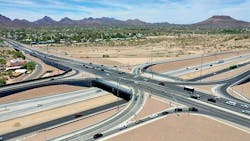
Halikowski explained that when making improvements to highways, ADOT looks for ways to include elements that increase safety for all roadway users, including bicyclists and pedestrians. He pointed to one large, complex project—the new interchange at I-19 and Ajo Way—as an example of the comprehensive and collaborative approach. I-19/Ajo Way had all the elements of a major project, elements that can cause things to go wrong if not handled correctly, from the latest interchange design techniques to community concerns to soils and drainage issues. Thanks to careful planning and stakeholder coordination, the $84 million project was completed in August 2020 and the new intersection is having the desired impact on traffic flow and safety in south Tucson.
International transportation corridor
The I-19 corridor has been under continuous study for improvement and expansion for more than a decade. ADOT outlined seven phases of improvements that are scheduled during the next 25 to 30 years. The intersection of I-19 and Ajo Way (State Route 86) in south Tucson connects a major commercial corridor between Mexico and the U.S. and between Nogales and Tucson, and thus represents the first phase of the program.
Built in 1965, the old interchange is surrounded by a growing neighborhood and sees 100,000 trips a day, with increased traffic projections well into the future. ADOT replaced the partial clover leaf interchange with a single-point urban interchange (SPUI) to improve traffic flow, safety, efficiency, storm water management, and livability for the community.
The project was built in two phases as funding became available, beginning in 2015. Stanley Consultants performed the design and other transportation engineering services on the first phase, the replacement of the original partial cloverleaf traffic interchange at I-19 and Ajo Way. Ames Construction built the first phase while FNF Construction was the contractor for Phase 2.
Design challenges
Designers dealt with a wash crossing that flooded during the summer monsoon season, a narrow bridge crossing of the Santa Cruz River that needed replacing, an old pedestrian bridge that was not ADA compliant, archaeological and cultural considerations, and the need to build the new interchange and associated roadways and bridges while keeping traffic flowing.
Program elements that resulted in the need for creative engineering solutions to these challenges included the interchange bridge configurations, a rerouted box culvert for the wash, a new ADA-compliant pedestrian bridge with approach ramps, a detention basin to provide flood protection for the neighborhood, a braided ramp alignment to provide a new exit to the next interchange at Irvington Road, and aesthetic features that blend with the surroundings.
Phase 1 design
The $40 million first phase of the I-19 and Ajo Way traffic interchange included the following elements, according to ADOT:
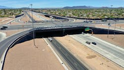
- A new, wider 218-ft-long Ajo Way bridge over I-19 with a single set of traffic signals controlling traffic entering and exiting the interstate rather than signals at multiple locations.
- Widening Ajo Way from two to three lanes in each direction between 16th Avenue east of I-19 and the Santa Cruz River bridge west of I-19.
- Widening the southbound I-19 off-ramp at Irvington Road to provide an additional turn lane and increased capacity to prevent traffic from backing up onto the interstate.
- Reconstructing Lamar Avenue in the neighborhood west of I-19.
- Repaving Elizabeth Drive in the eastern neighborhood and providing a channel to collect storm water and direct it to the detention basin to mitigate flooding.
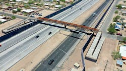
- Constructing I-19 noise walls from Ajo Way to the location of the new pedestrian bridge at Michigan Avenue to protect the neighborhoods from traffic noise and disruptions during construction.
Phase 2 design
In 2018, construction began on the second phase, which included:
- Designing a braided ramp alignment, the first of its kind in southern Arizona, for the southbound I-19 traffic exiting to Irvington Road, which eliminated the merge weave between the southbound Ajo Way entrance ramp and the old Irvington Road exit ramp.
- Reconstructing and widening with new concrete pavement along southbound I-19 within the project area.
- Widening northbound I-19 pavement to add an auxiliary lane between the northbound Irvington Road entrance ramp and the northbound Ajo Way exit ramp.
- Installing I-19 noise walls south of Michigan Avenue and along the south side of Ajo Way between Kostka Avenue and I-19.
- Improving drainage and storm collection.
- Replacing the Michigan Avenue pedestrian bridge, with cyclist and handicap traversable ramps instead of stairs. The new bridge, along with improvements of the Ajo Way crossroad, greatly improved neighborhood mobility and connectivity.
- Replacing the Santa Cruz River Bridge on Ajo Way with two new three-lane bridges with pedestrian walkways, designed by ADOT.
- Constructing bank protection and the new Rodeo Wash outlet into the Santa Cruz River.
- Reconstructing and widening Ajo Way from Holiday Isle to I-19.
A key requirement of the design was that it improve constructability of the numerous projects within the program. Construction had to be phased to allow for continuous flow of automobile and pedestrian traffic. Preliminary designs had not accounted for full-time traffic, so the combined team re-sequenced the work schedule to accommodate traffic and pedestrians during construction.
Engineers changed the planned preliminary drainage culvert routing from one that would disrupt neighborhoods to a design that routed a five-cell box culvert under Ajo Way away from the neighborhood to the north side of the road. Not only did it prevent an 18-month disruption of an adjoining neighborhood, it routed storm drainage along the original historical path, which also improved the impact that the Rodeo Wash had on riverbank erosion when flowing into the Santa Cruz River. The box culvert design also saved approximately $1.1 million compared to the original 900-ft culvert route.
The design team coordinated solutions with the Pima County Regional Flood Control District on drainage issues. Keeping in mind that recent floods had damaged property in adjoining neighborhoods on both sides of the freeway, designers added an overflow detention basin on the southeast corner of the interchange. The basin, which has metered outflow piping connected to the box culvert, has performed well in several major floods since construction.
Interchange bridge
The single point urban interchange (SPUI) was only the third intersection of its kind in southern Arizona. “We had an opportunity at Ajo Way and I-19 to use a design that allows traffic to move more efficiently through the intersection more quickly because drivers only have to move through one set of lights instead of two,” said James Gomes, regional traffic engineer for ADOT’s South Central District.
Widening the existing bridge to accommodate the new SPUI was not possible due to the new roadway profile of Ajo Way being about 4 ft higher than the existing roadway at I-19 as well as the age and the limited vertical clearance of the existing bridge.
Constructability and maintenance of traffic were the two major challenges associated with the construction of the new Ajo Way bridge. The new bridge was constructed in phases to maintain traffic on Ajo Way and I-19 during construction and to allow demolition of the old bridge.
During the first phase, approximately 70 ft (measured at the pier) of the new bridge and approaches was constructed to the south of the old bridge. Nighttime closures of I-19 were required during girder placement, deck form setting, and concrete placement for the deck and exterior parapet. The existing Ajo Way bridge remained in service during phase one. Constructability was enhanced by locating the new abutments within the end spans of the existing bridge to clear existing pier spread footings and abutment battered piles.
During the second phase, Ajo Way traffic was shifted to the completed south portion of the new bridge, and the existing bridge was demolished in a single weekend to minimize disruption of I-19 traffic.
To accommodate the SPUI geometry, the new bridge is approximately 218 ft long and wide enough to fit a clear roadway of 116 ft, as well as a portion of the ramp geometry in each quadrant.
Engineers achieved savings on the superstructure by using a surplus deck concept with a reduced width. In this concept, a few girder lines were eliminated from each side of the bridge and the out-to-out deck width at the pier was reduced from the bridge width at the abutments. To accommodate the deck shape created where the curved SPUI ramps join the bridge, the bridge deck flares at each corner. Abutment diaphragms were placed under the bridge to help carry the load.
The design allowed room for significant pedestrian improvements. The old bridge had a 4.5-ft sidewalk with curb. The new bridge has 20-ft-plus sidewalks on both sides, protected by crash-rated concrete barriers.
Additional challenges
The I-19 and Ajo Way series of projects involved extensive utility relocations, including sanitary sewer, water, telecommunications, and electric. Interchange lights complied with city dark sky anti-reflective codes.
Geotechnical challenges included poor soils for the bridges and noise walls. A 25-ft-deep clay layer had to be accounted for to prevent settling, and bridge foundations used drilled shafts ranging from 52 ft deep at the abutments to 63 ft deep at the pier. The area along the river was also a prehistoric burial ground that contained numerous artifacts, presenting archaeological clearance and scheduling issues.
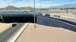
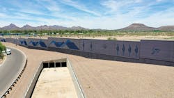
Finally, the project used extensive aesthetic elements to enhance the view scape of the surrounding area and provide a better environment for the freeway neighborhoods. The blue mountains depicted on the noise wall at the intersection mirror the hills behind them. Triangular representations reflect the real mountains and birds, butterflies, and saguaros adorn the walls as well.
ADOT said in its website coverage: “This beautification is but icing on the cake, a visual gift in addition to the benefits of safety and ease of driving that are the core of the two-phase project that revamped the interchange.”
