Designing Roads for a Flood-Prone Future
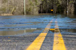
Transportation agencies want durable, long-lasting pavements. Yet current design practices for flexible pavements often underestimate the damage caused by flooding and standing water, leading to roads that fail sooner than expected.
To provide agency professionals with better ways to evaluate diverse flood scenarios, researchers at MIT’s Concrete Sustainability Hub (CSHub) are applying advanced modeling tools to identify and assess flood-related damage. Their research is expected to provide agencies with a quantitative risk-assessment framework for pavements exposed to flooding.
This research should provide actionable guidance for pavement design, maintenance policies and investment decisions in the face of increasing flood risk.
Mechanics of Flood-Related Subgrade Damage
It is important to understand that visual inspection of a pavement following a flood event doesn’t tell the full story. A road may look fine once the water recedes, but real damage can accumulate over weeks or months as the soil beneath the pavement slowly drains.
News headlines after a storm often highlight roads that are submerged, undermined or entirely washed away. Yet catastrophic flooding is not the only way in which water damage poses a threat. One of the most common, and often overlooked, consequences of heavy rainfall or overflow from nearby water bodies is ponding (water standing on the road surface). This standing water can seep into the subgrade through shoulders or surface cracks. As the subgrade becomes saturated, it loses stiffness and strength.
Especially for flexible pavements, a weakened subgrade speeds up cracking, rutting and other forms of pavement distress. When roads are not designed to account for this hidden damage, agencies face more frequent repairs, a shorter-than-expected service life, and, ultimately, higher lifecycle costs for their pavements.
MIT CSHub Advanced Deterioration Modeling
The framework being developed by CSHub researchers will evaluate outcomes in terms of probabilities instead of taking the traditional approach of expressing results as an exact predicted value for a road’s point of failure. Multiple variables are being used in the advanced modeling process to estimate how different flood scenarios affect pavement service life over time. By quantifying uncertainty in this way, risk profiles for performance and serviceability can be created.
At the outset of their study, CSHub researchers evaluated current pavement design standards, including the Mechanistic-Empirical Pavement Design Guide (MEPDG), and found that they do not explicitly incorporate climate inputs related to flooding. MEPDG represents climate using monthly average precipitation, an approach that misses the impact of short duration, high-intensity rainfall events—the events which most often cause ponding.
The researchers identified three critical gaps in existing literature and practice:
- Limited ability to capture where flooding occurs. Existing analyses focus on a single road section and a single ponding condition, ignoring the ways in which flood depth and duration change across different geographical locations. In practice, this means designs may be calibrated to an average condition that does not reflect the worst-affected locations.
- Limited ability to capture repeated flooding over time. Existing studies examine the impact of a single flood event on pavement performance, rather than the combined effects of many events over a pavement's service life. This underrepresents the damage from repeated ponding episodes, especially in regions where moderate floods occur frequently.
- Neglect of cumulative impacts. Long-term evaluations fail to capture how repeated flooding compounds rutting, cracking and overall loss of serviceability. Without explicitly accounting for these cumulative effects in deterioration models, agencies are likely to underestimate the extent to which flooding shortens pavement life and the additional maintenance and rehabilitation required.
Previous CSHub research evaluated the effects of flooding on flexible pavements by modeling ponded water depth and duration with a one-dimensional (1D) numerical simulation of an urban roadway.
The current study extends the 1D simulation to a 2D approach, showing how water flows, in multiple directions, over a given area. The CSHub 2D numerical simulations capture the behavior of urban sections with paved shoulders and non-urban sections with unpaved shoulders.
The result is a model that can better show how water moves across and into different parts of the road structure, giving a more realistic picture of how ponded water infiltrates and moves through a road’s subgrade during a flood.
To translate simulated saturation into expected pavement performance, the study connects soil moisture levels to two standard measures of pavement strength and ride quality: the modulus of resilience and the present serviceability index (PSI).
This makes it possible to estimate how different flood scenarios affect pavement service life over time. The model accounts for pavement design characteristics such as layer configuration, material properties, road type and drainage performance; distress indicators such as cracking and rutting; and flood characteristics, represented through multiple exposure scenarios based on regional flood frequency and storm intensity data.
The study also simulates a range of probable flood events, varying in intensity, duration and frequency, across the pavement’s life cycle. This directly addresses the cumulative effects of repeated flooding, rather than focusing on a single design event.
The model includes a dynamic feedback loop between flooding and pavement deterioration: flooding causes damage, and that damage then makes the pavement more vulnerable to the next flood, creating a cycle of increasing degradation.
Finally, the framework incorporates an economic impact assessment, estimating regional and national maintenance costs for road networks under different flood exposure conditions. By pairing the deterioration model with lifecycle cost tools, the study shows how different design choices and maintenance strategies perform under current and future flood risk.
“Transportation agencies are working with tight budgets and long planning horizons, so the question they face is where to spend the next dollar to generate the best return,” said Danial Amini, a Research Assistant with the CSHub and lead author of a related explainer on flood risk analysis. “The value of risk-based approaches like the one we are developing is that you can better understand the cumulative impacts of flood exposure, and therefore better weigh mitigation measures against everything else competing for funding. It moves the conversation from reacting to the last storm towards planning for future ones.”
Future work could further improve the accuracy of agencies’ risk assessments: machine learning could help them apply their findings across large road networks more quickly, improving planning for maintenance and reconstruction.
Machine learning techniques excel at achieving scale, and scaling risk-assessment results to a regional level would allow integration with lifecycle cost and asset management models, which in turn would help agencies optimize maintenance, rehabilitation and reconstruction schedules.
Flooding poses a significant risk to pavement performance, particularly as climate change causes a greater number of intense rainfall events. Over the past 20 years, the U.S. has experienced a fourfold increase in billion-dollar flood disasters, compared to the period between 1980 and 2000. This trend is expected to continue, making it imperative to rethink how we design and maintain our roads—especially since road networks are critical infrastructure for mobility, logistics, emergency response and the economy as a whole. Keeping our roads functional is not just about convenience; it’s essential for ensuring safety and mobility for everyone.
With approximately 93% of the U.S. paved road network consisting of flexible pavements, understanding how flooding accelerates deterioration is essential. By quantifying “hidden” damage mechanisms, the current CSHub research supports more flood-aware design and maintenance strategies, helping agencies keep their roads performing well even as climate and rainfall patterns continue to change.
Kristin Dispenza is a senior account manager at Advancing Organizational Excellence.