Work Zone Data Exchange to help transportation agencies manage work zones, increase safety
On an average day, two people die in American work zones. Like many statistics about death, some people absorb it and move on. But let that figure sink in. Read an obituary or watch a news story about someone losing their life on a construction site. The statistic is a tragedy.
Shawn Dick was a volunteer firefighter and at 32 years old, he was the father of four young children. On Feb. 1, at 4:57 a.m., he was driving a brightly lit work zone crash truck on I-81 in Virginia, protecting crews as they were putting out cones, when he was rear ended by a tractor trailer. In an instant, he became one of the approximately 750 work zone fatalities that occur on America’s roads each year.
In the surface transportation industry, statistics are ubiquitous and often shrouded in acronyms. The national tool for reporting and analyzing vehicle deaths is called FARS, a benign acronym that belies the seriousness of its mission as America’s Fatality Analysis Reporting System. Somehow, a conversation about numbers and statistics may be more comfortable than a discussion about people and families, but perhaps it is time to be uncomfortable, because every time a number is added to FARS, someone does not come home.
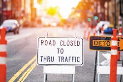
Transportation leaders embrace the goals of Vision Zero to eliminate all traffic fatalities, but no conversation on reducing deaths is complete without addressing the most dangerous place on our roads—the work zone. This is why the U.S. Department of Transportation’s (U.S. DOT) Work Zone Data Exchange (WZDx) initiative is so crucial to roadway safety.
Managing work zones
Work zone safety is a national concern, but work zone management is hyper-local. With 50 independent and sometimes siloed departments of transportation—along with many more regional or city-based authorities—standardization of approach, collaboration, and data-sharing are historically rare. This is to the peril of people who make their living maintaining and repairing our roads.
In many countries, transportation industry standardization and the benefits that come with it are much easier to achieve. Traffic management software developer one.network was founded a decade ago in the U.K. to provide real-time work zone, incident, and event mapping for agencies, the media, and the driving public. While there are dozens of different traffic authorities across the country, all adhere to and benefit from more common and institutionalized standards. If someone wants to travel from London in south central England to the northernmost reaches of Scotland, they can count on a regularly updated and accurate map highlighting work zone locations, duration, and detours to help them along the way. They can also choose to avoid work zones altogether. Obviously, the U.K. is much smaller than the U.S., but the safety implications of standardization are clear. The more drivers are aware of work zones, the less the chance of a crash, and the more drivers who choose to avoid work zones, the safer workers will be. As a value add, fewer vehicles around work zones means less congestion and decreased environmental impact.
Information is crucial, dissemination is key, and time is working against us. In a frightening trend, 521 Americans died in work zone crashes in 2010. In 2019, that number increased to 762. That is 762 fathers, mothers, sons, and daughters who never made it home from work. Reversing that trend is the driving force behind WZDx.
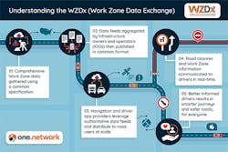
WZDx is an initiative of the U.S. DOT’s Federal Highway Administration (FHWA). It aims to standardize work zone information into a single repository available to agencies, third parties including navigation apps like Google and Waze, as well as to connected and, ultimately, autonomous vehicles. Imagine a series of feeds all contributing to a sole source for quality and timely work zone information, wherever and whenever it is needed.
According to Neil Gaffney from FHWA’s Office of Public Affairs, “The objective is to make travel on public roads safer and more efficient through ubiquitous access to data on work zone activity. Specifically, the project aims to get data on work zones into vehicles to help automated driving systems (ADS) and human drivers navigate more safely,” he said. “A lack of common data standards and convening mechanisms makes it difficult and costly for third parties to access and use these data across various jurisdictions. The Work Zone Data Exchange (WZDx) specification enables infrastructure owners and operators (IOOs) to make harmonized work zone data available for third party use.”
The program is an example of how public and private sector organizations can collaborate effectively for the benefit of society. “Cooperation between the public and private sector has been crucial to the success of WZDx,” Gaffney said. “WZDx working groups are led by volunteer co-chairs who represent a variety of organizations with different backgrounds and focus areas. Their work and the dynamic dialogue between the stakeholders guide the development of the WZDx specification.”
The Work Zone Data Working Group is a multidiscipline collaboration open to leaders and stakeholders from federal, state, local, tribal, academic, and private agencies, organizations, and institutions. Their mandate is to identify and promote best practices for creating, publishing, consuming, mapping, and analyzing work zone activity data. And even though WZDx is new, it is already evolving to accommodate the needs of the future. In December 2021, the Work Zone Data Working Group published version 4.0 of the specification, which incorporated new ideas and advances. Among them is the establishment of two new types of feeds in addition to the existing streams for work zone and detour information. Those new feeds will accommodate smart work zone device data and non-work zone road restrictions. Crucially the group announced the creation of a new object to contain more information about the presence of workers in the work zone. “Having more detailed information about worker presence, as well as improved real-time data from smart work zone devices, is expected to improve driver awareness and increase the safety for workers in work zones,” Gaffney said. “Consequentially, reduction in work zone related crashes and injuries/fatalities would directly support the U.S. DOT’s Vision Zero goals.”
Toward nationwide implementation
In January 2021, the U.S. DOT awarded $2,372,254 in WZDx Demonstration Grants to fund 13 projects in 13 states. While not all grant winners have generated feeds so far, others that have include Iowa Department of Transportation, Maricopa County (Arizona) Department of Transportation, and Massachusetts Department of Transportation. Others who did not receive grants including the Texas Department of Transportation—and most recently, the North Carolina Department of Transportation—created their own WZDx data feeds and are now providing their data to the exchange. But not all feeds are equal. Some only cover small areas or a few work zones, while a few like North Carolina cover the entirety of the state.
While adoption and forward movement are wins, this should not be used to understate the barriers to the program’s eventual success. Developing a feed from scratch is costly and time consuming. In an era of scrutinized transportation budgets and competing priorities, WZDx is facing stiff competition. To counter that, one.network recently committed to developing an FHWA-approved WZDx feed for any agency that wants one, free of charge and with no commitment. With the company’s experience in Europe, one.network already owns a platform that will deliver work zone data in the WZDx protocol.
Last month, the North Carolina Department of Transportation (NCDOT) was the first to take one.network up on its offer, collaborating to develop the most comprehensive FHWA feed to date. NCDOT Traveler Information Engineer Kelly Wells, P.E., led the implementation for the state. “This formalizes many things we have been doing,” she said. “I’m in traffic operations. I saw the synergy between what was going on in this work zone / CAV effort and what I’m doing in traveler information. WZDx is the logical linking of these areas.”
Wells said the need for accurate and timely traffic data delivered to navigation apps was vividly demonstrated not in a work zone, but when Hurricane Matthew roared ashore in North Carolina in 2016. “We had thousands of roads closed in eastern North Carolina and the troopers were coming to us saying, ‘You’ve got to help. I-95 is flooded and when we send people away, they come back an hour later saying, ‘this is where my GPS sent me.’’” By the time Hurricane Florence flooded the Carolinas two years later, Wells had developed manual work-arounds with the major satellite navigation companies to ensure their apps accurately reflected rapidly changing road closures and detours. “When I learned about WZDx, and saw that this was the more efficient and automated way to do what we had been doing manually over the last few years, I was thrilled,” she said.
NCDOT counts road obstructions including crashes, floods, and work zones as “incidents”—and there are a lot of them. Relative to its size, NCDOT maintains more road miles than any other state—80,000 miles in all. On a recent average day, the agency had 268 active incidents of which 250—or 93%—were work zones. For Wells, the math highlights the importance of WZDx. “This is like what the MUTCD (the Manual on Uniform Traffic Control Devices, which created standards and conformity among road signs) was to signing. This is the same for traveler information and CAV navigation. Creating standards we all can use … I think is huge,” she said.
Taking action
Asked what agencies can do to advance WZDx, FHWA spokesperson Gaffney shared a range of actionable possibilities. Among his suggestions:
- Get involved. There is great work being done to advance work zone safety within the stakeholder community.
- Join the FHWA email list to receive monthly newsletters and invitations to Working Group meetings.
- Look for Notice of Funding Opportunities in order to apply for relevant demonstration and deployment grants.
- Share social media posts and graphics, fact sheets, postcards, and more from FHWA’s online communications toolkit.
- Help promote webinars and direct stakeholders to the WZDx website to learn more.
- Review Creating a_WZDx_Feed.md on GitHub, which contains information to assist in creating a WZDx data feed, such as the feed format, business rules, and validation tools.
- Make a new GitHub discussion if you need help implementing the WZDx specification or have questions.
As with every new transportation initiative, this industry tends toward risk aversion. Nobody wants to be first—everyone wants to be second. That is OK because FHWA and the WZDx Working Group have taken the risk out of this initiative. Combined with one.network’s promise to provide free feeds for any agency that asks, there is no reason this industry should not be able to standardize work zone data efficiently and quickly. We cannot prevent every work zone fatal crash with WZDx, but if we can prevent one, or 10, or 50, those are one, or 10, or 50 people who will get to go to their kid’s baseball game, get to the barbecue dinner, or make it to work safely the next day.