Through the gloaming
Reduced visibility conditions such as fog represent a challenging environment for drivers.
Fog reduces visibility and contrast in the visual field, which can negatively affect the perception of depth and speed. When these crucial driving cues are obscured, a driver’s ability to judge appropriate operating speeds may be compromised. Some studies indicate that motorists seem to compensate for these losses by changing following distances to ensure that the taillights of the vehicle in front of them remain visible. Drivers may not reduce speed when driving in fog until they feel their lane-keeping ability is compromised; thus, they may maintain operating speeds too great for close following distances and limited visibilities under fog conditions. These driving behaviors in fog conditions result in a greater likelihood of severe crashes and multiple-vehicle crashes than during clear conditions.
A 12-mile section of I-77 that runs through mountainous terrain in southwestern Virginia experiences severe, recurring fog events. In the past 20 years, several major fog-related multi-vehicle chain-reaction crashes have occurred on this corridor. On Feb. 14, 1997, a chain-reaction crash during fog involved 56 vehicles. Another fog-related series of crashes in September 2005 involved 50 vehicles, causing 25 injuries. On Nov. 16, 2010, visibilities were less than 100 ft when more than 70 vehicles were involved in 10 separate crashes that resulted in two fatalities and 16 injuries, and closed the affected highway for nearly 10 hours. One of the most severe fog crashes on record happened on March 31, 2013, when fog resulting in visibilities of only 167 ft contributed to a series of 17 crashes involving 96 vehicles; three fatalities and 25 injuries were reported, and the crash region took almost 11 hours to clear.
To mitigate similar safety concerns, agencies sometimes install countermeasures such as weather advisory systems and variable speed limits (VSLs) in areas where fog events are common. Weather advisory systems that include dynamic message signs (DMS) to relay weather information, speed advisories, and VSLs have been installed in several states and in other countries. However, not many quantitative evaluations of these systems have been performed. In 2014, the Virginia Department of Transportation (VDOT) awarded a $7.5 million contract to build a VSL system that posts speeds based on available visibility and observed real-time traffic conditions to address the safety concerns on I-77. The system was activated in October 2016, and VDOT sought to determine whether it positively affected safety during fog.
Fully equipped
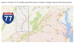
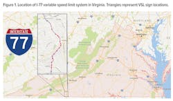
The I-77 VSL system is located from milepost (MP) 0 at the North Carolina border to MP 12, just south of Rte. 702, as shown in Figure 1. Although grades vary across the site, there is a relatively constant +4% grade between the North Carolina state line and MP 6, with southbound traffic traveling downhill. This section of I-77 is a four-lane divided freeway, with an additional truck climbing lane from MP 0 to 7 in the northbound direction. There also are two runaway truck ramps in the southbound direction. The base posted speed limit (PSL) during clear conditions is 65 mph. In 2016, the average annual daily traffic was more than 19,000 vehicles per day in each direction and more than 25% of the traffic was comprised of trucks. Shoulder widths along the corridor range from 4-6 ft for left shoulders and 10-12 ft for right shoulders. In addition to steep grades, there are 11 horizontal curves throughout the site.
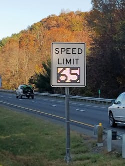
A $7.5 million contract to construct the I-77 VSL was awarded in February 2014. Before construction of the system began, 12 miles of power line and 14 miles of fiber-optic communications infrastructure were installed to support the system installation. The system became operational in October 2016. When construction was completed, the project had added 13 DMS, 36 full-matrix VSL displays, eight speed-limit signs with dynamic VSL cutouts, 25 CCTV cameras, 22 traffic sensors and 14 road weather information system (RWIS) stations with visibility sensors. VSLs are dual mounted in each direction and spaced no more than 1.5 miles apart. During clear conditions, VSLs post the base regulatory speed of 65 mph. Speed limits as low as 30 mph can be posted when conditions dictate. VSL speeds are set based on the visibility data from the RWIS stations and traffic data from traffic detection stations.
Since speed data collected before VSL activation showed that drivers frequently traveled much faster than what is advised by stopping sight distance (SSD)-based safe speed, VDOT was concerned that simply posting the SSD speed based on available visibility could create negative unintended consequences. For example, anomalous readings from visibility sensors or patchy, sparse fog could create cases where SSD-based speeds would be far lower than conditions would dictate. This could create situations where a posted speed was far below the prevailing operating speed, potentially leading to a lack of credibility for the VSLs. Likewise, there was concern that speed variance could increase if a pure SSD-based speed was posted, since some drivers would strictly comply with the posted VSL, while others would travel closer to the pre-VSL observed behavior. Thus, the initial VSL algorithm recommended speeds that were between those of the pre-VSL driving behavior and the SSD safe speed, producing a step function of visibility to determine the posted speed.
At each VSL location, depending on average observed speeds over an interval, the algorithm would determine what the posted VSL should be based on the minimum value of either the mean observed speed or the step-adjusted algorithm. VSLs would not post speeds below 30 mph, and an additional smoothing algorithm would adjust VSLs over the corridor to have a smooth transition between posted VSLs as drivers traveled into and out of fog zones. Speed limits between successive VSL signs could not decrease by more than 15 mph but could return to 65 mph as quickly as possible after the fog zone was exited, provided no additional visibility impacts followed downstream. For example, southbound (SB) VSL signs approaching the fog zone would transition from 60 to 45 to 30 mph at the worst fog locations. As soon as drivers exited the fog zone, the next VSL sign could read 65 mph if visibilities were clear in the remainder of the corridor. VSL speeds at individual locations also were subject to a step range that would not allow them to vary by more than 15 mph over successive five-minute intervals.
In 2014, the Virginia DOT awarded a $7.5 million contract to build a variable speed limit (VSL) system that posts speeds based on available visibility and observed real-time traffic conditions to address the safety concerns on I-77. At each VSL location, depending on average observed speeds over an interval, an algorithm would determine what the posted VSL should be based on the minimum value of either the mean observed speed or the step-adjusted algorithm.
Speed effects
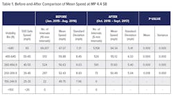
Speeds during fog events were collected for the first year following activation and compared to speeds during the 20 months before activation. Table 1 compares mean speeds and standard deviations by visibility range for the before and after periods at MP 4.4 SB. Visibility is used to group the data since the speed limit remained constant at 65 mph in the before period. The time-aggregation interval for both periods differs, and the number of intervals for both periods are given to establish the number of observations used in the analysis. Table 1 shows that the number of intervals available for visibilities more than 645 ft in the before period is substantially greater than in the after period. In the after period, visibilities more than 645 ft were recorded only if there was fog elsewhere on the corridor.
Hypothesis testing at a confidence level of a = 0.05 showed that mean speeds were reduced across every visibility range in the after period. For every visibility range available, mean speed reductions of 2 to 5 mph were seen. At a 95% confidence interval, there also were reductions of standard deviation across all visibility ranges available. No visibilities less than 250 ft were recorded in the after period at this station, so effects during very dense fog could not be evaluated. This indicates that the system was successful at reducing speeds and variance, which are positive safety surrogate measures.
Crash effects
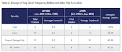
Crashes before and after VSL activation also were compared to determine if the speed reductions produced corresponding safety benefits. Crash analysis for the after period was limited to crash data from October 2016 to August 2018. Since durations of the before-and-after period are different, Table 2 compares crashes using an average number of annual fog crashes. Since the VSL was activated, only eight crashes occurred during a fog event. Of these crashes, two involved injuries but no fatalities. While these results are promising, they only represent 23 months of after data and will need to be revisited using more robust analytical methods as more data accumulates. However, the substantial reductions in severe crashes and overall crashes are certainly a very promising initial indicator of the effectiveness of the system.
Promising future
Overall, the I-77 VSL system is creating positive effects on safety during fog events. Average vehicle speeds and standard deviations were reduced after VSL activation. Although speeds were still above the posted speed limit during fog, they are closer to SSD safe speeds than before VSL activation. The combination of reduced speeds and reduced variances implies increased safety in the corridor. Overall crash frequency and rate during low visibility conditions was less than one-half of pre-VSL activation levels. Although the safety analysis is based on limited data, it is a positive early indication that the system is having a positive impact on safety.
Based on the speed and safety data analyzed in this study, VSLs are a useful tool to affect speeds positively at locations with frequent reduced-visibility events. The system was able to reduce speed during fog, and preliminary data indicate safety improvements. Although the economic and engineering viability of VSLs would need to be analyzed on a site-by-site basis, the results from I-77 indicate that weather VSLs are a positive countermeasure suitable for use at other locations.