NYC Installing Hundreds of Street Sensors. Here’s What They’re Watching
Key Highlights
- NYC DOT is expanding its street sensor network from 20 locations to about 100 citywide to study how people move through streets in real time.
- The sensors track pedestrians, cyclists, buses, and vehicles and capture patterns like speed, turning movements, and mid-block crossings.
- Officials say the data will improve street design and safety planning, with privacy protections ensuring only anonymized information is retained.
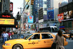
New York City transportation officials are preparing to dramatically expand a pilot program that uses street sensors to track how people travel through the city's streets, bike lanes, sidewalks, and intersections.
The New York City Department of Transportation (NYC DOT) announced it will add sensors at approximately 80 new locations this year, expanding a program that was first tested at 20 intersections in 2023. Once the rollout is complete, the technology will be operating at about 100 locations across all five boroughs.
The goal is to gather more detailed information about how pedestrians, cyclists, bus riders, and drivers use city streets so future transportation projects can be based on real-world behavior rather than limited traffic counts, according to NYC DOT.
The sensors are mounted on existing NYC DOT infrastructure and anonymously collect information about activity on the street. They can count pedestrians, cyclists, buses, and vehicles while also measuring vehicle speeds, tracking turning movements, and showing how different users move through intersections and along corridors.
The technology gives transportation planners a level of detail that has traditionally been difficult to capture. For example, the sensors can identify locations where large numbers of pedestrians regularly cross in the middle of a block instead of using a nearby crosswalk. That information could help determine whether additional crossing opportunities or safety improvements are needed.
The expansion builds on a pilot program that NYC DOT launched in 2023. During that test, the sensors replaced traditional manual traffic counts, which typically require workers to observe traffic activity for a limited period of time.
By operating continuously, the sensors can capture how travel patterns change throughout the day, across different seasons, and under different street conditions. Officials say that provides a more complete picture of how streets function than a short-term count collected during a single observation period.
"Safer street design starts with understanding what is actually happening on the street," NYC DOT Commissioner Mike Flynn said. "These high-tech sensors will help us evaluate how people are walking, biking, and driving so we can design safer streets and encourage safer behavior."
NYC DOT expects the information collected by the sensors to support several transportation planning efforts, including:
- Evaluating whether street redesigns and safety projects are working as intended
- Identifying high-risk locations through "near-miss" data before crashes occur
- Better allocating street space among pedestrians, cyclists, and vehicles
- Improving access to transit stops, loading zones, and local businesses
- Building a long-term dataset that tracks changes in walking and cycling activity across the city
The agency says privacy protections were built into the program from the beginning.
According to NYC DOT, video footage is processed in real time and immediately discarded. Only anonymous data is retained, and faces and license plates are deliberately obscured in any video captured by the system.
The sensors are being provided by Viva and will be installed along a broad mix of corridors, including busy commercial streets and residential neighborhoods. NYC DOT says that variety is important because it will allow the agency to collect information from many different types of streets rather than focusing on a single kind of roadway.
With the network growing from 20 locations to roughly 100, city officials say the technology will help them better understand how New Yorkers actually use streets every day. The agency hopes that information will lead to more informed decisions about future street design, safety improvements, and transportation investments.
Source: NYC DOT
About the Author

Karina Mazhukhina, Digital Content Specialist
Digital Content Specialist
Karina Mazhukhina has extensive experience in journalism, content marketing, SEO, editorial strategy, and multimedia production. She was previously a real-time national reporter for McClatchy News and a digital journalist for KOMO News, and ABC-TV affiliate in Seattle.