As technology continues to evolve, mobile LiDAR scanning equipment will become even more accessible in the years ahead

Rapid developments in mobile light detection and ranging (LiDAR) scanning over the last 15 years have opened the door to many additional applications of the technology in a variety of environments, from city streets and railways to waterways and highways.
Advances in sensor electronics and hardware technology to process data have made mobile LiDAR scanning (MLS) systems more affordable, accurate, flexible, and easily deployable. Improvements in the speed and accuracy of positioning hardware—specifically global navigation satellite system (GNSS) receivers and inertial measurement unit (IMU) sensors—have made MLS an effective and efficient way to quickly capture high-resolution 3-D topographic data over large areas. Such factors have contributed to MLS increasingly being chosen as a go-to method for surveying, especially in the transportation sector.

Overall Benefits of LiDAR
Mobile LiDAR scanning can collect billions of data points at posted travel speeds. Because MLS equipment is mounted on a vehicle, the data-capture process can be accomplished with fewer people and in less time.
Professional surveyors equipped with a mobile LiDAR system can acquire data about the roadway, including signage, ground coverings, power lines, buildings, road markings, pavement surface, and geographic location, all without leaving their vehicle. Not only does this offer benefits to project efficiency, but overall safety as well. For survey crews this means less time in traffic and harm’s way, with fewer distractions and inconveniences to the public from survey equipment, traffic detours, or highway closures. During the COVID-19 pandemic, for instance, mobile scanning has been an ideal solution for social distancing measures, as it requires fewer workers to operate.
While time spent in the field is reduced, additional time is required for data processing. The value of having a rich, point cloud-based data set is that it can be processed to the level required for each project. Numerous software tools can be used to view the raw cloud data, load sections of the point cloud for collaborative work, and extract necessary data for specific project deliverables. Although MLS provides the accuracy required for preliminary work and final design, terrestrial surveying still provides the highest degree of precision. To accommodate this need, terrestrial survey files can be seamlessly merged with those from mobile scanning.
Methods of Collection and System Specifications
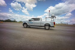
MLS technology is highly adaptable to any type of transportation project, from ports and harbors to bridges and highways. For most transportation projects, the MLS system is mounted on a truck; however, it can also be mounted on a utility terrain vehicle or even a boat.
As an example, the system Foth has deployed, the RIEGL VMX-2HA, offers two high-accuracy LiDAR sensors and can utilize up to nine cameras, each configurable to the task at hand. The cameras can be configured to adapt to the task required. By the numbers, a high laser pulse repetition rate of up to 2 MHz helps produce 2 million measurements and 500 scan lines per second, while collecting data up to 420 meters away with a 360° field of view. The system can be easily configured using a smart geo-fence tool and distance measurement restrictions enabling the right area of coverage to best optimize collection and back office extraction.
This capability helps obtain reliable data for tasks such as pavement analysis and crack indexing, and when paired with the downward and outward facing digital camera sensors, provides detailed imagery of road surfaces. The system has a high-speed 10 Gigabit Ethernet (10 GigE) link which provides faster storage at posted travel speeds of the large amounts of laser and imagery data acquired.

Transportation Applications, Traffic Congestion & Corridor Planning
Creating and maintaining an efficient and modern transportation system requires a focus on safety, infrastructure, and innovation. In addition to planning and surveying transportation corridors, MLS can be used to inspect bridges, tunnels, rail corridors, and utility transmission line corridors. It can also be used to survey airport infrastructure, plan for parking allocations, design urban spaces, and examine areas of traffic congestion.
Suited for projects spanning a wide and long linear space, the MLS system quickly and efficiently collects data and imagery. For example, transportation corridors are typically high-speed areas that can be congested and pose a safety concern for traditional, boots-on-the-ground survey techniques. The MLS system allows data to be collected at posted speeds without disrupting the flow of traffic while eliminating costly lane closures. The equipment is just as useful when scanning multilevel roadways, railroad corridors, tunnels, and in areas with challenging or restricted site access. Mobile scanning is particularly useful in creating a digital map of a highway system, as the data set provides a highly detailed and accurate 3-D digital twin.
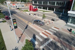
Such capabilities were recently put to work on Court Street, a tight urban corridor in Iowa City, Iowa, which is also an important collector street connecting the east side of Iowa City to the downtown area. Reconstruction of this roadway will replace aging street and sidewalk pavement and upgrade public utilities. As a narrow, high-traffic urban corridor, the use of MLS provided value in improving field personnel safety, reducing traffic delays, and adhering to an aggressive project schedule. With winter weather quickly approaching, being able to collect data pertaining to roadway features, residential driveways, retaining walls, sidewalks, overhead utilities, trees, and traffic signals within a single day was significant. During the quality control and extraction process, the point cloud data was converted into CAD consumable 3-D surfaces, 3-D features, and 3-D linework.

Bridge Inspection & Urban Planning
With more than 600,000 bridges in the country, many of which were built more than 50 years ago, regular inspection is no simple task. Using the MLS system, 3-D models of a bridge can be created for future analysis of any settling, deterioration, and maintenance requirements in a fraction of the time. Mobile scanning can also be used to assess vertical clearance and capture an as-built model shortly after a new bridge is constructed.
Within city settings, MLS is a valuable tool used to conduct as-built surveys and develop models used by urban planners. Whether mapping urban infrastructure, including historical sites, or visualizing and determining how a new development will integrate into an existing space, MLS data provides a variety of added value. Further uses, including designing for telecommunications needs, extensions of highways, identifying floodplains, and developing emergency services and disaster plans, are well-served by MLS. As MLS and cloud-based sharing technologies evolve, consumption of and collaboration on large volumes of data will become increasingly incorporated with project planning.
Another recent example: Grand Prairie Parkway in West Des Moines, Iowa will eventually become a continuous roadway connecting two main thoroughfares and providing the necessary infrastructure to spur redevelopment in the area. The scope of this $84 million project includes a new railroad bridge, realignment of an existing waterway, and establishing a utility corridor. Design is expected to be finished in Fall 2021, with construction running through 2023. When the construction of two new data centers was announced for West Des Moines, the city focused on readying the area. Foth deployed its MLS scanning capabilities to acquire the necessary design data quickly, accurately, and safely.
Taking the MLS system off-road, the team was able to gather additional data required, including the number and caliper of trees to be cleared from the future project site. The additional information assisted in providing more refined estimates within the project’s scope of work. The team also scanned the surrounding environment to develop 3-D models for potential future design needs.
Going even further
The applications for which MLS can be used in the transportation sector are multifold. MLS collects highly detailed information supporting office analysis and creating Pavement Condition Index (PCI) reports on the condition of pavement for operational maintenance. City plans for compliance with the Americans with Disabilities Act (ADA) can also benefit from the technology as city planners work to ensure that pedestrian facilities, such as sidewalks and crossing ramps, meet regulatory standards.
For projects that include a public engagement component, MLS can be used to generate 3-D visualizations and animations that can assist in generating excitement and community support.
Municipalities can also benefit from MLS to catalogue an asset inventory and develop management plans. It can be used to monitor mass transit systems, train routes, roadway conditions, and assess structural soundness and slope stability, to name just a few.
Mobile scanning also serves as a digital data bank. Proactive scanning of public city infrastructure creates a point cloud where different levels of information can be extracted and processed on an as-needed basis without completing additional surveys. Data on the condition of exteriors may be needed one year, while a vegetation inventory might be needed the next.
The future holds much promise to further expand applications for mobile LiDAR scanning. It can play a key role in developing smart cities because of the way the data can collaborate with augmented reality (AR), virtual reality (VR), or mixed reality (MR) to help create a digital twin—a digital replication of the as-built environment. As the Internet of Things develops and sensors are placed on everything from bridges to coffee machines, the built environment will be evermore networked. Advances in machine learning and artificial intelligence will increase the speed of data processing and reduce the need for hands-on work. From utility services to autonomous vehicles, MLS will help create the cities of tomorrow, just as it guides the engineering projects of today.