In 2015, the Florida Department of Transportation (FDOT) consulted with engineering firm RS&H about issues with congestion on I-95 between Atlantic Blvd. and J Turner Butler Blvd. (JTB). RS&H performed a preliminary design and environment study to address the capacity of that five-mile stretch of interstate on the south side of Jacksonville.
“Both the Atlantic and JTB interchanges had been upgraded by FDOT previously, but the segment of I-95 between them was still a choke point,” says Keith Bogart, Jacksonville Highway Group Leader at RS&H. “The first approach was simply to widen the existing roadway—to add some lanes.” However, the project proved to be more complicated than that.
“There were issues with base clearance, pavement overlays, the crest curves on the side roads. None of them met the standard for sight distance. It became a safety issue at that point,” adds Bogart.
The everyday safety issues posed by this stretch of I-95 were further amplified during hurricanes and severe storms, when a safe and accessible evacuation route becomes critical. With this project, RS&H set out to improve roadway safety for the Jacksonville motoring public, bettering the critical hurricane evacuation route while reducing bottleneck traffic.
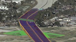
When analyzing the heat diagram of the crashes experienced on that section of road, it was apparent that accidents were clustered around the interchanges. A big part of the cause was determined to be the vertical curves built in the 1960s, which didn’t meet current standards for stopping sight distances. Motorists could not see traffic stalled ahead until it was too late.
For a time, two inside lanes of that expanded stretch of interstate were considered for conversion to toll lanes, but an overall shift in FDOT’s thinking about managed lanes later changed the plan to make them general-use lanes instead.
Partnering with FDOT
As the state was still considering how it wanted to approach the expansion project, RS&H had already gone to work. “We had enough time on this project to learn something new,” says Andrew Poszich, PE, Transportation Engineer with RS&H. That “something new” was Bentley’s OpenRoads Designer (ORD), design modeling software with 3D capabilities that was still in the evolutionary stage. “FDOT was aware that the Bentley technology was in development and wanted to support it. It was a great opportunity to partner with them to figure out how to best use it, and FDOT District 2 thought the I-95 project was a perfect candidate project to leverage this new tech.”
However, some planned features hadn’t yet been incorporated into the software so early in its development process. “Although we all knew there were going to be great benefits to OpenRoads Designer, the complete tool set wasn’t available yet,” says Bogart. That proved to be an opportunity for a win-win-win, however.
Poszich explains that refining the software was a collaborative effort among RS&H, FDOT and Bentley. RS&H’s CAD group visited the FDOT office to do a workshop on the technology, and Bentley partnered with RS&H to develop custom content as they identified specific needs during the design process. Everybody was getting up to speed with the new way of doing things at the same time,” he says.
Seeing it in Three Dimensions
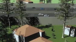
OpenRoads Designer can produce traditional 2D deliverables, support digital transformation and produce advanced 3D modeling to support the needs of a given project. For the I-95 project, RS&H took advantage of the 3D visualization function. This application integrates information from multiple different sources: surveys, point clouds, terrain data, images, geospatial information and more, in order to provide a realistic 3D visualization of the project. That model clearly illustrates the impact of a project on the surrounding area and pinpoints potential conflicts.
Poszich talks about a situation in which ORD saved time and rework. “While modeling a shoulder transition, we found an area that needed adjustment. Without the software, it probably would have taken another week to catch,” he says. In addition, modifications made to the design during any part of the process are incorporated into the workflow and immediately disseminated to all stakeholders and disciplines.
He also appreciates the software’s ability to swiftly generate graphics. “We can do engineering visualizations—renderings for clients so they can see what their projects will look like. And we’re able to do it very quickly and with a lot of detail.”
Previously, RS&H would provide stakeholders with an aerial plan view and a cross section at the property line. Now, the dedicated visualization team would be to produce renderings, animations and flythroughs with extremely fast turnaround times. “We can produce a rendering of a person in his yard, so he can see how a noise wall will impact his property,” he says. “We can also do drive-through videos from the point of view of someone sitting behind the wheel of a car by stitching together 360 degrees of renders.”
For the I-95 pilot project, the technology eliminated the need for creating flat PDF plans for production and internal review, saving RS&H 20 to 30 percent of the time it would have taken to conventionally vet each design alternative under FDOT consideration. When FDOT ultimately decided to remove the express lanes from the I-95 design, RS&H was able to make that change in a fraction of the time it would have taken without the ORD software. It also yielded a high-quality model considerably earlier in the concept stage.
Digital Twins
RS&H also piloted Bentley’s iTwin Design Review tool during the I-95 project. This software produces a digital 3D replica of a physical structure—a “digital twin”—by integrating data into a single federated environment accessible anywhere, by any stakeholder, via the cloud. This approach not only provides a complete visualization of the project; it creates and manages a virtual representation of infrastructure assets throughout their lifecycle.
While the software was still in the development stage during this early access phase, its advantages were already apparent to RS&H. Poszich says, “The platform included a great way to track and incorporate comments during the various review stages. For us, this was iTwin’s shining moment on this project. Being able to dynamically comment in 3D and track those comments throughout the lifecycle of the QC project was a huge efficiency.”
RS&H’s submission of the I-95 JTB to Atlantic project to the Year In Infrastructure 2020 Awards states, “iTwin Design Review provided an ongoing record of 3D design-oriented comments and changes. Comparing digital design alternatives cut 20 to 30 percent of review time, and the time savings helped further analyze the project, providing a higher quality model.”
Poszich adds that while FDOT doesn’t yet mandate digital twin models, that is expected to come in July 2022, at which point, 3D technology will be the legal requirement for quantity takeoff s and constructability reviews. This will generate significant efficiencies of cost and time for project delivery and asset management.
Looking Ahead
Bogart explains that while RS&H still has projects in progress that are using other software, the plan is to transition to OpenRoads Designer for anything new, with all projects to be managed in it eventually. While there was a learning curve with the new technology, he says it was absolutely the right decision.
Poszich agrees, adding, “By leveraging the new workflow, we were able to pull out plan information from the model and see the site in greater detail than we would have with a traditional delivery method. However, I cannot overstate the importance of companies being ready to support their software investment.” Some people picked up the new technology right away, others took longer, but training and quality control were of utmost importance, he adds. “We now have a staff dedicated to ORD. The knowledge the team has gained is invaluable.”
Bogart says, “It’s been an exciting project. I get spoiled working with the Florida DOT—they’re really far ahead in their thinking. I’ve learned a lot—and will learn a lot more before it’s all over.”
The project is now going to the design-build stage and should enter the bidding stage in February 2022. A contractor will be selected by the end of 2022, with construction likely to start in the summer of 2023. That phase is expected to span four or five years until completion. When finished, the expanded section of I-95 will improve quality of life for Jacksonville residents by reducing traffic bottlenecks and providing an enhanced hurricane evacuation route.