Hurricane Beryl Closes Roads in Texas
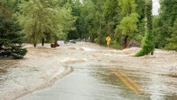
Hurricane Beryl swept ashore in Texas as a Category 1 storm in the early morning hours Monday, lashing Houston with heavy rains and powerful winds, and knocking out power to more than 1 million homes and businesses as fast rising waters caused street flooding and prompted rescues.
Flash flood warnings have been in effect for several areas, including northeastern Brazoria County, southwestern Chambers County, northeastern Fort Bend County, northwestern Galveston County, and Harris County until 8 a.m. Monday.
Beryl had already cut a deadly path through parts of Mexico and the Caribbean before turning toward Texas and hit around 4 a.m. High waters quickly began to close streets in Houston, which was again under flood warnings.
Just before 5 a.m., the National Weather Service estimated between two to four inches of rain had fallen and an additional one to three inches is possible for the affected areas.
So far, the most road closures and high-water locations are in Houston and Texas City. Road closures in Houston are as follows:
- U.S. Highway 69 Southwest Northbound at Dunlavy
- Westpark Tollway Eastbound at Beltway 8
- Beltway 8-South Westbound Before Almeda FM 521
Street flooding is almost impossible to see before the sun comes up. Officials are warning drivers to stay off the roads.
The National Weather Service expected Beryl to weaken to a tropical storm Monday and a tropical depression Tuesday, forecasting a turn to the northeast and increase in speed Monday night and Tuesday.
The storm’s center is expected to move over eastern Texas on Monday and then through the lower Mississippi Valley into the Ohio Valley on Tuesday and Wednesday.
For updated road closures residents can visit the National Weather Service Houston-Galveston.
Source: Houstonchronicle.com, Fox26houston.com