Building Safer, Smarter Streets
By Michael Mastaglio, Contributing Author
The U.S. Department of Transportation’s National Highway Traffic Safety Administration (NHTSA) reported 40,901 road fatalities in 2023 and is estimating 39,345 for 2024.
In 2023, approximately 2.44 million people were injured on America’s roadways. These numbers show the pressing need to enhance transportation systems while meeting the growing demand for safe, inclusive and sustainable transportation options.
Complete Streets concepts and Vision Zero principals are two complementary approaches to roadway safety that promote a culture of prevention. Complete Streets represents a design approach that prioritizes the safety and accessibility of streets for all users, including pedestrians, cyclists, motorists and public transit riders, regardless of age or ability. Vision Zero, by contrast, is a policy framework focused on eliminating traffic-related deaths and serious injuries through data-driven strategies, enforcement, and education.
Together, both approaches aim to prevent tragedies by treating traffic safety as a public health issue and emphasizing proactive, systemic solutions.
By redesigning streets for all users and adopting policies that target the root causes of crashes, these approaches reduce conflicts between modes of travel, lower vehicle speeds, and create safer, more predictable roadway environments.
Complete Streets and Vision Zero strategies are becoming increasingly popular nationwide. Local and state-level policies in Pennsylvania, such as PennDOT Connect, administered by the Pennsylvania Department of Transportation (PennDOT), and PHL Vision Zero, led by Philadelphia, are already having a positive impact. More than 60 communities have adopted a commitment to Vision Zero, including Boston, Chicago, New York and San Francisco.
PennDOT Connect focuses on collaborative planning. At the beginning of every transportation project, the community's needs are prioritized over vehicle traffic, ensuring the best allocation of resources. Through creative solutions and a people-first approach, the program is expanding mobility throughout the commonwealth.
PHL Vision Zero redesigns city streets with safety in mind. Through Complete Streets’ principles, the program prioritizes pedestrians and cyclists with a collaborative effort by several local organizations, led by the city, to enhance traffic safety. The goal is to reach zero traffic fatalities by 2050.
Design countermeasures, such as road diets, roundabouts and median pedestrian refuge islands, are effective strategies for supporting safer intersections and roadways. Thoughtful design can influence behavior, more so than enforcing speed limits.
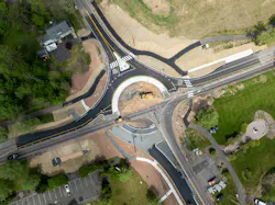
Roundabouts
Roundabouts enhance safety by minimizing severe crashes. They eliminate left-hand turns, reduce conflict points, and slow traffic, decreasing the frequency and severity of crashes, especially right-angle collisions, which are among the most dangerous.
Although widely used in many countries, roundabouts have historically been misunderstood in the United States. This unfamiliarity can make motorists uncomfortable, shifting decision-making back to the driver and disrupting their usual driving routines.
PennDOT, however, has prioritized the use of roundabouts, especially at high-crash intersections. In September 2024, PennDOT released a study examining 47 roundabouts installed on state routes that replaced stop- or signal-controlled intersections. The review focused on intersections with a minimum of three years of pre- and post-installation data and included at least one fatal crash over a 20-year period.
The findings showed a 51% reduction in injury-related crashes and a 7% decrease in total crashes.
Road Diets
Road diets involve narrowing vehicle lanes or reducing the number of lanes on a roadway. This encourages slower driving speeds and can provide space for bike lanes, wider sidewalks and other features that enhance pedestrian and cyclist safety.
According to the Federal Highway Administration (FHWA), road diets contribute to a 19-47% reduction in crashes by reducing vehicle speed, improving mobility and access for all road users. It also supports surrounding land use and activities that result in an enhanced quality of life.
Median Pedestrian Refuge Islands
Statistics shared by FHWA show medians with marked crosswalks reduce pedestrian crashes by 46%. FHWA defines a median as a raised, painted or landscaped strip that separates opposing lanes of traffic.
Medians improve safety by preventing collisions, enhancing traffic flow, and providing space for pedestrian crossings.
A pedestrian refuge island (or crossing area) is a median with a small, raised area to help protect pedestrians crossing a road. It provides a waiting spot between lanes of traffic for pedestrians to cross wide or busy streets safely.
The key benefits of adopting Complete Streets program or Vision Zero policies include:
Enhanced Safety
- Reduce crashes and fatalities by designing safer intersections and roadways.
- Protect vulnerable users, including children, seniors and people with disabilities, through safer, more predictable streets.
Equitable and Inclusive Access
- Ensure all users, including pedestrians, cyclists, drivers and transit riders, can navigate streets safely and comfortably.
Environmental and Health Improvement
- Promote low-emission travel options, reducing greenhouse gas emissions and improving air quality.
- Encourage walking and cycling, supporting healthier lifestyles.
Economic and Community Impact
- Create vibrant, walkable streets that increase foot traffic and support local businesses.
Projects in Action
Philadelphia's Office of Transportation, Infrastructure, and Sustainability (OTIS) is revitalizing Market Street through a Vision Zero Complete Streets Project called Old City Market Street Improvements.
The $16 million initiative aims to update Market Street, for four city blocks from 2nd Street to 6th Street, to reduce the frequency of crashes, increase pedestrian spaces, improve bicycle route connectivity and enhance transit stops along the corridor.
Urban Engineers is leading the project design, which includes implementing a road diet, updating signal equipment, incorporating public art and adding pedestrian and bicycle safety improvements, such as a curbless plaza.
The improvements involve transforming the street into a more bike and pedestrian-friendly space. This includes replacing four lanes with two lanes, adding bike lanes and designating turning lanes as part of a road diet.
Philadelphia’s Washington Avenue is known as a dangerous arterial roadway for pedestrians. To address safety concerns, the Delaware River Waterfront Corporation (DRWC) and the city are partnering on the Washington Avenue Connector Project.
At an estimated cost of $5 million, it will connect South Philadelphia to the Delaware River Waterfront, creating a more vibrant and connected space for people, and will enhance mobility and safety at key intersections.
Bicycle and Pedestrian Safety
With 91% of bicycle and pedestrian crashes happening within New Jersey’s Cumberland County’s three urban centers, improving roadway safety in this area was crucial. Urban Engineer’s comprehensive bicycle and pedestrian safety action plan addressed the high-risk locations by analyzing traffic patterns, accident reports and community input to pinpoint specific locations where safety improvements were most critical.
The plan addressed the current safety concerns and laid the groundwork for long-term improvements. The plan also helped the county secure an FHWA Implementation Grant of $20 million to fund the Chestnut Avenue Safety Improvements and Rehabilitation Project.
The plan also received national recognition through a National Roadway Safety Award from FHWA and an Outstanding Plan Award from the American Planning Association New Jersey Chapter (APA NJ).
Manville’s Main Street
Main Street, located in Manville, N.J., experiences high pedestrian and vehicle traffic due to the many local businesses, schools and bus routes that travel through. The corridor has seen 539 crashes, including pedestrian incidents and a tragic fatality, during the past several years, resulting in an urgent need for improved traffic safety measures.
Critical improvements were designed and implemented throughout the 1.5-mile corridor, spanning 15 intersections from Duke's Parkway to Kennedy Boulevard. These improvements included:
- A road diet.
- ADA-compliant intersections with curb extensions to improve visibility and shorten crossing distances.
- Median pedestrian refuge islands for safer crossings.
- Upgraded traffic signals and Rectangular Rapid Flashing Beacons (RRFBs) at unsignalized intersections.
- Adjustments to the Overheight Vehicle Detection System (OHVDS) under the Conrail bridge to prevent collisions.
Throughout the project, the team faced challenges, including the need to act quickly in response to additional pedestrian fatalities and differences in land records that required more right-of-way acquisitions. Through collaboration with Somerset County, the borough of Manville, New Jersey Transportation Planning Authority (NJTPA), and local stakeholders, this $7 million project was successfully completed.
High Risk Intersections
The Districtwide Safety and Roundabout Program through PennDOT, District 6-0, identified high-risk intersections throughout Southeastern Pennsylvania where a roundabout would be an effective safety measure to reduce traffic crashes.
Candidate intersections were evaluated based on crashes that occurred within 250 feet of the intersection during a five-year period. The program started with a data-driven process to locate potential sites, followed by examining and screening suitable intersection candidates. The goal was to identify the location and advance those intersections to engineering design and through construction implementation.
The team developed a dataset of more than 18,000 intersections on State Routes in the five-county region. ArcGIS’s linear referencing tools were used to create and select the correct route segments per intersection to perform the crash summaries. Intersections with a history of angle and head-on crashes were closely scrutinized.
The project aimed to identify projects for Federal Highway Safety Improvement Program funding, and therefore, crash history data served as the primary screening criterion.
Looking Ahead
As traffic fatalities and injuries remain a critical concern throughout the nation, the need for safer, more inclusive and sustainable transportation infrastructure has never been more urgent. The successful implementation of the above projects is proof that meaningful change is possible when data-driven planning, innovative design and cross-discipline collaboration come together.
By adopting proven strategies, such as roundabouts, road diets, and pedestrian refuge islands, along with visionary frameworks like Complete Streets and Vision Zero, we can reimagine our streets as a means of mobility and as shared public spaces that serve everyone safely and equitably.
Michael Mastaglio, P.E., PTOE, leads Urban Engineers, Inc.’s innovative intersection and interchange design team. He is a nationally recognized multimodal specialist with more than 28 years of experience in transportation planning, design and construction.