Progress in the palm of your hand
An in-house smartphone app was designed specifically for FAST engineers to obtain current data on traffic signals.
American drivers spend an average of 42 hours each year in traffic during peak hours, according to Inrix, a leading transportation analysis company. Idling in traffic not only costs precious time, but also hard-earned money—nearly $300 billion in 2016, an average of $1,400 per driver.
Los Angeles topped the list of the most congested areas in the world, with drivers spending 104 hours in traffic in 2016, whereas drivers in Las Vegas spent significantly less time in traffic, approximately 21 hours during peak commute times. However, that statistic does not mean much to commuters in and around Las Vegas when they are stuck in traffic, whether due to rush hour, road construction or a crash.
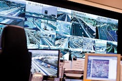
It was 10 years ago that Brian Hoeft was stuck in traffic on U.S. 95 in Las Vegas. While most drivers cannot do much about traffic, Hoeft was an employee at the Freeway and Arterial System of Transportation (FAST), one of the first truly integrated intelligent transportation system (ITS) organizations in the U.S. Operated in partnership by the Regional Transportation Commission of Southern Nevada (RTC), Nevada Department of Transportation and Nevada Highway Patrol, FAST is a traffic management center designed to both monitor and control traffic across all jurisdictions in southern Nevada. Through the use of video imagery, inductive loop detection, radar and visual verification via closed-circuit television cameras along highways and arterials, FAST monitors traffic conditions and manages traffic flows with an integrated system of traffic lights, ramp meters, dynamic message signs and lane-use signals.
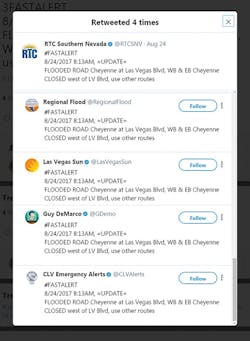
To call attention to the issue of traffic congestion, Hoeft and his staff would send courtesy email updates to RTC executives about major traffic issues and delays handled by the FAST team. Recognizing how useful traffic updates would be to the general public, FAST and the RTC created a process by which updates could be sent via text and email to local commuters to help them plan their trips and avoid traffic delays.
FAST Alerts debuted just as smartphones started to enter the consumer market. (In fact, 2007 was the year Apple released its first iPhone.) Since the service began 10 years ago, more than 15,600 alerts regarding traffic incidents on the freeways and main arterials in southern Nevada have been sent to thousands of subscribers. And as the years have progressed, so too have the technological options available to the RTC to use smartphones to address traffic management issues. For example, social media has become a significant medium to further disseminate FAST Alerts updates. The reach of FAST Alerts today far outpaces the actual subscriber database, given the fact that subscribers, including members of the local media, regularly share the updates via various social media platforms, all easily accessible via smartphone apps.

The Freeway and Arterial System of Transportation (FAST) in southern Nevada is one of the first truly integrated intelligent transportation system (ITS) organizations in the U.S. The Regional Transportation Commission of Southern Nevada (RTC)’s FAST division is co-located with the Nevada Department of Transportation and the Nevada Highway Patrol in a traffic management center designed to both monitor and control traffic across all jurisdictions in southern Nevada.
A sea of orange
In recent years as the Las Vegas valley economy rebounded from the recession, there has been a significant increase in road construction projects, which often result in lane closures, detours and traffic delays—all leading to significant frustration among local commuters. As a regional entity, the RTC saw the opportunity to better coordinate and communicate information about road construction projects underway by the RTC, local jurisdictions, utility companies and private developers. So in 2015, the RTC launched a collaborative campaign called Seeing Orange, a nod to the ubiquitous orange construction cone that has become a symbol of both progress and frustration. By compiling information from all of the local entities conducting road construction projects, Seeing Orange seeks to provide residents with a one-stop shop on road construction projects through a dedicated hotline and website, helping them to better navigate and plan their commutes.
While the RTC continued to send out its FAST Alerts on traffic incidents and respond to hundreds of inquiries via Seeing Orange, it also realized more people were turning to crowd-sourced smartphone apps to stay updated on traffic conditions in general. So in early 2016, the RTC saw an opportunity to broaden its Seeing Orange campaign through a partnership with Waze, a free, real-time, crowdsourced navigation app with a reported 80 million active monthly users worldwide.
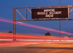
Dynamic message signs across southern Nevada share critical traffic, construction and crash information with motorists.
Making way with Waze
Waze’s Connected Citizens Program brings cities and citizens together to answer the question, “What’s happening, and where?” Established as a two-way data share, the RTC provides real-time, government-reported data on road construction, traffic accidents and road closures to Waze, while Waze provides the RTC with incident and traffic-slowdown information directly from the source: drivers.
Specifically, the RTC provides three feeds of traffic information to Waze. First, traffic-accident information from a feed generated by FAST is updated in Waze approximately every two minutes. Second, Waze uploads information from an RTC database populated by local jurisdictions, utility companies and developers that outlines road construction projects that will result in lane closures. And third, the RTC provides Waze with a listing of all major events, such as parades or road construction projects, that will result in complete road closures.
In turn, Waze provides a comprehensive feed to the RTC of all of the real-time user-generated posts in southern Nevada, such as locations of heavy traffic, stopped traffic, broken traffic lights, police activity, traffic accidents and road hazards. This data supplements what FAST has from its own monitoring efforts, allowing the agency to have a more comprehensive view of traffic conditions from a driver’s perspective and enabling it to address traffic management issues in real time.
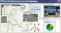
The FAST Dashboard is an easy-to-understand web-based user interface that provides roadway performance and real-time traffic information in a wide variety of user-selectable and user-customizable displays.
In-house expertise
The RTC’s commitment to leveraging smartphone technology does not end, however, with the commuter. FAST engineer Gang Xie created a smartphone app specifically for FAST engineers to obtain current data on traffic signals. The app uses automated-vehicle locator technology to track a vehicle’s location, time and speed in one-second intervals. The data are then uploaded to the cloud and provide FAST engineers with information on how long a trip takes, when and where vehicles trigger green or red lights, how long the vehicle waits at each traffic light, and how far they are from the intersection while waiting. The app is used in-house at FAST by nearly 50 technicians daily as they drive around the valley for work and pleasure.
The data it provides helps the agency respond to the traffic in southern Nevada by adjusting traffic signals to enable vehicles to move more efficiently and prevent delays, especially at peak travel times. To date, data from the in-house app, coupled with information gathered from a third-party traffic signal app and from RTC transit vehicles, has provided the RTC and FAST with information on almost 60,000 trips and more than 300,000 intersections.
The in-house app is the second technology that Xie created to improve data collection and incident response for traffic management operations in southern Nevada. In 2010, Xie developed the FAST Dashboard, an easy-to-understand web-based user interface that provides roadway performance and real-time traffic information in a wide variety of user-selectable and user-customizable displays. It utilizes various free platforms, technologies and tools such as Microsoft .NET platform, Silverlight, Bing Map and VLC media player to capture snapshots or stream live videos from the traffic cameras.
The FAST Dashboard collects and displays the raw data automatically gathered by ITS technology in southern Nevada and incident-specific data logged by FAST’s technicians. By integrating these data, the FAST Dashboard not only develops maps, charts and graphs showing traffic trends and “report cards” on freeway performance, it also enables FAST technicians to improve efficiency and responsiveness in calibrating traffic flow detectors and signals.
Viewable on smartphones, the dashboard can provide the public with basic travel-time-related information and camera snapshots of current conditions. For FAST technical analysts, it is a multi-featured analytical tool used to determine the magnitude of traffic delays for a particular road or area, facilitating improved incident response and traffic management.
The FAST Dashboard immediately yielded great time and cost savings in the processing of raw data. It has been extensively utilized to convey live traffic information to the public or fleet dispatchers, download traffic counts, generate graphs and plots for university research/teaching purposes, present improvements for decision-making, and monitor ITS device health. As a result, it was honored in 2014 by the U.S. DOT with a Data Innovation Challenge Award.
The reach of FAST Alerts today far outpaces the actual subscriber database given the fact that subscribers, including members of the local media, regularly share the updates via various social media platforms, all easily accessible via smartphone apps.
Emerging technologies
The RTC and FAST, along with stakeholders such as the Nevada Center for Advanced Mobility, also pursue partnerships with third-party smartphone app vendors to further improve traffic management in the growing Las Vegas valley. The most recent partnership is with Nexar, an artificial intelligence-based dashcam app that leverages a phone’s sensors to analyze and understand the vehicle’s surroundings. As a result, the app can measure vehicle speed, braking and turns as well as record video outside of a vehicle, a tool that is especially helpful in accident reconstruction.
Nexar forms a unique vehicle-to-vehicle network. By connecting all the app’s dashcam instances into a real-time alert network, Nexar detects dangers on the road and shares that information with nearby vehicles to predict and prevent collisions, including forward-collision warnings, without the need for hardware other than a smartphone.
Reporting a 24% reduction in car collisions within its network, Nexar is well established in New York City and San Francisco. Nevada is the first statewide launch of the app’s vehicle-to-vehicle network. Since launching in Nevada six months ago, Nexar has deployed in more than 200 vehicles in Las Vegas, and Nexar drivers have accumulated more than 50,000 driving hours. This accounts for nearly half a million miles of road driven in Nevada alone.
In addition to driver-warning capabilities, the Nexar network will improve RTC FAST’s already state-of-the-art traffic management center by providing aggregated live sensor and vision data that offer a series of benefits for communities and drivers, such as live infrastructure mapping that can enhance efforts to relieve congestion and improve rapid emergency response assistance—with the ultimate result being collision reduction.
As technology continues to evolve, smartphones can do more than ever before. Now, smartphones are powerful tools the RTC and traffic management agencies like FAST are leveraging to provide traffic updates to drivers, obtain data on traffic flows and trends to improve traffic management and infrastructure planning, and analyze road conditions to ultimately create a safer and more efficient commute. The RTC continues to review, develop and implement technology advances that enable it to make traffic management more efficient and responsive.
---------
About the author: Quigley is general manager of the Regional Transportation Commission of Southern Nevada.