Map points to it

How do major American cities like Dallas, Texas, address congestion and the splintering of neighborhoods caused by the tangled knot of aging urban interstates?
How do they rehabilitate them into models that foster urban renewal and transportation efficiency? That is the challenge that the Texas Department of Transportation (TxDOT), along with stakeholders from that city’s private and public sector, undertook in 2015 with its ambitious and comprehensive Dallas City Center Master Assessment Process (CityMAP).
Long considered a “way to get there” or “get through there,” urban interstates have created barriers to neighborhoods and have segregated communities from each other. Downtown Dallas’ major arteries, primarily I-30 and I-45, U.S. Highway 75 and I-35E, were found to be so clogged that Texas government and transportation officials feared their surrounding urban neighborhoods were suffering what would be analogous to a heart attack, having its economic “oxygen” choked off.
In 2014, even before the CityMAP process began, TxDOT officials were so concerned with the growing urban congestion of its big cities that Gov. Greg Abbott initiated his Texas Clear Lanes Program. The goals were to identify and address the state’s most congested chokepoints, and work with planners and engineers to design and build new roads in order to stimulate economic development and create jobs. With several of its major highways intersecting and creating chokepoints, Dallas was a prime candidate for the governor’s new program. Also, Dallas has the dubious distinction of having six freeways that fall into the top 25 of the 100 most congested roadways in Texas, greatly impeding the North Texas freeway system as well as local and state economies. Studies by the North Central Texas Council of Governments showed that “if no improvements are made, by 2040 the average trip would take 98% longer to complete in congested conditions” and “portions of those highways would need to be replaced to address maintenance and safety issues.” Officials realized that there was no simple “fix” to such problems, particularly given the challenges of working within the crucible of a major urban area.
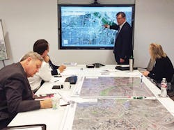
The team at TxDOT studied traffic patterns into and around downtown Dallas.
Just reimagine
In response to these findings, Dallas CityMAP was initiated with the ambitious and innovative goal to reimagine its downtown connectivity and rejoin neighborhoods split apart by its tangle of freeways.
Led by TxDOT and comprised of representatives from a host of public and private entities, including A Coalition for a New Dallas, West Dallas Chamber, Downtown Dallas Inc. (DDI), Saint Luke Community United Methodist Church, city of Dallas, Dallas County, North Central Texas Council of Governments (NCTCOG) and Dallas Area Rapid Transit (DART), stakeholders started discussions about the future of Dallas’ urban core. To begin the dialogue, TxDOT relied on the 1997 Major Transportation Investment Study (MTIS) for the Trinity Parkway and downtown Dallas highways. Though much smaller, the MTIS outlined a recommended plan of action, much of which has been implemented in the CityMAP project.
According to Tony Hartsel, TxDOT Public Information Officer, CityMAP provided the public input to help guide the future design direction for highways within a geographic area that encompassed nearly 30 miles of freeway as well as communities near those highways. The information was filtered through the context of three important elements: mobility, livability and economic vitality.
“The team listened and collected input from hundreds of community leaders, stakeholders and elected officials, primarily through one-on-one interviews as well as a number of public meetings,” Hartsel said. “The team also collected data, analyzed current corridor design projects and studied traffic patterns into and around the downtown area collected via Bluetooth technology.”
Hartsel said the process generated strong public support and buy-in that resulted in a robust final document delivered at the end of 2016. He said among the topics addressed were quality-of-life and neighborhood character; community and urban street connections; regional mobility and safety; economic development and future growth; and policy, partnership and funding considerations.
“CityMAP lays the groundwork for short- and long-term multi-partner decision-making on project prioritization, funding and construction,” Hartsel said. “While it may not be used everywhere, it offers solid guidance and best practices for major project planning in the future.”
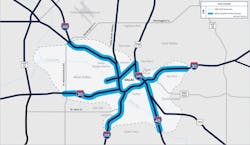
A map of the highways in the study area for the Dallas CityMAP program.
Hartsel said CityMAP captures the “art of the possible” as envisioned by the local community and allows municipalities to provide long-term planning options in a holistic, strategic manner that saves time and resources. It is a one-stop process that is a catalyst for ideas that come from everyday citizens to the C-suite.
“Framing all the options through a comprehensive public input process will minimize public or local partner resistance as well as avoid costly planning and design delays,” Hartsel said. “The document provides TxDOT with the mechanism to test options early for public acceptance, operational performance, funding feasibility and partnership potential as we move forward.”
Currently, CityMAP presents a range of visionary and transformative alternatives for the future of the city as well as providing options for major downtown-area highways, roadway expansions, complete streets enhancements and even deck parks, to name a few. The report also attempts to quantify the potential economic development impacts from different scenarios.
“In addition, CityMAP is designed to be visited regularly as population increases, and growth and development pressures evolve,” Hartsel said. “Just as regional transportation plans are updated every three to five years, it is TxDOT’s desire to revisit and update this document regularly, and allow it to influence future project planning.” With Dallas CityMAP now complete, the plan is to accept additional input from its partners at the city, county and downtown interests as well as other interested parties for the path forward on agreed-upon priority projects.
James Frye, lead consultant for HNTB, the Dallas-based architecture, civil engineering and construction management firm that serves as the prime consultant to the project, said the team was able to harness the creativity of residents and community leaders, and use their ideas to formulate various scenarios to address traffic problems while reconnecting neighborhoods.
“There was a sense of neutrality in the consulting team,” Frye said. “When we met with people, it was a very open and inviting dialogue. We said, literally, ‘Tell us your thoughts regarding the Dallas downtown freeway network.’”

The CityMAP consulting team was able to bring in ideas from residents and community leaders to address traffic issues in the city of Dallas.
Everything was on the table, including discussion on how to fix schools and how to bring back the middle class, adding that the reasoning was “if development and planning were done right, it could foster additional development that would substantially increase land values, boosting property tax funds for the city, county and school districts.”
Frye said people had high expectations from the start: “‘Bring back the middle class’ is not what you typically hear in a TxDOT meeting.”
Brandi Crawford, HNTB’s deputy project manager, said it was clear from the beginning that a multidisciplinary team of experts was necessary to address the breadth and depth of issues elicited by CityMAP.
“It emerged as a holistic endeavor that included an economist, urban designers, transportation planners, outreach specialists and landscape architects,” she said. “It was inevitable that we addressed quality-of-life issues.”
She recounted that Dallas’s esteemed county judge, Clay Jenkins, cast the project as nothing short of a renaissance for the city’s downtown.
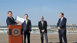
Mayor Mike Rawlings (at podium) stands with other Dallas officials to present the CityMAP assessment report at a press conference.
Below grade
Frye said CityMAP yielded many options, none of which were too grandiose to consider, such as the removal of I-345. He said removing it would create space for retail, residential and commercial developments as well as small parks while stimulating an estimated $500 million in development, raising neighborhood property values by about $2.5 million, and increasing property tax revenue by $80 million.
“The final recommendation,” Frye said, “creates an option for modifying or moving it below ground as southern Dallas communities preferred keeping the I-345 facility in some capacity as it provides access to jobs to the north. They feared a system of boulevards without increased public transit could slow their commutes, increasing transportation costs that are already a large portion of their overall income.”
Frye points to TxDOT’s I-35E Southern Gateway, a design-build project upon which CityMAP has had an immediate impact. He said plans call for improved thoroughfares over and under the new freeway to connect its historic neighborhoods to the commercial district of Oak Cliff. Options in this scenario for the 2-mile stretch of land, which takes in the Dallas Zoo, include sunken lanes, similar to Dallas’ North Central Expressway, and potential deck parks modeled after Dallas’ Klyde Warren Park, along with complete street bridges.
“The team met quickly to inform that project’s designers of new ideas suggested by stakeholders, one of which was the reopening of 10th Street, which had been closed to serve as a pedestrian tunnel under the freeway,” he said.
Planners projected those and other improvements would bring about $167 million in new land value and nearly 1,000 new jobs. The estimated cost for that scenario: $662 million.
Another project given strong consideration under CityMAP is I-345, whose long-range plans extend out 25 years. Under consideration is whether to remove, modify or lower the structure. Opened in 1968, it provided direct access from Rte. 75, I-30 and I-45 to downtown Elm, Main and Commerce streets via collector-distribution roads and ramps. The freeway absorbed the traffic demands on Rte. 75 and I-45 but created a visible separation between downtown and the neighborhood district of Deep Ellum.
Crawford said that the CityMAP project most likely to be green-lighted will be recommendations for I-30, which will enhance connectivity north and south along the highway.
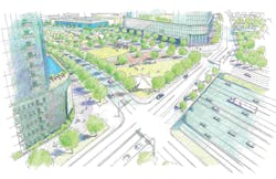
A mock-up of some of the plans for the downtown Dallas area being considered under CityMAP.
“Improving the connection between downtown Dallas and the Farmers Market, which includes the historically significant Cedars neighborhood, will help realize the economic potential of this area,” she said. “The freeway will have a major impact on traffic mobility, safety and other corridor interchanges but, more importantly, the I-30 concept reflects an investment in downtown with the construction of several public plazas, parks and a deck park near the Convention Center.”
In addition, she said the western end of I-30 will be the site for the city’s station of the proposed Houston-Dallas high-speed rail.
“What impressed me the most,” she added, “was the consideration given to the Cedars neighborhood in the development plan. It is an area where 20-40% of the residents are below the poverty line, so housing affordability and the negative impacts of gentrification have been seriously considered and are anticipated.”
Frye said the opportunities along I-30 downtown and immediately east support Dallas Mayor Mike Rawlings’ Grow South initiative.
“TxDOT’s I-30 project can serve as the catalyst [to] make this vision become a reality quicker,” he said.
Frye also said that the scope of the CityMAP project rendered it impossible to find a precedent.
“We could not find anything like it when we started,” he said. “CityMAP’s 400-page document looks at the whole system in an urban environment with all its corridors, streets and neighborhoods.
Crawford agreed. “We couldn’t identify an end product because we had to speak with everyone before knowing what that would be. CityMAP may have just changed how to begin every transportation project.”