Bubble maker
Just when you think you’ve seen everything, along comes a game-changing storm like Hurricane Harvey.
No one in Texas had ever seen that much rain. On Aug. 30, 2017, a rain gauge near Cedar Bayou, Texas, measured 51.88 in. of rainfall. That broke a record for the continental U.S. set in 1978. Cedar Bayou is about 30 miles east of Houston.
Besides all the property damage and human misery that Harvey left behind, the storm also left road issues that no one had ever seen before. Texas Department of Transportation (TxDOT) personnel in the Houston District were presented with a couple of perplexing problems. There was unprecedented disruption and damage to Texas roadways. About a mile of SH 6 in Harris County from Clay Road to I-10 was covered with up to 7 ft of water for two weeks. Multiple farm-to-market roads in Brazoria County also were submerged for days by 1-7 ft of water.
As a result, many of these roadways exhibited characteristics that TxDOT Houston District personnel had never seen before. In five locations, the pavement bulged 12 in. above the normal road surface. In other locations, continuous streams of air bubbles escaped from cracks or joints in the road. TxDOT was concerned the bubbles might have been from damaged pipelines. When the bubbles were deemed harmless, the question became, “Where are these coming from?” What was the explanation? Were areas beneath the pavement washed out? Was the pavement structure stable? Had asphalt delaminated from the concrete base? Could the roads possibly collapse? The roads could not be opened without answers.
TxDOT turned to the Texas A&M Transportation Institute’s (TTI) forensic pavement expert, Senior Research Engineer Tom Scullion, and his team, Research Specialist Lee Gustavus and Research Associate Jason Huddleston.
Cores showed that after a month under water, the asphalt on SH 6 was still bonded to the concrete, which was attributed to an excellent asphalt rubber seal coat bonding the asphalt and concrete layers together.
The tech
The agency asked Scullion and his team to survey the affected roadways and assess the damage. Using ground-penetrating radar (GPR), TTI’s Total Pavements Acceptance Device (TPAD) automated rolling deflectometer and core sampling, TTI evaluated the health of all the affected roadways.
The TPAD is a highly modified geological surveying “thumper” truck designed for seismic testing. Scullion estimates that it cost approximately $1 million to create the TPAD. Even though the initial cost was high, he figured that TxDOT saves that much money on nearly every project that the TPAD is involved in. The TPAD was developed through a joint effort of TTI, TxDOT, the Center for Transportation Research at the University of Texas and Industrial Vehicles International in Tulsa, Okla.
The TPAD combines rolling dynamic deflectometers (RDD) with GPR. The RDD deflections are measured by three rolling geophones under a vibratory load applied at a frequency of 30 Hz. Traveling at 2 mph, deflection data measurements are collected approximately every 2 in. of travel.
The two technologies are coupled with video cameras and global positioning equipment. Combining these non-destructive testing methods into a single machine produces maintenance and rehabilitation data that is more comprehensive and useful than either device is separately.
Researchers also used ground-coupled radar. The unit is a 2-ft-by-2-ft wheel-mounted device that is pushed by an operator. The frequencies used can penetrate most soils to a depth of 6-8 ft. The device is ideal for locating pipes and other infrastructure. It also can detect air- or water-filled voids.
Priority one
Determining the health of SH 6 was the first priority. A major artery in Harris County, it carries tens of thousands of vehicles each day; reopening it was critical.
“We recorded deflections every 2 in. down the road. From the data we collected, we saw no indication of delaminations or washout, voided areas. There were no anomalies in that data. After two weeks under water, the asphalt was still bonded to the concrete, which was attributed to an excellent asphalt rubber seal coat bonding the asphalt and concrete layers together,” Scullion said.
“TTI has some unique, specialized equipment,” Scullion explained. “If you’re on a concrete slab with good soil support below, the vibrations that the TPAD sends out provide a uniform picture of the base. When you locate a spot where there is nothing below the slab, it’s almost like a trampoline. Everything starts bouncing up and down. Those lack-of-support signatures are very clear. That’s what we were looking for. We didn’t see any.”
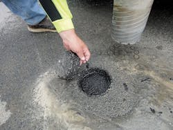
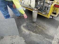
Radar data indicated three areas that warranted coring. The cores showed that, after a month under water, the asphalt was still bonded to the concrete, which was attributed to an excellent asphalt rubber seal coat bonding the asphalt and concrete layers together. Following the assessment, SH 6 was reopened to traffic.
Mark Wooldridge, director of maintenance for the TxDOT Houston District, said, “TTI’s equipment and support were exceptional. The quick, timely response allowed us to verify that damage was not present on the roadways in question and enabled reopening of the roadways to traffic. The special equipment provided a much more thorough and accurate evaluation of the pavement structure than point testing, and the immediate interpretation and availability of data facilitated quick decision-making.”
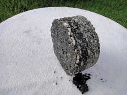
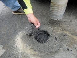
TTI researchers took core samples near each dome along the Brazoria County roadways impacted by Harvey flooding. The samples showed a clear break in the middle of the core as well as an interface that was completely delaminated.
Next problem area
Scullion and his team moved on to Brazoria County near Angleton. These roads exhibited strange air bubbles and domes—humped sections of pavement expanding upward as air is forced from beneath the pavement.
“I’ve been in this business for a very long time. I had never seen anything like these domes,” said Scullion. “Neither had TxDOT personnel.”
Little is known about the original construction of these old farm-to-market roads. There was not a good set of plans for them. The original construction plans are available, but maintenance plans are not as complete, if available at all. TxDOT wanted to be sure there were no voids under the surface that might collapse.
As flood waters receded, the domes sank back to normal pavement level. Fortunately, TxDOT personnel had marked the locations of the domes. The TPAD and GPR found no major anomalies beneath the road surface. Measurements were taken a quarter-mile before each mark and a quarter-mile after. Researchers were looking for high deflections or void signatures in the GPR data. Radar data showed that there was 8-10 in. of asphalt on a concrete base. The radar data did not show any signs of delamination. It did show a deteriorated layer of asphalt.
“From the data we collected, we could not see any voids. We had no explanation for what had occurred,” Scullion said.
The researchers then took core samples near each dome. When the cores were examined, the problem was obvious. Every core had 8-10 in. of asphalt and a concrete slab. There were no cracks in the concrete slab. While coring, researchers also drove a dynamic cone penetrometer into the exposed base 3 ft beneath the asphalt surface. The base below the concrete was solid. In every one of the cores, there was a clear break in the middle of the core. There was an interface that was completely delaminated, plus the deteriorated layer.
After analyzing the data, Scullion and his team concluded the domes and bubbles were caused by the weight of the flood waters pressing down on the air trapped inside the low-density asphalt layer. Like water being squeezed from a sponge, air was being forced from the voids in the low-density asphalt layer.
“That air had to get out somewhere. If it found a joint or crack, that’s where the bubbles came from. If there was not a crack or joint nearby, the asphalt-concrete bond broke, causing the pavement to rise,” Scullion noted.
Because of the delamination, there was a question about the effect on the surface layer. Scullion said that anytime layers peel apart, there is a potential for the top layer to crack: “The road might have lasted for another 15 years without the flooding. We estimate that the life has been reduced by half, but it’s not an emergency.” No immediate action was required. Scullion told TxDOT to watch for accelerated cracking in those areas.
Michelle Milliard, area engineer in TxDOT’s Brazoria County office, was appreciative of TTI’s efforts. “The bubbles coming out of these pavements really had us concerned about fractured pipes or voids forming. The testing performed by TTI provided us with a logical explanation of this highly unusual phenomena. Thankfully no major defects were found and we continue to monitor the sections and have seen nothing unusual,” she said.
After all testing was completed, there were no major safety concerns, and the roads were opened to traffic. Scullion said the condition of the roads after the flooding was a tribute to the Houston District’s pavement designs and use of superior materials over the past 60 years.


