Land scoping
Mowing is a vital roadside maintenance activity for public agencies, yet it can be perceived as a routine, ordinary task.
Nonetheless, the Minnesota Department of Transportation (MnDOT) recently enhanced its mowing operations in the Metro District by utilizing Automated Vehicle Location (AVL) technology. Thanks to this research project, mower operators now have a better sense of exactly which areas they need to mow and which should be left alone. This innovative approach is anticipated to increase efficiency, improve safety and potentially reduce costs.
Flipping pages
Mowing controls the height of vegetation along the shoulders of roadways and within driver sightlines. It also helps prevent brush and trees from growing within the clear zone, which provides an area of safe recovery for errant vehicles that leave the road. Mowing bolsters the safety of the traveling public and controls impacts to roadside ecosystems. But as with any recurring maintenance effort, safety and operational and environmental concerns must be considered.
In Minnesota, roadside vegetation areas can serve as breeding grounds for noxious weeds like Wild Parsnip, Giant Hogweed and Grecian Foxglove. These weeds have the potential or are known to be detrimental to human or animal health, the environment, public roads, crops and adjacent properties. Field crews, such as Adopt-a-Highway volunteers and MnDOT construction staff, often risk contact with these plants. Avoidance of mowing heavily weeded areas can lessen the propagation of these unwanted plants and limit their exposure to field crews. Furthermore, it can reduce herbicide use, operational costs and environmental impacts. But how can operators recognize where these weeds are located while mowing?
Prior to MnDOT’s implementation of the AVL project, noxious weed patches were displayed on paper map books. Mower operators struggled to read and flip pages while simultaneously controlling mower decks, maintaining tractor speed and watching for vehicular traffic. Despite trying to avoid the weeds, operators sometimes ended up mowing them anyway. Operators also carried hard copy forms to track their locations by roadway reference points. To complete these forms, operators had to periodically stop mowing. It was an awkward and inefficient method to document activities. Processes could be streamlined if the paperwork was reduced and data collection was automated. Supervisors could then also plan and optimize routes with more robust information.
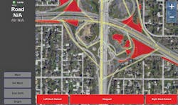
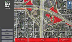
Figure 1. A live map of a highway showing what an operator views on-screen in an automated vehicle location unit, with noxious weed patches identified in red.
Just like in the snow
Trisha Stefanski, MnDOT Metro District Asset Management Engineer, brainstormed with others at MnDOT for ways to overcome these challenges. “We became excited at the concept of improving mowing operations through a well-established technology,” Stefanski said. “[AVL’s] simple automated exchange of data to and from the mower operator, while in the field, would mean smarter mowing, less impact on the environment and cost savings for the public.”
AVL is a powerful tool that can benefit the performance, quality and safety of vehicles and services. In farming, AVL has helped to decrease chemical usage on crops. Trucking and freight industries use it to strategize operations and effectively route vehicles. MnDOT already possessed some familiarity with AVL technology, so it was a logical yet perceptive step to see if it had any value for mowing.
MnDOT has and continues to use AVL in snowplows for winter maintenance activities. These systems provide real-time data including vehicle location, road surface conditions, plow position, material application rates and temperature readings. The snowplow systems include AVL units, sensors, communication equipment and complex data management. Data is collected through an in-vehicle controller unit that enables the automatic production of operational reports and provides alerts. By mimicking the concepts behind MnDOT’s snowplow AVL setup and recognizing that mowing could benefit from a similar solution, the idea for a pilot project was formed.
Operator input
There are numerous brands of AVL systems, each possessing their own unique data storage and transfer methods. For this project, MnDOT selected the AVL hardware they also use in snowplows: Ameritrak AT-500. Along with utilizing the same hardware used for winter maintenance, the project also applied several years worth of GPS-located noxious weed data that had been gathered by MnDOT. This data would emerge as a key element of the project. Prior to launching this effort, several goals were formulated, including:
- Developing the user interface;
- Establishing data exchange processes;
- Creating viable reports and usable maps;
- Developing a training manual and program; and
- Quantifying noxious weed and herbicide changes.
Like its use in snowplows, the AVL system needed to track mower locations. But instead of tracking controller data, it was planned that operators would input the deck status and other key information through an on-screen interface. This approach simplified the pilot project from a software design standpoint. Operators needed to know the location of existing noxious weeds and be able to mark newly discovered patches. From the acquired data, maps and reports could be generated for supervisors. This information could be used to create tactics for more efficient operations.
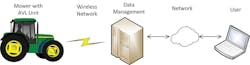
Figure 2. Data flows from the AVL unit to Ameritrak on a secure network and then to MnDOT servers for use and analysis.
Putting it all together
The first task was developing the user interface. This required several iterations of collaborating with Ameritrak to refine the software. These iterations were critical to producing a user-friendly interface and tailoring data outputs to match field activities. The mower software application was developed with usability in mind; operators had to be able to quickly identify their current location and avoid noxious weeds ahead of a mower’s forward progress. The live map pictured in Figure 1 shows what an operator views on-screen; noxious weed patches are depicted in red. Operators use the buttons at the bottom of the touch screen to enter other data, like deck status and shift information, when appropriate. The interface also provides options for operators to view weather radar. This keeps them aware of changes in meteorological conditions such as approaching storms.
The next challenge was establishing the structure of the overall system. The means of data communication from individual AVL units to MnDOT servers is an AirCard that provides Internet access. The AirCard draws power from the AVL unit and can remain installed during winter storage of the mowers. Data flows to Ameritrak on a secure network and then to MnDOT servers for use and analysis. Figure 2 loosely depicts the exchange of data within the system.
With the interface under development and data exchange procedures in place, MnDOT procured the hardware. AVL units were installed in 30 mowers during 2015 and 2016. Mechanics established an installation process, focusing on placing the screen in practical locations and ensuring hardware was sufficiently protected. They constructed a customized metal rack for the AVL unit and other components. The unit was mounted directly onto the sheet metal for protection and stability. For the operator interface, a mounting unit with a touch screen was attached to the rack. Wiring would be installed that tapped into the mower’s battery to power the system. Because there were different makes and models of mowers within the fleet, installation was customized depending on cab layout and space constraints.
Developing useful reports from collected data was the next step. Several reports could be created, but the accomplishment report was MnDOT’s priority. Upon completion of a workday, an accomplishment report can be generated by the operator, supervisors or managers that summarizes the duration of time that a mower was active, the number of acres mowed and miles traveled with corresponding GPS coordinates. Additionally, “bread-crumb” GPS coordinates of a mower’s path can be viewed using Google Earth.
“With very little operator interaction, we are now able to get automated reports containing detailed and accurate information on where, when and how much is being mowed,” Stefanski noted.
With processes established and reporting in full swing, MnDOT focused on documenting the initiative so the project could be expanded and replicated in the future. An operators’ manual and troubleshooting guide were created based on the challenges and successes of the initial rollout. These are living documents that will evolve as discoveries and issues arise. After incorporating AVL in the 30 mowers, training was provided for supervisors and operators to help them understand usage and benefits of the system. Going forward, training sessions will be offered prior to each mowing season or as needed for new employees.
Looking forward to more time
It was beneficial to do a pilot project to determine how AVL devices would operate and confirm that data could successfully be transferred from external servers to internal MnDOT servers. Due to the IT components of the project (i.e., data exchange, software coding), implementation was more complex than originally envisioned. Despite these intricacies, supervisors and superintendents were supportive and understood the potential benefits of the project. This resulted in a positive side effect of some MnDOT employees becoming more technologically savvy.
Iteratively refining the interface with Ameritrak was necessary and beneficial, but it took time. This limited the amount of data collected during the 2015 and 2016 mowing seasons. MnDOT hopes to gather data over the next two years with the full AVL-equipped fleet. This should provide enough information to better determine how AVL can help reduce weeds and pesticide use on MnDOT roads.
It has been challenging to apply software updates to AVL units. Not all upgrades can be pushed out remotely. Therefore, software updates can temporarily remove a mower from active duty. Greater planning will be employed to limit the impacts of updates on operations.
The hardware was purchased toward the end of a technology cycle. New, upgraded hardware has since been developed that is more compact and faster. Technological advancement is inevitable and always comes into play during innovative projects. MnDOT will continue to consider future upgrades and attempt to plan for software and hardware improvements.
This project had a one-time cost of $110,000 (not including MnDOT staff time). Ongoing costs are roughly projected to be $11,000 per year, considering only the 30 AVL systems currently in operation. Specific project outcomes included, but were not limited to:
- Generating a protocol for AVL installs, training and troubleshooting;
- Reducing paperwork by automating accomplishment reports;
- Better tracking of mowing needs and level of service;
- Decreasing the spread of noxious weeds and herbicide use; and
- Optimizing mower routes.
By employing AVL technology, MnDOT took a forward-thinking approach that stepped outside the boundaries of traditional mowing. So far, the project has been successful, and MnDOT hopes that collecting data over another mowing season will help to show real savings in herbicide use.
In the meantime, MnDOT is already considering ways AVL technology could enhance other maintenance activities.
“What I really like about this project is that we are taking something commonly used in snow plows and other vehicles—cars, shipping trucks, etc.—and we’re putting it into MnDOT maintenance mowing operations,” Stefanski said. “And if this project continues to be successful, we can look at utilizing AVL for pavement repair equipment, street sweepers and other vehicles. I am also certain we will come up with additional uses for the AVL in mowing data that we have not thought of yet.”
For more details on AVL in mowers, please visit MnDOT’s web page for this research project at:
http://dotapp7.dot.state.mn.us/projectPages/pages/projectDetails.jsf?id=13625&type=CONTRACT.