Incident Corridor Management System Q&A with North Carolina DOT
Last month, the North Carolina DOT (NCDOT) announced it would be activating an innovative signal system in the Asheville area designed to guide drivers around major incidents on I-26.
NCDOT crews have installed signs and upgraded signal systems along I-26 alternate routes such as Asheville Highway and Hendersonville Road as part of its new Incident Corridor Management (ICM) System. Traffic & Transit (T&T) had a discussion with NCDOT representatives about this signal system. The following is an edited conversation with Chad Franklin (CF)—Regional Information & Traffic Systems Engineer; Jennifer Portanova (JP)—State Systems Operations Engineer; and Matthew Carlisle (MC)—State Signal Systems Engineer.
T&T: Can you talk about the need being addressed with this signal systems project and how it benefits this particular corridor?
JP: So this is a widening project on a major interstate in our state, so when we’re talking about widening the interstate, we’re talking about barriers, narrowed lanes, some conditions that we don’t typically have. So the premise behind the project was when there’s an incident in this area, and we expect there’s going to be conditions that might create more incidents, we want to be able to better manage those incidents. So we have strategies like quick clearance, where we’re trying to clear the road as fast as possible so we don’t have backups when there’s an incident. And when it’s harder to clear those incidents, we have other strategies, like traffic management strategies to better manage the traffic. And that’s the signal timing aspect of this: if we have to detour traffic off the roadway, we’re going to use other parts of the roadway network to better handle that load.
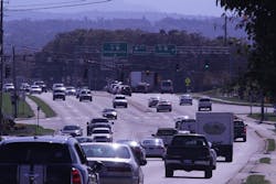
CF: I-26 is a very heavily traveled vacation route through our area. We’re becoming more of the target location to come to—if you’re going to Myrtle Beach and you’re from Ohio, you travel I-26. It’s probably more of a major commercial route than anything in the nation. So it was a four-lane facility to begin with, with all of our detour routes being commuter routes throughout the day, which carries up to 50,000 cars a day along our routes that run parallel to I-26. So we knew if there was any issue now, everybody traveling along I-26 would jump off and completely clog up our secondary routes.
T&T: Can you talk about the technology behind the Incident Corridor Management System?
CF: We were actually fortunate getting our first citywide. NCDOT put in a major signal systems project: started the design about four years ago, started the project about three, and it was finishing up as part of the regional response to the project. Luckily, this was a huge part of that project—the signal system project. But it’s two different divisions of the DOT—Division 13 and 14. So the signal system project was in Division 13. We were able to reach out and get some of the Division 14 signals as part of the regional project, which made this technology communication much easier.
MC: In addition to all the ones that we were already getting online in Division 13, I think we upgraded 83 signals in Division 14 as part of the ICM project—upgraded so we can have it communicate with our statewide signal system.
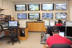
JP: Other technologies we are using to implement this are overhead message boards and messages. So there’s a travel information piece and then there’s a signal system piece. And of course our travel information goes out to all the navigation companies, and we send out an event in our system that goes out to our navigation companies. So that’s the integrated part. There’s a centralized signal system software that runs all these signals. There’s timing plans that are pre-programmed in there, where we call up action sets to turn on the timing plans, and we call up message sets to turn on the messages that all coordinate together. And the way we coordinate those together has been a decision matrix pool that we’ve developed. Two years ago, when we thought it was going to be really simple, simple became complex because we had to integrate it all together, and we had to develop some tools to do that. Implementing is not the engineers that develop it, it’s an operator sitting in the TMC, and they have to call up all these different components, and they need to know the answer. They need to know what plan they are trying to display. And so we created all the tools to make their job easier, to find the right answer. So those tools took some time. Our simplistic idea—and I call it our Easy Button, where somebody can just hit an Easy Button, and all the messages display, all the timing plans come up. Creating the Easy Button took a lot of engineering work to prepare. It took two years to develop timing plans for all the signals and all the routes; two years to develop all the response plans to go together.
T&T: Can you talk about the various challenges that came with developing this system?
CF: First of all, it’s two different Divisions. You’ve got five different law enforcement agencies involved in the route. You’ve got six different fire agencies, two different cities. There were a lot of communication bridges that had to be gapped to understand what we want to do. If we don’t engage with the public and our emergency response partners—if they don’t understand how it works, that’s a major issue when we implement the plan itself because it’s such a vast communication gap among other agencies as well.
JP: Some other things were brand new that we had never done before like changeable trailblazers; we had to make those work.
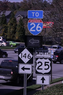
MC: Typically we have what are called static trailblazers around freeway interchanges; you have a route shield, in this case on I-26, with just a static arrow panel underneath, pointing either left, right, or straight to guide you to the nearest place to get on that freeway. And so in this instance, because we wanted to have the ability to change and adjust driver behavior when we are implementing these alternate and detour routes, we have actually swapped out some of those static arrows to LED panels. And so 99% of the time, during regular daily operations, that arrow points the same way that the static arrow has always pointed, but we have the capability to remotely change those arrow directions when we implement these alternate or detour routes so that we are not guiding traffic right onto the freeway where we have a closure or 3-mile queue or something like that. It’s also used for when we are telling traffic to get off the freeway to get them around an incident, that we take them all the way past an incident before we bring them back onto the freeway. And they’re operated by our traffic signals.
JP: Another big hurdle that we had was that the Asheville area was not on our state network, our IT network like the rest of our TMCs are because there was no TMC that was in that area before this project. There was an unofficial one, and the regions handled their devices. But all the rest of the TMCs in the state are connected onto the DOT IT fiber basically. So what we are doing with this project is getting this technology, including the signal system, onto the same network that the rest of the state’s on. So that was a big hurdle, but necessary. And it’s going to make us more efficient in the long run because we’ll be more redundant across the state and be able to operate from anywhere. Because we had not done this before, we were developing tools and trying to figure out the best, most efficient way to engineer this. And so sometimes one of your first projects becomes your longer ones because you’re discovering. Some other challenges that make this a little different is because it’s not necessarily the most urban area, but it’s not necessarily the most rural area. So it’s a unique example of how we do ICM, because typically when you see ICM around the country, you see the most urban areas who are using those concepts; whereas in North Carolina, we’ve adapted those concepts in less urban areas like this. So we had to make changes and adapt to those conditions.
T&T: Can you talk about some examples where this system helps to get motorists to alternate routes?
CF: We’ve looked at several different scenarios to try to come up with them. We do have the ICM message board posted on I-26 and our secondary routes—that’s going to relay that information as far as wrecks or crashes to the people ahead of time. But we also have along I-26, I-40, and secondary routes, we placed static signage for incident routing around any traffic congestion. So the static signs are already in place as far as if they come up on traffic; and prior to every ramp, we have I-26 incident bypass signs where people can get off and go around. But with secondary roads as congested as they are on a normal day, we don’t want to push anything until there’s a complete closure at that point, and then we’ll advertise the ICM routes as well.
MC: So what we’ve done is we sat down all the pertinent stakeholders and decided based on specific incident details, how would we react? What routes would be used? What signal timing would be used? That kind of stuff. And once we made those decisions, we put it into our ICM response database. So this database is what the TMC operators are actually going to during an incident to determine how they need to react. So they go into this database, and they put in all the various parameters of an incident, like where is it, what direction is it? What time of day is it? What day of the week is it? How long do we think it’s going to last? How many lanes are closed? And based on all those inputs, they get a set of outputs. And those outputs would include what route we’re using, a list of all the dynamic message signs and changeable message signs that we need to turn on, and what messages go on those signs. It would include a list of all the signals and what timing plans need to go in on those signals. It would include turn-by-turn directions that we can push out to our DriveNC website. I think we also push those to some other places, then include a list of all the contacts for tow truck companies, if we need to get a contract tower as well as maybe some other people that just need to be notified when we have this type of incident. As far as both the signal timing and the message sets, the signing piece—they don’t actually have to go to 12 different signs and type up all these messages; we have pre-created message sets. So they essentially just click a button, and it puts the right messages on all the right signs. And same thing with the signal timing. They don’t have to manually turn on the timing on all these individual signals. They just click a few buttons on our signal system software, and it pushes the proper timing plans to all the right signals. So it’s as close to an Easy Button as we have right now, and it’s vastly superior to other ways of doing it.