How to protect roads from floods
The Red River Valley of western Minnesota and eastern North and South Dakota has a flooding problem: It happens all the time.
Instead of rebuilding the land, roads and bridges after every flood, communities and government agencies are trying to find ways to mitigate damage and allow life to return to normal more quickly after floods.
Protecting Roads From Floods Starts with Construction
One area of change is road construction. Researchers at the University of Minnesota are working with engineers from the Minnesota Department of Transportation (MnDOT) to develop methods of protecting roads by building embankments that resist washing out during floods. University researchers built a facility to study this particular problem at the University of Minnesota’s St. Anthony Falls Laboratory, a leader in interdisciplinary fluid mechanics research. With a long history of cutting-edge research and large-scale modeling, St. Anthony Falls Laboratory is perfectly equipped to conduct full-scale road embankment studies. Situated next to the Mississippi River on Hennepin Island, the laboratory has the capabilities to conduct a wide range of hydraulic experiments using the natural hydro-power of St. Anthony Falls that could provide answers to current and future flooding problems in the valley and, potentially, worldwide.
Road Flooding Red Alert
With its newly constructed facility designed for road-embankment overtopping, St. Anthony Falls Laboratory is studying flooding that occurs in areas of minimal topographical variation. The Red River Valley of western Minnesota and eastern North and South Dakota is one of the best examples of flooding in an exceptionally flat region. The Red River has several characteristics that make its flooding unique. It flows out of its bank frequently, on average once every two years. A number of features contribute to the frequent flooding in the Red River Valley. While urbanization, which creates more runoff, is a contributing issue, natural characteristics of the river and region are primarily responsible.
Geologically speaking, the Red River Valley is young, about 9,300 years old. The Red River Valley was once the bottom of a giant glacial lake, Lake Agassiz, and has not had nearly enough time to cut a deep channel that would contain the river. When the river overtops its banks, it easily spreads across one of the flattest landscapes in the world, the bottom of Lake Agassiz. The flatness of the valley in combination with a decreasing downstream gradient create ideal conditions for flooding to occur.
Near Fargo, N.D., the Red River drops, on average, 5 in. every mile, but by the time the river nears the U.S.-Canada border, its slope flattens substantially, averaging only a 1.5-in.-per-mile drop. Another unique and troubling feature of the river is it flows north. Spring runoff from the watershed begins at the headwaters in the south and proceeds northward. At the same time, increased river discharge from the headwaters spring thaw move northward and merge with more recent spring snowmelt downstream. The river’s north-flowing system also is more likely to create ice jams, because ice breakup begins in the south and flows northward, where ice is likely more intact. Ice jams reduce the volume of water that the river can pass, which causes water to back up and overtop the riverbanks.
Another attribute that makes Red River floods unique is the rate of flood events. The flatness of the Red River landscape causes floods to vary stage height slowly and persist longer. River stage rises to its peak, inundates the surrounding land and recedes to normal levels over the course of days, if not weeks. In regions with more dramatic topographical changes, flood events are quicker, as floodwaters rise and recede in a matter of hours or days during very large events. The landscape’s flatness also causes shallow and widespread flooding. Affected areas are typically only underwater by a foot or so, but the area is massive and the flooding can have catastrophic impact.
Widespread and slow flooding causes tremendous damage to roads, lives and property. Given the frequency of Red River floods, continually repairing and rebuilding every year is terribly expensive. In the Red River flood of 1997, floodwaters reached, at the widest, more than 3 miles inland near the Grand Forks and East Grand Forks communities, resulting in $3.5 billion in total damages in the Red River region. While the 1997 flood was a major event, some roads like Highway 1 near Oslo, Minn., are overtopped and extensively damaged on a near-yearly basis. According to university research engineer Craig Taylor, “It is not uncommon for one overtopping site to have a half-mile-long stretch of road being damaged.”
Repairing the same half-mile stretch of road every year or every other year is expensive and causes difficulties for some communities as they wait for roads to be repaired after the floodwaters recede. One way to fix this issue would be to raise the elevation of commonly overtopped roads, but as MnDOT Assistant District 2 Engineer J.T. Anderson explained, “We can’t just raise the road because it would create backwater upstream.” A potential consequence of creating higher upstream backwater is flooding areas that previously remained dry during floods. Anderson said, “Our best bet is to let the water overtop the road and try to protect the road when it does.”
Protecting Roads from Flooding
The University of Minnesota’s St. Anthony Falls Laboratory, with support from MnDOT and the Minnesota Local Roads Research Board, is conducting a new style of experiment to determine the best methods of protecting roads when they are overtopped. Taylor thought, “Unlike really high-depth, short-duration events, where you can only protect an embankment with concrete and boulders, roads in the Red River Valley may be protected from longer-duration, low-depth floods using soft armoring, reinforced vegetation or temporary techniques.”
Taylor, other university researchers and MnDOT hope that full-scale modeling of scour prevention and erosion-control techniques will lead to an understanding of which protection method works best under which conditions. Techniques currently undergoing testing include embankment scour-prevention products such as turf-reinforcement mat, turf-armoring mat and matrix riprap. Three other erosion-control techniques—reduced slopes, a rubber liner and a water tube with apron—also will be tested. Typically, testing these methods involves flowing increasingly higher-velocity water across it until either the material is destroyed or the anchoring method fails. This type of testing results in a sheer-strength rating, which is more applicable in long flat applications with few transitions. Roads and their embankments are usually shorter segments of land with multiple transitions and grades. A sheer strength only partially helps in understanding the effectiveness of a particular method.
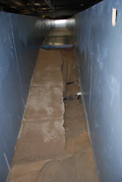
In an attempt to gain a more complete understanding of each method’s effectiveness, researchers at St. Anthony Falls Laboratory are modeling the real-world problem as closely as possible. They have built two experimental full-scale flume facilities that simulate a two-lane road. The most problematic roads in the valley are east-west roads that cut across the flat prairie or farmland of the region.
The Red River flows out of banks, and water collects and ponds on the south side of east-west roads. If the flood is high enough, the water will flow across the hard asphalt surface of the road. In this situation, the water scours and erodes the north embankment until it begins to erode underneath the road surface. Eventually, the leading edge of the asphalt crumbles and the erosion continues backward in this pattern until the road is completely washed away. From this point, water continues north across the next flat farm field until it comes to another embankment or the flood recedes.
The design of the experimental flumes mimics how floodwaters in the Red River Valley collect on the south side of an east-west highway until they rise enough to spill over the crown of the road. For this reason, the flumes replicate a 3-ft cross section of road. The perspective is from the south side of the road looking north across the road. The near lane slopes slightly up to the crown of the road with the far lane sloping down onto the embankment.
These facilities share a common tank where water ponds. Water ponds in the tank until it reaches the level where it begins to overtop the road. Once the water is deep enough it flows across the far lane of the road and down an embankment of either a 4:1 or 6:1 grade depending on the flume. After flowing down the embankment, water flows across a flat area, representing a ditch before draining away. These flumes have the capacity to discharge 20 cu ft of Mississippi River water per second. Any combination of soil types, erosion-control products or embankment-protection techniques can be installed and studied in these flumes.
The main objective of this study is to obtain a better understanding of how and when scour prevention and erosion control work. According to Taylor, “These methods have been deployed in the field, but you never really know under which conditions they survived or failed. We would like to be able to put together a method-effectiveness and optimal-situation guide for each technique we test.”
Hopefully, a guide of that nature will allow transportation departments to construct roads that will survive most overtopping events. All of these techniques have the ability to protect roads. The permanent products such as a turf-reinforcement mat, turf-armoring mat and matrix riprap have promise in reducing scour and erosion through strengthening and protecting the soil.
Protection methods such as reduced slopes, rubber membrane and a water tube with apron may be able to dissipate the destructive energy of the water by adapting the flow or position of the hydraulic jump in the least damaging area.
Potentially, a combination of these methods may be the best. St. Anthony Falls Laboratory researchers hope to discover an effective system for protecting roads in flat regions. Successful protection methods would save public funds, allowing for other projects instead of repairing the same roads every few years. If roads are not washed away, they can act as flood protection for areas downstream by holding back floodwaters until the river recedes. Perhaps the biggest winners would be the residents who only need to wait out the floods and not an annual repair of the roads they rely on.