How Colorado DOT manages and mitigates rockfall events along roadways
In a state like Colorado, where many of the roadways can be found traversing through majestic, mountainous terrains, transportation officials expect rockfall activity to make the occasional impact to state roads. Such occurrences are, in fact, almost unavoidable.
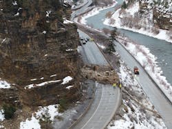
Back in early February 2019, a large rockslide fell onto I-70 in Glenwood Canyon in Glenwood Springs, Colorado, closing down the interstate in both directions. The slide occurred around 1 a.m. on the morning of Tuesday, Feb. 5, just west of the Grizzly Creek rest area.
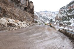
By daylight, Colorado DOT (CDOT) crews were out on I-70 assessing the extent of the rockfall and any damage done to the infrastructure. In this particular location of the interstate, the road decks for the eastbound and westbound lanes exist on two different levels, with most of the rock hitting the westbound deck. Some damage was done to the parapet wall standing along the westbound deck, and the rockfall also punched a few holes into the asphalt pavement, according to CDOT officials.
Fortunately for CDOT and the motorists traveling along this corridor, the extent of the damage was not significant enough to warrant extensive road closures. CDOT crews were able to reopen the eastbound lanes just before 6:30 p.m. that day and opened one westbound lane later that night. The total amount of rock was estimated to be between 250 and 300 tons. “So if you break that down, one of our dump trucks would haul out one ton of rock,” Tracy Trulove, Region 3 Communications Manager for CDOT, told Roads & Bridges. “It was a significant amount. And we were lucky on this one that it didn’t do a great deal of damage to the highway.” Trulove went on to explain that repairs took another few weeks for major fixes to the damaged parapet wall, but that crews had put a temporary barrier in place in order to keep traffic moving.
On Feb. 5, 2019, a large rockslide fell onto I-70 in Glenwood Canyon in Colorado. The slide occurred around 1 a.m., just west of the Grizzly Creek rest area. By daylight, crews were assessing the extent of the rockfall and any damage done to the infrastructure.
WHAT'S THE GAME PLAN?
On the rare but inevitable occasions when a rockfall incident in Glenwood Canyon may occur, CDOT has standard protocols in place to respond to such events. This starts with maintenance crews rolling out an incident command structure where the team begins the evaluation of the site. CDOT engineers would then assist in whatever immediate repairs are needed along the impacted highway.
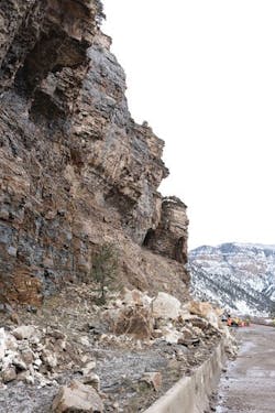
When it comes to situations where more extensive assessment of a particular slope is required, CDOT brings in a specialty unit from its geohazards program. In the case of the February 2019 rockfall occurrence in Glenwood Canyon, the geohazards team assisted the maintenance team in determining whether or not the road could be reopened to traffic. The team also determined the need for some rock scaling for this incident, which involves the removal of loose rock from slopes. “[It wasn’t] so much because the rockfall left a really unstable condition,” Ty Ortiz, CDOT geohazards program manager explained to Roads & Bridges, “but because the rockslide left a lot of loose rock that was residual from the slide, and we wanted to remove that rock so that we didn’t have residual, smaller, 4- to 6-in. rocks come down and hit cars.”
While the maintenance and geohazards teams conducted their evaluations of the rockfall site on I-70, the CDOT communications team was working hard to get information out regarding the road closures in order to inform travelers about traffic conditions along the corridor. The eastbound lanes on I-70 were closed down from 1 a.m. on Feb. 5 until about 10 a.m. that day. According to local reports, however, those lanes were closed down again for mitigation efforts around 3:30 p.m. and then reopened by 6:30 p.m. It was another story for the westbound lanes, which did not open back up until 9 p.m. “With the westbound closure, we had to bring a crane in to do some more scaling,” Trulove said. She also explained that though they have alternate routes available, the best one takes motorists on a detour about four hours out of the way. “And so folks were really having to take the alternate route around. And the challenge when we’re still in winter is that those alternate routes are usually our two-lane, smaller auxiliary highways, and we had [wet] weather that day. So it poses a challenge to motorists trying to get around that kind of incident.”
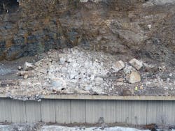
Much of the repair work on Feb. 5 involved removing much of the debris along the roadway, most of which was moved onto the shoulder rather than trucked out. Then, in addition to installing the temporary barrier in place of the damaged parapet wall, crews worked to patch holes and large divots in the afflicted pavement using cold-mix asphalt. After the westbound lanes opened up, CDOT continued to work with an emergency team contracted to repair the parapet wall and continue debris removal. By the end of winter, CDOT crews were able to go back and haul the rest of the rock left on the site.
Some damage was done to the parapet wall standing along the westbound deck, and the rockfall also punched a several holes into the asphalt pavement. The total amount of rockfall was estimated to be between 250 and 300 tons.
MANAGING HAZARDS
The geohazards team at CDOT monitors around 750 rockfall sites across the state, including that of Glenwood Canyon at I-70. “In Glenwood Canyon in particular, when we do have rockfall, we see some pretty big ones,” Trulove said. “I bet in the past 15 years, there’s been four very significant [incidents] that have caused roadway damage.”
On the occasions where CDOT maintenance crews need help in determining the safety of the motoring public after a rockfall event, the geohazards team is called in. This team employs geologists and engineers that primarily specialize in rock slope evaluation and slope stability. After an event such as the one from Feb. 5 occurs, a member of the team goes out to the site in order to find the source of whatever caused the rockfall. The investigation from the geohazards team may involve taking slope measurements which could include the slope angle, the characteristics of the rock, the extent of the fracturing within the rock, and the spacing of that fracturing. Depending on the findings, the geohazards team may determine the road is safe to open back up to traffic, or may recommend rock scaling or some mitigation work before allowing traffic to pass through the affected area.
Some of the evaluation methods for the geohazards team have evolved over the past few years as the team has begun to implement new technology to conduct inspections. “What we used to do a lot is climb,” Ortiz said. “We would climb all over the place, we would climb up to the slope and look at it. And it’s not that we don’t do that anymore; we still do quite a bit of that. But now we can use a drone.” For the incident on I-70, Ortiz explained that someone contracted with the geohazards team was able to get out to the site and capture some images using a drone. This led to the team having the ability to quickly and easily find the source of the incident. It was that surveying work with the drone that allowed the geohazards team to determine they needed to do some rock scaling.
In the Glenwood Canyon event, Ortiz estimated that the largest chunk of rock that fell onto the roadway was probably around 8 ft in diameter, which he said is pretty common for a rock that size to fall in Colorado, though not necessarily in Glenwood Canyon. “That size of a block will hit the road somewhere in Colorado I would say quarterly,” he said.
One of the biggest challenges for the geohazards team is removing the rock from the affected roadway. “You could imagine a 40-ton rock is hard to move or get off the road with the size of equipment typically used by a geohazards team,” Ortiz said. “So in this particular case, we have a blasting crew in that region. So they drilled and shot the rock into bite-sized pieces that could be removed a little easier.” Blasting rock into smaller chunks takes some time for crews to complete and requires that the road remain closed during the process. Much of the smaller pieces of rock were then moved into a ditch in order for traffic to reopen. The rock would eventually be moved from the ditch to a disposal site.
When it comes to the cause of rockslides like the one that occurred in Glenwood Canyon, certain weather patterns and rapid temperature changes over short periods of time can contribute to a greater chance of a rockfall incident. The springtime is when Colorado typically sees the most rockfall occur due to the varying temperatures and precipitation events experienced in the area. “You could have a 60°F day in the canyon, and then you could fall below freezing at night,” Ortiz said. “And you could have that every day—you could have above and below freezing temps, a freeze-thaw cycle that occurs daily. So the additional moisture combined with more freeze-thaw cycles, that’s what causes springtime to be much more of a rockslide-prone season.”
In the case of the I-70 event in February, Glenwood Canyon experienced a significant rain event soon before the rockslide occurred, which Ortiz says is most likely what triggered the failure of the rock slope. In addition, long-term weathering of the slope caused by temperature fluctuations creates fractures in the rock. Furthermore, the rain event may have filled up cracks in the rock with water which may have frozen overnight. “You get below freezing at night, and so you get this ice-jacking effect—where water in the crack will freeze and expand,” Ortiz said. This, he explained, can lead to fracturing in the rocks, a possible indicator of a slope’s instability.
At press time, another rockslide had occurred on I-70 in Glenwood Canyon on the morning of May 21. Local reports indicated that wet weather in the area led to several loose larger rocks falling onto the roadway below. While no vehicles were hit by the rockfall, the slide did cause some damage to a concrete barrier along I-70.
Much of the repair work for the February rockslide involved removing much of the debris from the roadway, most of which was moved onto the shoulder, plus installing the temporary barrier in place of the damaged parapet wall.
WHAT CAN BE DONE?
When it comes to preventing or mitigating the impacts of rockfall to Colorado roadways, CDOT is already doing its part. In Glenwood Canyon alone, the department has placed roughly 30 rockfall fences, or rockfall barriers, in the area. However, the placement of the fencing is based on the frequency of incidents in the area, and the stretch of I-70 that experienced this particular incident had not seen much active rockfall prior to February. Additionally, rockfall fencing cannot be placed along the entire canyon.
“Quite honestly, it’s about an 18-mile stretch of highway that just has beautiful cliffs on either side,” Trulove said of Glenwood Canyon. “And it’s not the only place in the state where we see that. But the challenge is there’s just a huge amount of our highways that run along rockfall areas. And the prevention we do is determining where we could put rockfall fence in and where it makes sense to do that. The challenge we have is there are many areas around Colorado—because we’ve got mountains everywhere—that it happens. And there’s just so much you can do.”
CDOT continues to support innovation and further research within the geohazards program to explore alternative approaches to rockfall mitigation. With the use of drones, the geohazards team at CDOT can collect photos relatively inexpensively and obtain laser scans of rock slopes. In addition, three-dimensional models can be created from the photos and scans to study the slopes more thoroughly. Ortiz explained that capturing images of the slope at different times can help the team compare the images while taking a look at where rockfalls occur. “Now we could start focusing our efforts a little more directly to areas that might be more susceptible to a future failure,” Ortiz said. “That’s one of the more exciting things that I think is happening within the geological engineering world these days.”
A direction the geohazards team is moving in involves taking the scans obtained from the drones and combining them with data in order to begin finding commonalities between various rockfall events. “With the data that we can get from the slope scans, we can find if there is an amount of movement or a type of precursor rockfall event associated with a larger rock failure or landslide,” Ortiz explained. That data combined with weather data, the geology of the slope, and other related factors could potentially help CDOT understand more about patterns connected to rockfall.
Moving forward, the geohazards team is planning to rely more heavily on the use of the various technologies at their disposal in order to more proactively respond to data on slope conditions rather than responding reactively to rockfall events. “Down the road, we might be able to get to a forecasting method, which you’re not necessarily predicting what and when, but you’re making a determination based on actual evidence,” Ortiz said.
----------
All photos courtesy of Colorado DOT.