Information on the fly
A toy looks out of place in a study. That is definitely the case in the home, and it is not a common look in the world of academia, either.
Unmanned aerial vehicles (UAVs), part of a hobby trend just a couple of years ago, are at the cusp of graduating into the business world, as state departments of transportation (DOT) begin to explore the benefits of capturing images of varying degrees from a couple hundred feet off the ground. The DOTs in Michigan, North Carolina and Ohio are already building platforms around the potential of UAVs, and many more agencies are sure to follow. So far the devices are passing with flying colors.
“I thought this was a game changer when I first saw the thing flying around,” Steve Cook, who heads the operation and management of UAVs at the Michigan DOT, told Roads & Bridges. “Out of the block, talking about transportation and roads and bridges, this is a game changer. It really is, if we can get over two of the major stumbling blocks.”
The hope is those blocks are not booby-trapped, but you never know when you deal with the federal government and the traveling public. The Federal Aviation Administration (FAA) is currently No. 1 on the obstacle list, as anyone who wants to operate a UAV must now submit paperwork to the federal agency in order to receive clearance—or in this case a Section 333 exemption and/or a certificate of authorization (COA). The operator must be trained to fly UAVs, and the exemptee must explain to the FAA exactly how the apparatus will be used. The approval process can take a while. For the Michigan State Police, it took about eight months. The FAA is in the process of solidifying UAV regulations, so over the course of the next year the picture should be clearer—and possibly a lot more stringent.
Public perception is the second concern. DOT officials are afraid the sight of several UAVs in the air would create massive traffic disruptions and generate a fear that someone is always watching—the Big Brother Effect.
Still, despite the issues, some state DOTs can’t get on board fast enough even though the territory is still an unknown. The approach, however, is still a cautious one.
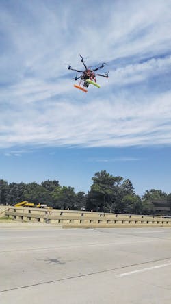
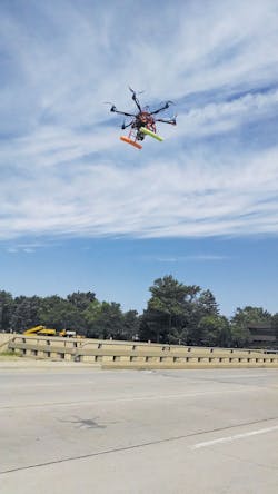
A Bergen hexacopter armed with a Nikon D800 digital SLR 36-megapixel camera would scan 600-ft stretches of the road from a height of 80-150 ft. Each scan would take about 30 minutes to execute.
Gravel roads pave way
Colin Brooks is a senior research scientist for the Michigan Tech Research Institute. His background is in remote sensing and GIS, and his area of expertise is in satellite imagery analysis, aerial imagery analysis and integrating geospatial data.
The U.S. DOT first approached Brooks to do environmental assessments on highway bypasses and look at vehicle crossing times at international borders under the agency’s Commercial Remote Sensing and Spatial Information Program. In 2011, the U.S. DOT became interested in doing remote sensing with UAVs, and Michigan Tech, under Brooks’ leadership, submitted a proposal to evaluate using UAVs and regular fixed-wing aircraft to assess unpaved road conditions. The U.S. DOT selected the spec, and Brooks’ team got to work assessing different platforms to collect extreme high-resolution unpaved road condition data.
“I had a lot of experience with different sensors and platforms from aerial and satellite data,” Brooks told Roads & Bridges. “We started flying some short segments of gravel roads and saw that we were able to collect overlapping stereo imagery where we could create 3-D data with resolution better than 1 cm, which is more than we needed to be able to automatically detect and characterize potholes, ruts, washboarding and crown sufficiency.”
Surveying an unpaved rural road in southeast Michigan with a Bergen hexacopter (six blades) armed with a Nikon D800 digital SLR 36-megapixel camera, Brooks and his team would scan 600-ft stretches with the UAV flying 80-150 ft above the road. Each scan would take about 30 minutes to execute—20 minutes to set up the equipment and 10 minutes of fly time. Brooks prefers the six-blade UAV because it is easier to fly over longer distances and can carry the weight of a professional digital camera.
Steve Cook over at the Michigan DOT heard about Michigan Tech’s work with the U.S. DOT and was eager to discover the dimension UAVs could offer at the state level. So the agency put out a request for proposal calling for a two-year research study on the use of UAVs across various forms of infrastructure. Michigan Tech submitted the winning bid, and went right to work on several different demonstration applications. The biggest and most convincing one involved the 96 Fix project. With the 7-mile stretch of interstate closed to traffic for six months, Michigan Tech was able to scan two of the 37 bridge decks under construction, and also flew the UAVs underneath to check the substructure. According to Brooks, the UAVs also carried a thermal camera and a small LiDAR camera to create a 3-D model.
“This thing flies over, makes a couple of passes [over the bridge deck] and takes very fast pictures. They stitch it together on the back end, and you can use that for current asset management to see how the bridge ages over time, or you can see delaminations and potholes,” said Cook.
“[The bridge scanning] was interesting because we tested three different types of sensors,” Brooks said. “This provided an ideal situation for us to demonstrate how UAV technologies could be used in the near future.”
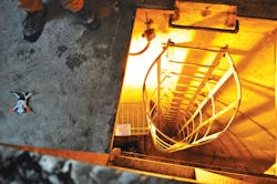
The research project also highlighted a unique situation. The interstate system around Detroit is prone to flooding, so large pumping stations are used to make sure heavy rainfall does not cripple traffic. The pumping stations are in confined areas underneath the interstate, putting workers at risk when the time comes to inspect the pumps. Michigan Tech used a mini-UAV, one that fits in the palm of your hand, to go down and take video of the pumping stations.
“We got some great video and we were able to show how we could take a look around before you put a person in there,” said Brooks. “The opportunity to increase safety was definitely a focus for MDOT.”
Michigan Tech also used a traffic-monitoring blimp to take real-time video on U.S. 23 in Ann Arbor and at Belle Isle during the ITS World Congress, which was held in Detroit last September. The Michigan DOT set up a mini traffic-operations center on the show floor at the ITS World Congress, showing the work of UAV technology first-hand.
A mini-UAV (shown) was used to evaluate pumping stations near Detriot’s interstate system.
Of course, you need a place to put all of this productivity, and the amount of data generated from this new technology has been a concern for the Michigan DOT, which is why the agency will be conducting a second phase of UAV research. According to Brooks, scanning a 200-ft-long bridge would create about 30 MB of deliverable data to the DOT. The raw data would probably range 3-6 GB, and if you are doing multiple bridge scans at one time you are entering terabyte territory.
“Although the amount of broad data is very large you need only a much smaller amount of data to deliver to the DOT to support the decisions they need to make,” said Brooks. “If I am flying over a bridge and take 400 overlapping pictures of the bridge deck they don’t need every single individual picture. They need a GIS layer and a total of how many square feet of that bridge deck are spalled or have delaminations and where [those areas] are located. If they do want an image you could create a single merged image rather than handing over every single raw image.”
The Michigan DOT is always fighting for server space with other departments, and will most likely use an outside resource to gather and filter all of the data generated from UAV work.
“I don’t see DOTs getting into this business because it is a business model for the private sector,” said Cook.
The next big thing?
The North Carolina DOT also is leaning on a research think tank to explore the talents of UAVs. The agency awarded a research and development contract to North Carolina State’s NextGen Air Transportation office back in August 2014, and work is expected to be completed by the end of this year.
NextGen is analyzing the potential use of small UAVs in a transportation environment such as assessing rock slides, which are common in North Carolina, structural inspections and disaster-response scenarios. The goal is for the North Carolina DOT to be able to assess infrastructure quickly. NextGen is using a Hexagon Aerobotics X6 UAV and associated software on a site in Raleigh.
The state of North Carolina is taking the lead when it comes to registering UAVs. In fact, the North Carolina DOT is currently responsible for administering the knowledge and skills test for UAV use, although at press time there was a bill floating in the state Senate to eliminate the skills test portion.
“We are in the business of making sure that you have reviewed the law and can pass a basic competence test on the laws for North Carolina,” Bobby Walston, aviation director at the North Carolina DOT, told Roads & Bridges. “And if you are going to go out and conduct commercial operations, your business is going to need to get a permit, so that permit process is going to be a check box to make sure you as a company have a 333 exemption or COA to operate.”
Even though the North Carolina DOT has an administrative role right now, it does see the value of using UAVs for the inspection of infrastructure and in other areas.
“I see it being in several lines of business within the department,” said Walston. “It’s going to be a technology that is going to have many applications within the DOT as well as many other departments in state government.”
Not far off
UAV application at the DOT level is just hovering at the moment, but in the next three years many agencies could have a program in place. The Michigan DOT research is expected to wrap in 2018, and Cook can certainly see something in the works by 2019 at the earliest. The North Carolina DOT may be on a similar timetable, or it could be sooner.
“I would say within the next 1-3 years,” said Walston, “because we have a contractor that does work for the photogrammetry department right now that has recently received an exemption from the FAA, has a UAV and is able to do aerial acquisition.” R&B


