Eyeing the rise

The rate of sea-level rise caused by climate change is predicted to accelerate as warming ocean waters expand and water is added from melting land ice.
The rising sea level makes maintaining road infrastructure near the water increasingly challenging. Street flooding in many coastal communities is rapidly changing from an occasional nuisance to a major problem. In the southeastern U.S., the Gulf Coast and parts of the west coast, “nuisance flooding” or “sunny day” floods have increased by more than 50% over the past year, and many communities have their roads impacted monthly or even weekly.
Flooding and road damage may occur much farther inland than previously thought due to rising groundwater from sea-level rise. Researchers at the University of New Hampshire (UNH) Center for Infrastructure Resilience to Climate (UCIRC) found groundwater impacts occur more than two times farther inland than surface-water flooding, potentially impacting many more miles of roadway. In addition, rising groundwater is predicted to flood the surface of some roads by mid-century in locations farther inland than the predicted surface-water inundation extent from sea-level rise.
Roads at risk
Sea-level-rise-induced groundwater rise can flood roads in locations where the groundwater levels are already high, such as near wetlands, estuaries or even rivers. Even if flooding doesn’t occur, the groundwater can rise into pavement base layers. If the sand and gravel beneath the pavement become saturated, then the strength that is counted on to carry the traffic is not there anymore. So, the pavement develops ruts and cracks, allowing more water to get into the underlying layers and making the situation worse. Closing roads for long periods of time for repair impacts both commuters and tourists.
In New Hampshire, UNH researchers recognized the potential issue and worked with the New Hampshire Department of Transportation, New Hampshire Department of Environmental Services, New Hampshire Geological Survey, and the New Hampshire Coastal Adaptation Group to determine how to leverage existing state groundwater information and information about the coastal road network. Partners realized that both groundwater hydrology and pavement-engineering expertise was needed to develop site-specific, actionable guidance about impacts and adaptation strategies.
Reason for the rise
Groundwater models, specifically the U.S. Geological Survey’s MODFLOW, predict groundwater response to stresses including water-supply withdrawals, contamination and changes in aquifer recharge. For New Hampshire, MODFLOW was used to determine the groundwater response to sea-level rise in a 160-sq-mile coastal area with 18 miles of shoreline, the city of Portsmouth, and Pease International Airport. Like many states, New Hampshire has a set of standard sea-level rise projections, 1.0, 2.7, 5.2 and 6.6 ft by years 2030, 2060, 2090 and 2100, respectively, that are used by state and local agencies. Using these levels in the model revealed the magnitude and areal extent of projected groundwater rise in the state’s coastal region (Figure 1).
Groundwater rise did not increase equally with distance from the coast. The subsurface hydrogeology, the proximity of groundwater discharge areas (e.g., rivers, wetlands) and groundwater pumping all played a role in which areas would see the largest rises. For 6.6 ft of sea-level rise, surface-water inundation can occur up to 1 mile from the coast while up to 4 ft of groundwater rise is predicted to occur at distances 2 miles or more from the coast.
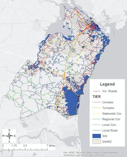
Figure 2. The road network in coastal N.H. by functional classification. Roads within the GWRZ with groundwater less than 5 ft below the road surface (highlighted in red) are the most vulnerable.
Vulnerable roads
Mapping roads within the groundwater-rise zone shows which roads will experience sea-level-rise-induced groundwater rise. However, not all of these roads will experience reduced pavement life. Only those roads where groundwater is already close to the supporting layers underlying the asphalt concrete will be impacted.
In New England, typical pavement-structure thicknesses are rarely more than 5 ft from the top of the road to the top of the subgrade. Roads where groundwater is currently deeper than 10 ft will likely not be impacted. Roads with existing groundwater levels within 5 ft of the road surface are potentially vulnerable to service-life reduction from sea-level-rise-induced groundwater rise. Approximately 30% of the roads within the groundwater-rise zone had groundwater levels within 5 ft (Figure 2) and local roads will be impacted the most (Figure 3).
Pavement structure informs vulnerability
Pavement-engineering analyses were conducted to determine rising groundwater impacts by roadway functional class. In New Hampshire, the functional classifications are interstate (divided) highways, statewide and regional corridors, and local roads. Five roads with different functional classifications and a depth-to-groundwater less than 10 ft below the pavement surface were analyzed. Preliminary findings showed that rising groundwater will overtop some of these roads by mid-century unless adaptation strategies are implemented.
A baseline groundwater depth and the four future groundwater depths within the pavement profile were calculated. Multi-layer elastic analysis using a standard 9,000-lb wheel load identified changes in the pavement response to loading with the rising groundwater. Saturated pavement layers (below the groundwater level) were assumed to have half the stiffness of unsaturated layers. The pavement service-life reduction was defined as the ratio of the number of cycles to failure (Nf) at the predicted groundwater level to the Nf at the current groundwater level, and was evaluated in terms of both rutting and cracking.
Pavement service-life reduction
Pavements will have the greatest service-life reduction when the rising groundwater moves from the top of the subgrade into the base layers of the pavement. Pavement-life decreases by 5% to 20% from cracking as groundwater rises in the subgrade. When the groundwater moves into the base layer, pavement life decreases by 35% or more due to cracking and 40% to 90% due to rutting. Although the pavement structures evaluated will fail from fatigue-cracking before failing from rutting, the rutting response to groundwater rise is important because increasingly warm summer temperatures are already weakening the asphalt concrete.
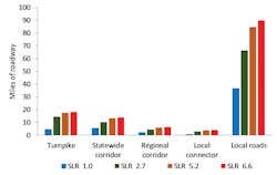
Figure 3. Miles of vulnerable roadway in coastal N.H. within the GWRZ having groundwater rise greater than 0.5 ft by functional classification and sea-level rise scenario.
Pavement structure
Pavement structure can mitigate impacts from rising groundwater depending on layer thickness and material stiffness. The Spaulding Turnpike (divided highway) and Gosling (local road) sites are only 0.5 miles apart. The turnpike will have limited impacts from rising groundwater, while the local road will have significant damage by mid-century. Spaulding Turnpike, a 33.2-mile divided highway, was analyzed at a location approximately 0.9 miles from a tidal river. It has a substantial pavement structure consisting of a thick asphalt concrete layer underlain by base and sub-base layers all on top of two thick layers of fill. The road surface is approximately 7 ft above the natural soils and 5.6 ft above the current groundwater level. Service-life reduction from fatigue cracking at this evaluation site is not predicted until the end of the century, when the groundwater moves into the sub-base. Gosling Road is an important local road, running perpendicular to Spaulding Turnpike, that provides access to Pease International Airport. Its evaluation site is located 0.8 miles from the tidal river. In contrast to Spaulding Turnpike, the road surface at the Gosling Road evaluation site is 3 ft above the natural soils and only 2.3 ft above the current groundwater level, making it highly vulnerable to damage as groundwater rises. A 20% to 50% service-life reduction from fatigue-cracking is anticipated by mid-century, and the road surface will be flooded by the end of the century.
Evacuation route vulnerability
Rising groundwater can potentially compromise coastal roads’ ability to perform as evacuation routes. Pavement analyses revealed differences in the vulnerability between Rte. 101, a state corridor, and Rte. 286, a regional corridor. An initial look suggested that the roads were quite similar. Both roads run perpendicular to the coast across wetlands; both are evacuation routes from coastal properties; and both have similar pavement structures. The evaluation sites were 1-2 miles from the ocean and within 400 ft of coastal wetlands. Currently, Rte. 286’s groundwater is approximately 2 ft below the pavement surface versus 5 ft at Rte. 101. Route 101 will be minimally impacted until 2090, when the groundwater moves into the pavement base layer. In contrast, fatigue-cracking at the Rte. 286 site will significantly impact performance in the next 15 years. In addition to a deeper initial groundwater at Rte. 101, proximity to a nearby river and public water supply wells keep groundwater levels lower.
Moving forward
Not all roads will be equally affected from groundwater rise that is sea-level-rise induced. Even roads in close proximity can have very different impacts. The most vulnerable roads already have a relatively high groundwater table, a pavement structure not well suited to handle wet conditions, and are in an area with rising groundwater.
Once identified, many vulnerable roads can be made resilient within traditional pavement maintenance cycles. While adaptation strategies are still emerging, modifications to pavement structures such as increasing layer thicknesses and using stiffer materials are being evaluated using multi-layer elastic analysis coupled with projected groundwater rise. Adaptation will avoid the costs of more frequent maintenance and repair and determine the most cost-effective adaptation actions.
Identifying vulnerable coastal road infrastructure can be challenging because rising groundwater depends on the region’s geology. Leveraging data and expertise from multiple agencies can reap significant benefits when developing the necessary guidance for targeted adaptation planning. As communities move forward to take action and make investment to address rising tides, it is essential that groundwater impacts be part of a communities’ strategy to determining the most efficient investment of their resources.