North Dakota is ready for exposure
North Dakota has more miles of road per capita than any state in the nation. To manage all the data associated with such a large road network, officials at the North Dakota Department of Transportation (NDDOT) determined that a geographic information system (GIS) web portal that integrates multiple datasets in an easy-to-use interface would be a cost-effective solution for increasing data sharing and usage.
NDDOT’s GIS web portal was designed to access transportation-related data and information quickly and easily. The system integrates with other spatially enabled applications, such as Image Log, NDDOT’s digital library of road views. Image Log became the first application for this integration model and completed the foundation for the new GIS web portal.
As part of the overall project, NDDOT also implemented the Online Roadway Analysis and Mapping Portal (OnRAMP). Developed with the aid of Pennsylvania-based GeoDecisions, OnRAMP was designed to ensure that its foundational technology would meet the future needs of a functionally rich portal. In the development of OnRAMP, innovative technical approaches were required to present the large volumes of information on a web-application platform. OnRAMP was created using primary development languages stored in Esri’s ArcGIS Server. The application uses Microsoft’s Silverlight web browser plug-in, giving the user a polished look and feel along with making it extremely user-friendly.
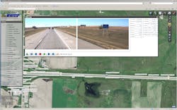
To fully expose the portal’s integration capabilities, OnRAMP was built with several access points to Image Log data. Known as Video Log, the new Image Log viewer can be accessed within a results window generated by a query or map selection. The user can directly click a point on a road rather than typing in information. Previously, users accessed Image Log data through a desktop application for asset location/validation, virtual inspections and viewing of curves and line-of-sight issues. Image Log access required a high-speed connection to the network, which prevented many from utilizing the information. With the new web-based environment of OnRAMP, access to images through the lower bandwidth connections in district offices became possible.
To address the issue of georeferencing images in OnRAMP, a tool was developed that provides the option of using GPS data or an interpolation routine, based on route name, mileposts and image sequence, to locate each roadway image. This tool allows an administrator to dynamically update images with accurate location and reference data, while a vehicle icon denoting the current Video Log location can be tracked on the map as a user drives virtually down the road.
The integrated web-based map interface, the ability to view and save full-resolution images and the capability to export a video file let users see the image data more effectively. Additionally, OnRAMP improves enterprise transportation information sharing and integration throughout NDDOT. The system enhances accessibility of the existing Image Log data via the web to all NDDOT users. It also meets the challenge of disseminating attribute and image data over varying Internet bandwidths at district offices and provides a user-friendly web portal interface.