The direct route
Located just north of Indianapolis in Hamilton County, Ind., Carmel is a dynamic edge city with award-winning schools, thriving businesses and family-oriented neighborhoods.
Once thought of as a “bedroom community” to Indianapolis, today more people commute into Carmel to work during the day than sleep there at night. The population has nearly tripled from 32,487 in 1996 to almost 100,000 in 2017. Thanks to annexations, the city’s area also has more than tripled in square miles from 12.59 in 1990 to 48.55 today.
In 1996, newly elected Mayor Jim Brainard accurately forecasted this growth and decided to implement an aggressive plan to build a sustainable, walkable, bike-friendly city that would be like none other in central Indiana. Mayor Brainard also adopted a strategy to invest in the arts, creating an Arts & Design District to help resurrect a dying downtown and a new Center for the Performing Arts, including a 1,600-seat concert hall known as the Palladium. By creating these new districts, the mayor and the City Council elevated the quality of life in Carmel as part of a plan to attract new businesses, corporate headquarters and a high-quality workforce. The plan has worked. Today, Carmel is home to more than 125 international, national or regional corporate headquarters. As Carmel grew rapidly, so too did the amount of traffic on local roads that had been built for an agricultural community by the city’s forefathers. That, Mayor James Brainard recognized, had to change.
When it began
Since taking the helm of the city in 1996, Brainard has overseen the elimination of dozens of traffic signals and the installation of 115 roundabouts, more than any other city in the U.S. The first roundabout in Carmel was constructed at the intersection of 131st Street and River Road on the city’s northeast corner in 1997. In 1998 the adjacent roadway corridor, Hazel Dell Parkway, became the first corridor to open with multiple roundabouts. In 2008, the city took on what was, at that time, its most ambitious and challenging road construction project that incorporated roundabout interchanges.
Keystone Parkway, a major north/south thoroughfare carrying 50,000-60,000 vehicles per day (VPD), was a constant source of traffic congestion, had more than 200 vehicle accidents per year, and depended on signalized intersections that could no longer handle its traffic volumes. Formerly a state-controlled highway (S.R. 431), the plan to fix this problem was originally to add travel lanes, a plan put forth by the Indiana Department of Transportation (INDOT).
Brainard had a better idea. After working through a roadway relinquishment with INDOT, the city took control of the road, nixed the idea of adding new lanes and decided to eliminate all of the signalized intersections. The city lowered Keystone Parkway at major intersections to create grade separation that allowed the construction of teardrop-shaped roundabouts at the six intersections along the 5-mile stretch. Construction is scheduled to start on the final interchange at 96th Street and Keystone Parkway this summer.
The Keystone Parkway reconstruction project has been critical to further proving the effectiveness that roundabouts can have with the proper planning and design. Shortly after construction of the parkway was complete, INDOT retooled a grade-separation project on the U.S. 31 corridor in the west-central portion of the city for a roundabout.
At the beginning of 2016, city officials began working on a bold new infrastructure plan to add more roundabouts, provide storm-water improvements, construct multi-use paths and complete several roadway reconstructions. Nearly $250 million was committed to infrastructure improvements, targeting the central core and east side of the city. Past improvement projects had focused on the west side but this new plan introduced funding for more than 30 new roundabouts. An additional infrastructure package passed in 2017 included almost $95 million in new projects; included were an additional half-dozen new roundabouts.
In the midst of this ambitious plan of investment, the city celebrated the opening of its 100th roundabout on Nov. 17, 2016: “This marks a milestone in a 20-year initiative to transform a transportation network that had previously been littered with failing, traditional suburban traffic lights, four-way stops, and other poorly functioning, dangerous intersections,” stated a press release. “The network-wide incorporation of modern roundabouts has transformed Carmel’s roadways into a smooth-flowing network that has dramatically reduced accidents.”
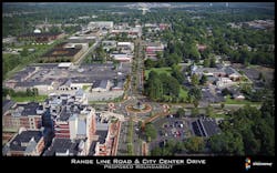
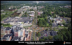
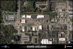
The current roadway configuration of the 1.5-mile Range Line Road project will transition from a five-lane roadway to just three lanes through an area that is mostly commercial.
Staying safe
Carmel currently has more roundabouts than any other city in the country and is, therefore, perhaps the best place to study the impact of roundabouts on personal safety. The results have been promising and should be taken into consideration whenever a city or town debates the merits of building roundabouts. City data has shown there is a 68% reduction in personal injury incidents and a 90% reduction in accidents with fatalities. It also can be noted that if accidents do occur, there is a reduction in overall cost associated with the accident. The implementation of public art, intense landscaping and hardscaping around and in the center of the roundabouts is visually beneficial but also serves as a calming mechanism to drivers who need only look to the left as they yield before safely entering the roundabout. In addition, with these come increased pedestrian and bicycle connectivity due to designated crosswalks, which not only afford safe pedestrian crossing but also an improved pedestrian experience.
The future of Range Line Road
Growth in Carmel was once primarily seen through managed suburban sprawl and annexations of surrounding unincorporated areas. Today, the city recognizes the future of growth is coming from the city’s continued investment in its urban core.
The Midtown area recently saw the opening of the aforementioned Allied Solutions, a nearly 50,000 sq ft office building providing a home for up to 600 jobs within the central core. Within the next two years the area will see the opening of two more office buildings resulting in 150,000 sq ft of office space and nearly 500 apartment units, along with the opening of multiple restaurants and a distillery. A separate $25 million reconstruction of the Monon Greenway also is underway, further increasing the value of land in and around this area. Carmel is seeing redevelopment of the older 1970s developments along Range Line Road where $150,000 homes are either being purchased and remodeled, or replaced with new homes that sell for up to $700,000.
All of this growth in the central part of Carmel has prompted the city to take a fresh look at one of its oldest roads, launching the Range Line Road Streetscape project. The current roadway configuration of the 1.5-mile Range Line Road project will transition from a five-lane roadway to just three lanes through an area that is mostly commercial. Before the project, seven traffic signals controlled the intersections. Traffic volumes ranged from 20,000 VPD at the south end of the project to 15,000 VPD at the north end. The project started out with the goal to reduce the overall lane dimensions to a single lane in each direction with on-street parking and added pedestrian features.
After further traffic analyses were completed, it was decided that the southern portion of the project would remain two lanes in each direction with a landscaped median. An 8-ft-wide multi-use path on each side of the roadway to promote a pedestrian- and bicycle-friendly atmosphere also will be added. The northern portion of the project will be reduced to a single lane in each direction with a landscaped median. Also included in this area is a protected, multi-directional bike lane along the east travel lanes. This bike lane is separated with moveable, on-street planters that can be relocated during special events such as the CarmelFest parade on the Fourth of July. Construction on the northern section was set for Spring 2018 completion, while the southern section will begin construction in Fall 2018.
The main project goal was to improve the safety and efficiency of all transportation types along Range Line Road. Key features to help achieve these goals included adding a landscaped median along the entire corridor, replacing signalized intersections with roundabouts and utilizing raised pedestrian crosswalks at each roundabout.
“Typically when a city talks about improving traffic flow, it involves building new roads or adding lanes. But in this case, we plan to do the opposite,” said Brainard. “This large, multi-lane, uninviting expanse of road will be replaced by an inviting, aesthetically pleasing, protected boulevard. What is currently a ‘pass-through’ corridor will soon be transformed into a tree-lined, sculpture-infused pedestrian destination.”
Finding a balance
The project’s close proximity to the main fire headquarters has created some concern that a narrowed roadway with reduced lane capacity will create issues from a public safety standpoint. In addition, there was concern that the raised pedestrian crosswalks could create difficulty getting fire trucks through the roundabouts. All of these concerns have been addressed through intelligent design. The single-lane roadway section features a mountable roll curb that also has a mountable median paver in the event that a fire truck needs to quickly move along Range Line Road. The main objective to the raised pedestrian crosswalk is to slow vehicles down as they traverse through the roundabout. Speeds are typically around 15 mph versus 20 mph along other roundabouts. This promotes a safer pedestrian/vehicular interface, which in turn promotes public safety.
The city of Carmel launched the Range Line Road Streetscape project due to vast growth in the central part of the city.
Biking in Carmel
Finally, it is important to point out that the city does more than build roundabouts and improve mobility on four wheels. There also has been a great deal of investment for those who prefer two wheels.
For years Carmel has worked to develop safe and convenient bicycle infrastructure that people of all abilities will feel comfortable using. The city currently has nearly 200 miles of paths and greenways and is continuing to build out its network at a rate of 15 miles of path each year. Carmel also promotes cycling for transportation and/or recreation by using its 100-mile Carmel Access Bikeways route network. The city has required new developments to include bicycle parking for over a decade and now has thousands of bike parking spaces throughout the community. Thanks to connected trails and paths, it is possible for many to commute from their homes to work by bicycle. Even if they work in downtown Indianapolis, bike commuters are able to hop on the Monon Trail and take it south to Indianapolis.
The Monon Greenway was once a controversial project, as the abandoned railroad bed was transformed into the trail in Indianapolis and Carmel (and now in Westfield to the north). In addition to fears of the unknown impact related to crime and loss of privacy, there were many who lived along the trail who believed their property values would suffer. That has not been the case.
There have been multiple studies on how the Monon Greenway affects the property values of its neighboring communities since it was constructed through Carmel—the most recent analyzed single-family and condominium sales in neighborhoods adjacent to the Monon in Carmel and Westfield, Ind., from 2012 to 2014. The study concluded that there is a premium of 13% for single-family dwellings and a premium of 4% for condominiums situated on the trail vs. a similar property off-trail. The study also indicated that not only is there a premium for lots adjacent to the Monon, but those lots will typically be the first to sell in developments. Previous studies have called this area central Indiana’s equivalent to beachfront property.
All of these investments have been designed to create a sustainable, walkable, bike-friendly and environmentally friendly city where today’s new generation of workers desire to live. Carmel residents enjoy steadily improving property values, and a quality of life that continues to draw private investment and new opportunities.