Nooks & crannies
Research and development efforts are actively taking place to make small unmanned aerial systems (sUAS) necessary tools for transportation infrastructure inspections.
As these efforts continue to advance the transformation process from idea into reality, it is necessary to rely on fundamental systems engineering concepts to increase the chances of mission success.
The right tools
Bridges are very important to the economy of any nation. These transportation infrastructure elements keep businesses in operation by allowing continuous movement of people and goods. There are more than 600,000 bridges in the U.S. Their average age exceeds 40 years, and according to 2015 data compiled by the Federal Highway Administration, 23% of them are classified as functionally obsolete or structurally deficient. These statistics have motivated professionals from the transportation industry and academia to investigate ways to improve the maintenance and inspection processes of these key infrastructure elements.
Recent technological advances have led to the possibility of using sUAS for transportation infrastructure inspections. These systems are envisioned to facilitate the gathering of high-definition visual data from hard-to-reach components such as gusset plates on top chords of railroad bridges, or between girders in underside highway bridges. Furthermore, sUAS can be equipped with various sensors (e.g., LiDAR, thermal, hyper-spectral) to obtain specific types of data for analyses. Potential benefits from incorporating sUAS into inspection processes include significant reductions in both cost and safety risks associated with inspectors and motorists, as well as improvements to the effectiveness and accuracy of structural health evaluations.
A systems engineering approach
The systems engineering discipline involves technical and managerial approaches to develop operable complex systems that meet requirements within various types of constraints. Proof-of-concept studies are used within the systems-engineering discipline to gain insights into the capabilities of a system, and evaluate the feasibility of developing and implementing the system in the real world. Proof-of-concept studies can facilitate the identification of functional requirements to clearly specify what the system must perform to accomplish particular missions.
Researchers at Florida Tech have spearheaded funded research efforts to conduct proof-of-concept studies on the use of sUAS for bridge inspections. One of these studies, funded by the Florida Department of Transportation (FDOT), dealt with investigating the capabilities of using sUAS with an integrated imaging sensor for bridge inspection purposes. On another project, funded by the National Academies of Sciences (NAS) Transportation Research Board (TRB) Safety IDEA Program, the team has been conducting a proof-of-concept study to evaluate the use of LiDAR and imaging sensors integrated into sUAS for railroad bridge inspections. What follows is an overview of these respective research studies.
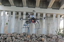
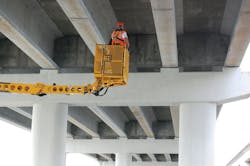
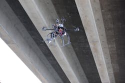
Figure 1. (left) An inspection team in bucket truck; (right) an sUAV hovering between girders.
Study 1: sUAS for on-site visual inspections
The most common approach to bridge inspections is visual examination by trained and experienced inspectors. Although often complemented with other non-destructive testing approaches, visual inspections have long been used as the primary technique to assess the structural health of bridges. State agencies rely on visual inspections to make key decisions about the health of structures—such as allocation of human resources and funds to maintain/repair structures—that significantly affect public safety and costs.
Following a systems engineering approach, this initial proof-of-concept study was conducted to identify system limitations and gain insights into the expected usefulness of sUAS as tools during the inspection process of bridges. Extensive indoor controlled experiments using industrial fans were conducted to evaluate sUAS flight response in controlled wind conditions, to measure image quality in different flight scenarios, and to determine image quality in low-light conditions. Results from these experiments provided evidence that support the potential ability to fly sUAS in high-pressure zones, maintain safe flying proximity of 2-3 ft from a target, and the ability to detect concrete crack sizes down to 0.02 in. These findings, coupled with the ability to maintain adequate resolution under relatively low-light conditions, highlighted the high potential to use sUAS systems to assist bridge inspectors during field inspections.
Altitude, payload and maneuverability tests also were conducted to understand sUAS performance and limitation parameters related to their use for transportation infrastructure inspections. Altitude testing results showed that first-person-view systems provide a pilot the capability to easily detect sUAS orientation up to at least 400 ft vertically and 1,500 ft horizontally. These tests also showed that the maximum vertical distance to reliably detect sUAS orientation is significantly limited if relying only on the sUAS’ LED lights. Payload testing results showed that carbon fiber propellers can increase flight time by 10%. These tests also resulted in a table that shows maximum flight times as a function of battery type, battery configuration and payload weight. Maneuverability testing results showed that the sUAS could be properly operated by a skilled operator at a minimum clearance of 3 ft from a target and with constant wind speeds of 15 mph.
Limited field tests were conducted to collect image data of underside bridge sections. Figure 1 (left) shows inspectors being lifted by a bucket truck to see between girders of a highway concrete bridge. Figure 1 (right) shows a sUAS collecting and streaming video data within the same concrete girders during a field test. On the ground, FDOT inspectors guided the pilot to focus on specific areas of interest based on the video streamed to a ground station in near real-time. Visual assessments of the collected data (i.e., image and videos) by the research team and FDOT inspectors showed the potential benefits from using sUAV systems for structural inspection purposes. Images collected during field tests were of similar or better quality than those collected by FDOT inspectors during previous inspections. Some of the defects identified using the sUAS approach were rust, cracks through epoxy patches and bearing deformations. These results highlighted some of the capabilities of using sUAS for bridge inspections.
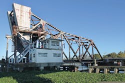
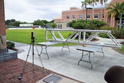
Figure 2. (left) A real-life railroad bridge; (right) a PVC bridge structure for controlled experiments.
Study 2: LiDAR for bridge inspections
One of the objectives of this ongoing proof-of-concept study is to investigate the applicability of using sUAS with an integrated mobile Light Detection and Ranging (LiDAR) sensor to help detect displacement of bridge components. The general approach involves the following steps:
- Design and develop an aerial platform capable of carrying a Velodyne HDL-32E mobile LiDAR sensor;
- Evaluate existing or newly developed registration algorithms on their ability to align 3-D point-cloud LiDAR data; and
- Conduct controlled experiments to collect LiDAR data, develop 3-D models and evaluate the usefulness of the 3-D models to help detect displacement of bridge components.
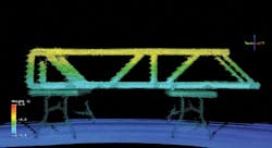
As a preliminary experimental approach, a small-scale bridge was designed to conduct controlled experiments. This mockup bridge was modeled after a real railroad bridge, and was constructed using polyvinyl chloride (PVC) material (Figure 2). Various experiments were conducted to develop 3-D models of the PVC bridge from LiDAR data, and evaluate the usability of the models for detecting bridge deviations/inclinations from the horizontal axis at different distances from the bridge (Figure 3). The resulting 3-D models showed that a 0.5-in. inclination was easily identified with the sensor located 10 ft from the structure, using only 20 LiDAR scans. A field test also was successfully conducted to evaluate the applicability of 3-D models from LiDAR data to help detect horizontal displacements of bridge components. It can be safely assumed that more scans at different sensor locations will result in denser 3-D models, which will improve the usability of the 3-D models for detecting vertical and horizontal displacement of bridge components.
Figure 3. A mobile LiDAR 3-D model showing 0.5-in. structural deviation.
Future research opportunities
Overall, the results obtained from these proof-of-concept research efforts provide evidence that significant benefits can be obtained from the use of sUAS as tools during bridge inspections. It can be safely stated that sUAS are mission-specific. For example, a sUAS engineered for high mast luminaire (HML) inspections will not necessarily perform well during underside bridge inspections. HML inspections will require a sUAS to fly in open spaces, with good flight stability due to almost-guaranteed GPS signal locks, and will probably only require a single imaging sensor. On the other hand, underside bridge inspections will require operating sUAS in tight spaces, with limited GPS signals, with top and bottom imaging sensors (and potentially additional sensor types), and in the case of bridges over water, added equipment to prevent electrical system damage if the aerial system falls in the water.
Proof-of-concept studies can help to identify functional system requirements, which are based on the type of mission that the sUAS is intended for. Afterwards, efforts to identify non-functional requirements (i.e., quality attributes) must take place. Defining quality attributes depends heavily on the type of mission (e.g., operating the sUAS in open vs. confined spaces). Examples of quality attributes include operability, reliability, maintainability, robustness, safety and transportability.
There still exist gaps that need to be addressed in order to use these aerial systems safely and effectively in practice. Conducting further research efforts that closely involve a systems engineering mentality can lead to the effective integration of these complex aerial systems into transportation infrastructure inspection processes.
