Measured steps
As the far-flung but still young intelligent transportation systems industry further consolidates its substantial research gains, planners are focusing increasing attention on the safety promise offered by using radio waves to connect vehicles with each other and with roadside equipment.
Now dubbed the Connected Vehicle program, this effort is expected to receive its first substantial thrust toward actuality when the U.S. DOT’s National Highway Traffic Safety Administration makes decisions this year and in 2014 on whether to start rulemaking that would turn the DOT-directed research toward actual deployment of cars, buses and trucks—and later trains—all equipped with the ability to warn drivers of impending crashes.
DOT officials figure that fully 80% of highway fatalities involving drivers who are not impaired by alcohol or drugs may eventually be prevented by this hazard warning system.
“This research should bring us a step closer to what could be the next major safety breakthrough,” said Ray LaHood, secretary of transportation.
“Vehicle-to-vehicle technologies have the potential to significantly reduce fatalities and injuries in crashes and could one day help motorists avoid crashes altogether,” said David Strickland, NHTSA administrator. “Those technologies may prove to be the next game changer as we look at the future of auto safety.”
The Connected Vehicle program—comprising both vehicle-to-vehicle (V2V) and vehicle-to-infrastructure (V2I) communication—is not the only ITS focus these days. Agencies and companies in the ITS field are seeking to move ahead on a number of fronts, including traffic-condition advisories, advanced traffic management, red-light and speed camera enforcement, toll roads and high-occupancy toll (HOT) lanes, telematics, integration of traffic data between highway vehicles and rail or bus transit, other transit ITS needs and better synchronized traffic lights, to name some of the most active ones. Progress on some fronts is notable, but it is slow on others.
Working for tips
Preventing more progress is a lack of adequate funding, when compared with the need, ITS advocates say, and at a time that budget considerations are becoming ever more pressing.
“Local agencies are really hurting financially these days. They barely have enough money to fight fires,” said Philip Tarnoff, a transportation consultant and former director of the Center for Advanced Transportation Technology at the University of Maryland.
The continuing political turmoil in Washington, D.C., profoundly complicates the picture. ITS and other transportation planners have been faced for some time with a funding plateau and uncertainty about the future, as Congress kept extending the previous SAFETEA-LU surface transportation law. Now that a new two-year law spells out funding through 2014, that uncertainty has been removed.
But the new act, Moving Ahead for Progress in the 21st Century—known fondly as MAP-21—holds money authorizations at the previous level, except for inflation. When it comes to deployment financing, there is no longer any explicit federal pot, and the days of earmarked funds for individual projects are gone. ITS planners have to compete with other state transportation spending for deployment money. And they have to compete with other transportation research programs for research money. Under MAP-21, the U.S. DOT’s Research and Innovative Technology Administration (RITA) research budget was trimmed to $100 million a year from $110 million in the previous year.
ITS’ money outlook remains troubled.
“With the election behind us, Congress must address the ‘fiscal cliff.’ If not addressed, the entire economy will be impacted,” said Scott Belcher, ITS America president and CEO, shortly after Barack Obama’s re-election. “Initially, transportation will be somewhat protected because the majority of federal funds are collected from the Highway Trust Fund. This will not be sustainable over the long term. States will see their overall funding decline unless they identify new funding sources (e.g., tolling, new taxes, bonds, mileage-based user fees). In an era of declining federal resources, ITS will get squeezed by those states that don’t think they can afford technology. On the other hand some states will invest in technology as an alternative to traditional funding.”
The volatile financing outlook is present even as ITS is reaching a “tipping point” in development of the Connected Vehicle and other programs, Belcher added.
One ITS area where there’s a need for further input and refinement is in measuring the performance of transportation systems. Officials of the Institute of Transportation Engineers (ITE) say that a significant challenge confronting the profession is measuring success in the application of ITS technology. Many transportation agencies aren’t yet in a position to devote either the time or funds necessary for effectively integrating ITS with their traffic management and operations process, even though ITS may offer a greater cost/benefit for achieving their management and operations goals. This is particularly evident in the transit industry, said Philip Caruso, ITE deputy director.
Many agencies lack a clear idea of what to do with all that technology research and are unsure of what kinds of benefits it offers. What is especially lacking is any measure of the performance of ITS systems, which is necessary for judging their value. “We’re not at that point yet,” said Caruso.
Meanwhile, the technology continues to advance. Here are highlights of some other major ITS areas:
Transit
ITS is becoming increasingly important to rail and bus transit. Buses (rapid transit and otherwise) and rail transit rely heavily on ITS because they all operate in mixed traffic, said Lou Sanders, director of technical services for the American Public Transit Association.
“Transit systems represent a major base of deployed ITS technology, including automatic vehicle location, automated passenger counting, computer-aided dispatch, condition monitoring, traffic-signal priority, CCTV, wi-fi and traveler information systems,” he added. “All transit modes are looking at new approaches to fare collection, smart cards, credit cards, regional systems, cell-phone and other near-field applications.”
One of the broadest combinations of cars, trucks and transit under development is the integrated corridor management (ICM). Fully 37 years ago, Bill Coleman, President Gerald Ford’s transportation secretary, defined “multimodal transportation” this way: “When you get off the train, there’s a bus waiting for you.”
Coleman was onto something. There has long been a need to integrate the various modes of transportation, but the nation has a long way to go to really accomplish that. Now, treating highway and transit modes as a system, achieving strong efficiencies, facilitating better choices by travelers and otherwise viewing surface transportation as coherent is getting vigorous emphasis.
Steve Mortensen, senior ITS engineer in the Federal Transit Adminstration Office of Research, Demonstration & Innovation, emphasized a unified approach to such functions as “the integrated management of freeway, arterial, transit and parking systems within a corridor.” The DOT has conducted a competition for a model ICM project, narrowing the field to two winners: San Diego’s I-15 and Dallas’ I-75 corridors, with this third-stage federal funding of $8.7 million and $5.3 million, respectively.
“ICM is a concept that has been around ITS from the beginning [about 25 years ago],” but suffered from a lack of good travel data, said Piotrowitz, at the RCOC in Michigan. But, he said, “there is a good chance to make that happen now.”
Beyond that, the FTA is working with FHWA and RITA to include buses in the Connected Vehicle program, and the transit bundle of applications—integrated Dynamic Transit Operations—has finished studies in preparation for a demonstration project. The FTA said that transit operations will become more “environmentally friendly,” reducing fuel usage and engine emissions, and that travelers will turn more to using mass transit.
The DOT ITS strategic plan envisions a multimodal intelligent traffic-signal system, getting traffic data through CV means for transit and other vehicles. The system would replace limited-ability sensing systems with modern methods that monitor signals, change signal-control plans by time of day or in response to traffic or provide adaptive signal timing that reacts to traditional vehicle detector data.
The signals would benefit from the CV use of Dedicated Short-Range Communication (radio), along with other wireless communication data using Wi-Fi, 30/40 and Bluetooth-enabled smart phones. The plan also envisions providing transit buses with signals showing pedestrians or the bus nearing a curb, as well as aiding rail- and bus-transit vehicles at grade crossings and traffic intersections.
Finally, rail-transit operators are working on use of communications-based and positive train control (PTC), on mandate from Congress and the FTA. CBTC is a railway signaling system using telecommunications between the train and track to give the exact position of a train more accurately, for a more efficient and safer way to manage railway traffic. PTC involves requirements for monitoring and train movements for safety—train separation, crash avoidance and speed enforcement, with the train getting information as to its location and where it can safely travel.
Congress has set a 2015 deadline for commuter rail operations to adopt positive train control, and FTA is working with the rail-transit industry on this project. In response to a National Transportation Safety Board recommendation, FTA told rail-transit agencies to see if their systems have adequate safety redundancy when losses in train detection occur. FTA also awarded research funds to develop and test train control technologies and has supported Metrolink’s effort in southern California to install PTC train control on its 500-mile commuter rail network by December of this year.
Traffic advisories
Aided by private firms including Tom Tom, Inrix, Navteq and Air Sage, state DOTs are giving increasingly precise, sophisticated information about traffic congestion, other vehicles’ locations, speeds and other data.
“There is little doubt that when it arrives, the backbone of the [21st] century highway system will be a powerful combination of data communications and information dissemination to travelers prior to their departure, while en route and after reaching their destination,” wrote transportation consultant Tarnoff in his new book, “The Road Ahead.”
The I-95 Coalition, a group of 16 state DOTs along I-95, covering 39,900 freeway and arterial miles continuously from Maine to Florida, continues to expand use of Inrix-provided data, said Ted Trepanier, Inrix executive director-public sector. And Inrix has been selected by the San Francisco Bay Area Metropolitan Transportation Commission to provide live traffic data to travelers through its 5-1-1 system, including phone, website, roadside message signs and mobile phone.
The commission serves 33 transit agencies in nine counties, 7 million residents, 3 million commuters making 20 milion daily vehicle trips, on 1,400 miles of highways and eight toll bridges, said Melanie Crotty, director of operations. Real-time traffic and transit data are delivered by phone, website, mobile phone, app, texting and transit hub and highway CMSs.
More than 25 state DOTs as well as the U.K. Highways Agency are using Inrix traffic information and analytics tools today to fill the gaps in their sensor networks, conduct planning and performance measurement analysis as well as extending the insight to consumers through traveler-information services on their websites, via 5-1-1 services or in mobile applications.
Inrix’s traffic intelligence platform analyzes billions of data points from hundreds of public and private sources including a crowd-sourced network of nearly 100 million vehicles and devices. Through their combined network of commercial fleet and consumer vehicles, Inrix analyzes data showing their location, speed and heading to determine congestion, corridor travel times and other data, which is updated every minute to the end customer. The company also provides an analytic suite of data to be archived, so the customer can estimate coming traffic flow, and compare current with year-ago data.
Though the 5-1-1 network covers much of the nation, its growth has stalled in recent years and has expanded beyond telephone service to include DOT websites and variable message signs (which themselves now offer travel times just about universally).
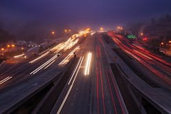
Traffic management
State DOTs are using various means to manage traffic, but the most sophisticated is an approach called “active traffic management” (ATM), so far used only by Washington state (three highways into downtown Seattle) and Minnesota (one stretch of I-35).
In Washington, overhead signs monitor each lane, opening and closing them depending on traffic flows and dictating speeds, on I-5 from the south and across two floating bridges from the East—I-90 and SR 320. The agency plans to open a fourth ATM location—turning shoulders into “hard shoulders” on I-5 from Everett on the north, when more lane capacity is required.
The move is needed, said Bill Legg, state ITS operations engineer, “short of adding an extra lane, which costs a lot of money, which we don’t have right now.” His agency also plans to create a managed lane on I-90, serving a huge new area for motorists to put chains on their tires prior to going through snowy Snoqualmie Pass, instead of stopping on the shoulder or even on the road, as they do now.
The Michigan DOT has launched its own somewhat advanced traffic-management effort, using software provided by Delcan Technologies, covering Detroit first and then expanding throughout the state. It allows the agency to manage traffic from anywhere in the state by sending messages from computers to overhead or roadside signs, telling of trouble spots and travel times, said Matt Smith, ITS program manager.
The messages mainly display road conditions throughout the state, showing crashes, construction and other trouble spots, so that motorists can adjust their travel plans and not contribute to the congestion. MDOT also shares the traffic information in its travel advisories, with partner transportation agencies in the state and the motoring public.
Maricopa County, Ariz., is evaluating another kind of control, badly needed throughout much of the nation—improved synchronization of traffic lights, said Faisal Saleem, ITS branch manager. The aim, he said, is to make intersections safer, including deciding when police, fire and other emergency vehicles can pass through, and when it is safe for pedestrians to cross the street.