**This article was addended by the author, with a update on recent progress; the addendum follows the original article below.**
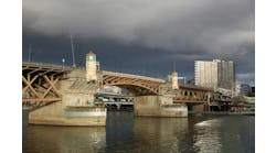
North San Francisco Bay commuters have long complained about the traffic congestion along S.R. 37, hoping that the California Department of Transportation (Caltrans) would widen the highway and improve intersections.
Until recently, however, no one realized that a slow-moving tidal wave threatened this important link with inundation and closure.
The Road Ecology Center (REC) at the University of California-Davis, with support from AECOM, and funding from the Transportation Research Board SHRP2 program and Caltrans, determined that certain stretches of S.R. 37 were at risk of failing due to sea-level rise. One stretch that averages 40,000 vehicles per day was at short-term risk of catastrophic flooding if one vulnerable levee failed, and it was estimated that several stretches would be threatened by 2050 with overtopping. This led to a proposed set of adaptive scenarios to protect the route from sea-level rise, ranging in cost from $1.3 to $4.3 billion.
Planning ahead
Sea-level rise of 8 in. along the U.S. coastline is predicted to increase by another 12-24 in. by mid-century, though the actual degree of inundation is unknown, and no corresponding adaptive management process has been proposed. Many billions worth of coastal property, transportation infrastructure, developed areas, and economic activities are jeopardized in the near term (0-30 years) by both the gradual inundation effect of sea-level rise and the stochastic addition of sea elevation during storm events and global cycles (e.g., El Niño).
Infrastructure is already flooding more often than in recent history. For example, the Tybee Island causeway in Georgia began experiencing “nuisance flooding,” including complete overtopping, at U.S. 80 and U.S. 17 in 2014 and 2015 during very high tides. Regional news outlets have quoted these events as the “new normal” due to climate change-induced sea-level rise. In California, king tides have affected local roads and highways with periodic flooding and are increasingly covered by regional news outlets.
This degree of rise and the immediate time frame means that it would be best to immediately start planning for infrastructural modifications in current regional and corridor plans. The proximity of these highways and coastal ecosystems, which are home to endangered species, recreational and economic benefits, and the subject of many regulations and restoration investments, means that accurate and timely information about the actual extent of sea-level rise impacts will be critical during highway adaptation. All coastal planning agencies seeking to adapt coastal-built systems to sea-level rise are using remote-sensing-based elevation models and predictions, which have unknown accuracy and uncertain time frames.
Aerial view of S.R. 37, looking west along the stretch of highway most vulnerable to short-term failure due to sea-level rise. Photo: Stephen Joseph, courtesy of Sonoma Land Trust
The adaptive planning process
To meet these challenges, the REC developed a generalizable planning and assessment process to help state departments of transportation (DOTs) adapt. S.R. 37 was a worthy test ground because it is one of the most vulnerable California highways to temporary flooding and permanent inundation due to sea-level rise. It is adjacent to protected coastal systems (e.g., beaches, tidal wetlands), thus increasing regulatory oversight. Congestion and threats from sea-level rise led to REC, local congestion management agencies and Caltrans engaging stakeholders to collaboratively plan for a new highway adaptive and resilient to associated impacts. We framed adaptation using Eco-Logical, a planning process developed by the Federal Highway Administration (FHWA) to better integrate transportation and environmental planning.
Planning and constructing modifications to a highway corridor usually requires consideration of current and future travel modes, linked arterial roads and highways, and current and proposed motor-vehicle capacity. An important feature of sea-level rise effects on coastal systems is that most of the natural systems affected are protected by one or more statutes and agencies. In addition, these natural systems and the species that call them home will move inland both gradually and stochastically. This means that adaptive action taken to preserve transportation systems also must take into account adjacent and connected natural systems. In U.S. coastal areas, saline, brackish and freshwater marshes abut many low-elevation highways/interstates and other infrastructure.
A critical part of the process was the inclusion of stakeholders from the beginning of the adaptation planning in 2011, with 49 individuals from 40 organizations in the first year growing to 204 people from 102 organizations by 2016. The participation was very diverse, with most involved coming from local government, followed by state government, non-government organizations, private business/landowners and federal government. Most people were not familiar with state transportation planning processes, and there was often frustration with the pace at which Caltrans appeared to move on what many saw as an urgent need. Within Caltrans, there was a wide range of views about the process, from apparent passivity/neutrality to enthusiastic advocacy for improved adaptive planning.
Anticipating threats
Potential inundation was predicted using a LiDAR-based model of elevation and a GIS model that determined whether or not a raster cell representing land would be inundated by new sea elevations (at high tide). LiDAR (Light Detection And Ranging) is a method for measuring distance that has been adapted to measure fine-resolution elevations of landscapes. Predictive models of sea-level rise-related inundation are increasingly popular (every U.S. coastal state uses them for threat assessment), and the public seems to find them engaging and educational.
The GIS model took into account and excluded land areas protected by berms and levees. Vulnerable segments of highway and other parts of the surrounding landscape were prioritized for action based on a combination of their vulnerability and importance. While using this predictive modeling approach, the team also recognized that little is known about how well the maps reflect either conditions with certain sea elevations or at certain time points. Uncertainties in inundation conditions arise from a combination of data accuracy (LiDAR reflection from vegetation can complicate understanding of ground elevation) and the absence of important processes in predictive modeling (e.g., from a changing wave-action front).
This first-cut prioritization of highway segments resulted in two important findings: 1) Certain highway segments were more likely to be vulnerable than others, affecting the operation of these segments as part of the larger regional network; and 2) the potential cost and footprint of structures providing vertical adaptation through approximately 2100.
Predicted flooding depth for marshes (green to blue scale) and highway (red scale) with 24-in. of sea-level rise. Source: http://hwy37.ucdavis.edu/maps
Threats assessment
S.R. 37 between U.S. 101 and S.R. 121 was the most vulnerable portion of the segment; it would be exposed to permanent inundation with sea-level rise of approx. 24 in., primarily due to overtopping of flood protection levees along the Bay shoreline and adjacent rivers and creeks. S.R. 37 between S.R. 121 and Mare Island is generally higher in elevation, but would still be impacted by permanent inundation under the 36-in. scenario along low-lying portions of the highway in the eastern and western ends of the segment. S.R. 37 between Mare Island and S.R. 29 would not be overtopped under a 36-in. scenario, but, however, would be under certain conditional combinations of sea-level rise and storm surges. Most highway segments are vulnerable to combinations of sea-level rise and storm surging under different return intervals, or by a 100-year tide event, even under existing conditions without sea-level rise. This highlights the fact that the existing highway is already vulnerable to flooding during extreme events.
Adaptive responses and structures
The original scope of adaptive responses included: a) Diverting traffic inland and abandoning the right-of-way, primarily due to cost of adaptation; b) building a tunnel under the North San Francisco Bay; c) building a higher and wider embankment along the current alignment; and d) building a causeway or bridge along the current alignment. Regulators balked at the idea of a higher and wider embankment across coastal marshes due to both the footprint of the structure and the effect on current and future tides. Transportation agencies balked at the idea of removing a network link, even if adapting it to sea-level rise was very costly. The primary options assessed for benefit and cost were the embankment and causeway.
The embankment structure would include two 17-ft inside shoulders, two 12-ft vehicle lanes, a 10-ft recovery shoulder, a concrete barrier, a 5-ft shoulder on one side between barrier and bikeway, a 12-ft bikeway, and embankment slopes on each side varying in slope from 4:1 to 10:1. The roadbed would be between 0 and 17 ft higher than the current road. The causeway would have similar shoulder and lane widths, without the 5-ft shoulder between the concrete barrier and bikeway, and without the embankment slope. The causeway structure was designed with two different pier arrangements: 1) 3-ft 6-in. concrete box girder, 88-ft span resting on four 5-ft 6-in. diam. columns; and 2) 1-ft 8-in. reinforced concrete slab, 40-ft span resting on eight 42-in. diam. cast-in-steel-shell (CISS) piles.
In order to provide flexibility in design of the total alignment, costs were estimated for each structure by highway segment. The segment-specific costs ranged from $150 million for a new embankment along the stretch between Mare Island and I-80 to $2.5 billion for a box-girder causeway along the stretch between S.R. 121 and Mare Island. The total costs for each adaptive scenario to protect the route ranged from $1.3 billion (embankment) to $4.3 billion (box-girder causeway).
S.R. 37 currently rests on a berm that floats on unconsolidated marsh sediment and in many places is only a couple of feet above the highest tides.
Lessons from resilience planning
Building or enhancing coastal transportation infrastructure that is resilient in the face of sea-level rise and increased storminess will be expensive and in competition with existing funding priorities. Until the project described here, sea-level rise impact on low-lying highways such as S.R. 37 was not included as a priority in Bay Area regional transportation planning. Although marsh restoration has recently included climatic consideration, it is rare for coastal infrastructure planning to combine consideration of impacts of sea-level rise on both marshes and highways. Artificial coastal infrastructure, including roads or berms, can have negative impacts on tidal flows in coastal ecosystems. In many coastal states, there has been a rapid and recent realization that both gray (roadways) and green (marshes) infrastructure are at risk and that co-adaptive planning was essential to reduce impacts to both.
To plan new, adaptive infrastructure all coastal U.S. states rely on the 2010-era LiDAR data collected and maintained by federal agencies, as well as the resulting predictive GIS models. At the same time, we know that LiDAR-based estimation of ground elevation, which is critical to flood prediction, can be affected by the presence of overlying vegetation. Given the high costs and critical nature of planned adaptive structures, LiDAR-derived elevations should be verified in the field (e.g., using RTK-GPS).
It is rare for transportation planning to include extensive community outreach and in-reach (i.e., community influence on process) from concept to project delivery. Costs associated with sea-rise-related adaptive structures are both new and high. In addition, transportation organizations are accustomed to the long time frame and complex steps necessary to deliver complex projects, whereas most stakeholders are not. It benefits both communities and transportation organizations to continuously include stakeholder communities so that they are both influential and informed.
One of the most important lessons was that sea-level rise and associated shoreline changes may act much more like a natural system (complex, messy, hard to predict) than current transportation organizations are equipped to deal with. Risk aversion within these agencies is common and may detract from effective, adaptive action. Some decisions may be costly and/or risky, but necessary to protect vital systems or to learn new ways of adapting. New legislative and managerial direction is needed to support line officers within infrastructural agencies to make new types of decisions. By arming infrastructural agencies and communities with complete information about the risks to green and gray coastal infrastructure, more effective adaptive planning can take place. Simultaneously, more accurate accounting of the true cost of climate change can be carried out.
UPDATE - MAY 24, 2018: Like other coastal states, California is struggling with the pace and potential costs of adapting shoreline infrastructure and ecosystems to sea level rise and increased rates of flooding. Corridor planning for the first state highway subject to adaptive planning, State Route 37 (SR 37), is approaching a critical juncture. Previous studies led by the Road Ecology Center (REC) at University of California at Davis has demonstrated that SR 37 could close due to flooding more frequently and by mid-century could catastrophically fail. During the winter of 2016-17, the San Francisco Bay-area highway was closed for several weeks due to flooding from unusually heavy rain combined with exceptional tides. State and local transportation agencies have partnered with the REC and others to propose adaptive designs for SR 37 that could reduce flooding risk to the year 2100 and temporarily relieve chronic congestion. More recently the REC, regulatory agencies and a design team have proposed a “northern alignment” for the highway, skirting the tidal marshes on ground expected to remain solid into the next century. Other designs include a new bridge over the Bay and a causeway raised on pilings across the tidal marshes. As 2018 comes to a close, regional and local transportation organizations will propose to Caltrans a range of designs as part of a Project Initiation Document. Ultimately, the choice will be between a relatively costly bridge above future sea levels and a new, less-costly road alignment that escapes tidal and storm flooding by moving inland.