It has been 100 years since our industry started using pavement markings to separate travel lanes and provide delineation; in 1917, a center line was painted to increase safety along a sharp curve in Marquette County, Mich.
Since that time, pavement markings have been designed, specified and maintained for the benefit of one primary target—the human driver.
Over the past 10 years or so, automated-vehicle technologies (AVT) have advanced at such a rapid pace that many refer to the ongoing transition into the automated-vehicle era as transformational. Ours is a period in history when our ability to advance technologically reaches further, in many cases, than our ability to afford to apply such advancements in practical terms. Indeed, AVT are creating a continuum between conventional, fully human-driven vehicles and automated vehicles, which partially or fully drive themselves and which may ultimately—perhaps in the not-too-far future—require no driver at all.
Within the broad umbrella of AVT is a more commonly used term called Advanced Driver-Assistance Systems (ADAS). ADAS have been developed to automate/adapt/enhance vehicle systems for safety. Some of the most critical ADAS features are provided through a forward-looking camera, usually mounted behind a vehicle’s rearview mirror. One of the camera’s many capabilities is detecting and/or tracking pavement markings so that the driver is automatically warned at the onset of unintended lane departures (also known as Lane Departure Warning, or LDW). A slightly more advanced feature can keep the vehicle positioned within the lane; this is known as Lane Keep Assistance (LKA) and presently exists in many recent car models.
Part of the excitement around AVT is the potential to significantly increase safety. According to the Federal Highway Administration (FHWA), 54% of all traffic fatalities result from roadway departures—an annual average of 18,275 deaths from 2013 to 2015. A study from the Insurance Institute for Highway Safety (IIHS) has estimated that ADAS such as LDW and LKA could prevent up to 7,500 fatal crashes each year. (The significance of this statistic perhaps requires no further qualifier.)
State of good repair is a persistent concern for all transportation agencies, from the state to local level. However, in order to realize the safety potential as described, there is a need to rethink the design, specifications and maintenance of highway infrastructure assets such as pavement markings. More specifically, there is a need to identify the characteristics of pavement markings that provide reliable machine-vision detection while not sacrificing performance for the human vision system.
Through a nationally coordinated and collaborative effort comprised of state departments of transportation, the National Cooperative Highway Research Program (NCHRP) provides practical, ready-to-implement solutions to pressing problems facing DOTs. NCHRP Project 20-102 was set up to address critical issues associated with connected vehicles and automated vehicles that state and local DOTs face. One of the current project tasks is aimed at developing performance characteristics for pavement markings so that they provide reliable machine-vision detection (NCHRP 20-102(6)—Road Markings for Machine Vision). The research is currently underway at the Texas A&M Transportation Institute (TTI), part of the Texas A&M University system. The research at TTI is being led by Dr. Paul Carlson, who is nationally recognized for his expertise in pavement marking, signing and safety.
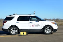
TTI uses an instrumented vehicle equipped with cameras and other sensors to drive the test route.
What it is and what it means
TTI is conducting the research at the RELLIS campus, a 2,000-acre facility where specialized research can be conducted without interfering with traffic on the open road or exposing personnel to the risk of working in an uncontrolled environment. At the RELLIS campus, TTI works with pavement-marking companies to design and install a range of pavement markings that represent a range in performance from almost new to marginal to inadequate (in terms of both daytime and nighttime conditions).
Once the pavement markings are installed, their performance is characterized using traditional highway metrics such as 30-m retro-reflectivity, but also new and innovative metrics that may better align with machine-vision performance.
TTI uses an instrumented vehicle equipped with cameras and other vehicle sensors to drive the test route with the experimental markings. The researchers measure and collect camera-detection ratings for the different markings. Data collection occurs under a variety of conditions including daytime dry, daytime wet, nighttime dry, nighttime wet, and nighttime day and wet with and without continuous roadway lighting.
While the research is still underway and findings are being analyzed and qualified, one of the early findings is that nighttime detection is generally easier than daytime detection. In addition, wet conditions also are proving tough for the cameras, in both day and night. The research is considering white and yellow pavement markings in both continuous edge-line scenarios as well as lane-line scenarios (also known as skip lines). The research also has considered the impact of continuous roadway lighting in both dry and wet nighttime conditions.
Specifics on the results of these analyses will be available by the end of summer 2017, when the draft recommendations are due. If the initial results hold true throughout the remainder of the research period, there could be a shift from the nighttime-centric metrics currently used to assess pavement markings to a more balanced approach that includes metrics designed for both daytime and nighttime performance.
The research team is exploring how the traditional pavement-marking metrics such as daytime color and 30-m retroreflectivity correlate to camera performance. But there also is a need to explore how new metrics may better correlate with camera performance. To do that, the research team has worked with industry experts to develop new ways to assess pavement markings. The feasibility of using any new metric to assess pavement markings will be thoroughly vetted with state and local transportation agencies.
All of the testing is currently being conducted with 4-in.-wide pavement-marking materials. A follow-up study is already on the books to determine the impacts of 6-in.-wide pavement markings, which have already been shown to reduce crashes on two-lane highways. Additional testing will be needed to address other pavement-marking issues. For instance, the research is not specifically addressing how contrast markings (markings enhanced with black borders or black tails) can enhance camera detection. In addition, there is an interest to further test structured pavement markings, wet-weather pavement markings and pavementmarking eradication techniques.
A joint task force made up of Society of Automotive Engineers (SAE) and American Association of State Highway & Transportation Officials (AASHTO) members is standing by, ready to develop a specification based on the research findings. The joint SAE/AASHTO specification is intended to provide a base performance level that state and local DOTs can use, if they choose, to maintain roadways to a level of readiness for AVT that rely on consistent pavement-marking detection.
TTI has a 65-year history of providing practical solutions for state and local DOTs, and this research is no different. For the past few years, automotive industry representatives have made plain that they need well-maintained markings for their vehicle technologies, but unfortunately have not provided a clear meaning of what they actually need. This is perhaps indicative of the relatively early development and adaption status of these technologies. At the same time, state and local DOTs have been asking what they need to do to be ready for AVTs. The findings that TTI is developing will address these needs for both industries. In many ways, this research is the beginning of a new era in the transportation arena where specific assets on and along the highway may need to be designed, specified and maintained to accommodate two types of drivers—humans and machines, operating in what will hopefully be harmony with one another. There may be a future where roads are classified by their readiness in terms of AVT needs. Pavement markings clearly will be part of that road readiness form.
All of the testing at TTI is being conducted with 4-in.-wide pavement markings.
Staying safe
Connected and automated vehicles (CAV) are coming, and are expected to transform the transportation industry. Expectations are that CAVs will significantly reduce crashes, improve mobility and eventually transform how we view and utilize transportation in general.
Undoubtedly, CAVs have a significant influence on how future work zones will be designed, implemented and operated in the future. However, exactly how CAVs will impact work zones remains to be seen. CAV operations offer opportunities to reduce many of the problems and issues that work zones currently create. At the same time, the way that work zones are designed, implemented and operated create significant challenges for CAV developers. Many of these challenges are technical in nature. However, institutional and legal challenges also will need to be identified and addressed to make CAV operations in work zones a reality.
In 2015, a total of 701 fatalities and over 35,000 injuries occurred at work zones in the U.S. and Puerto Rico. It is a generally accepted fact that crash risk increases significantly in and around work zones. Because work zones are various, in direct correlation to the variety of road and bridge construction projects, there are myriad aspects of work zones in general that can produce specific safety concerns, but also there are a few aspects that can be considered constants across the board. Work zones reduce lateral recovery areas, introduce disruptions (often unexpected) into the traffic stream and often require changes to normal travel paths. Drivers often fail to recognize or acknowledge the existence of these degraded operating conditions and adjust their behavior accordingly, leading to the increased frequency of crashes.
Fortunately, a number of national CAV applications are under development that could significantly reduce many work-zone crashes. Initially, these applications will connect vehicles with each other and with roadside devices. Using dedicated short-range communication (DSRC), these applications will provide motorists with alerts and warnings to help them better react to specific work-zone conditions and hazards. Eventually, these reactions would be taken over by the vehicle automatically, further eliminating driver error and improving safety. Four CAV applications in particular have significant work-zone safety improvement potential:
Reduced speed/work-zone warning: This application involves the detection of a reduced speed limit and/or lane closure in a work zone and issuing an in-vehicle alert to the driver to slow down, change lanes or stop.
Queue warning: As the title implies, this application involves the detection of current or impending queues downstream and issuing an in-vehicle warning to the driver or vehicle. The presence of a queue could be identified and communicated from other vehicles downstream who have encountered the queue, or from roadside units that are connected to other queue detection sources along the corridor (such as traditional traffic surveillance and monitoring systems).
Dynamic speed harmonization: This application involves the detection of speed changes and provision of a recommended speed to drivers (or directly to the vehicle) based on data received about downstream operating conditions. The intent is to reduce speed variation and turbulence in the traffic stream by smoothly adjusting speeds of vehicles in locations where lanes are narrower and/or work activities are occurring very close to the travel lanes.
Work-zone traveler information: This application is envisioned as the data warehouse regarding information about current and upcoming work zones in terms of location, hours of operation, lane closure or travel path changes, speed limits and so forth. This application would provide critical information to the other applications, as well as navigational services that would reroute vehicles to completely avoid the work zone and any congestion created. The application also could be beneficial to agencies for work-zone performance monitoring where accurate location and real-time traffic-control conditions are needed to be matched with safety and operational data.
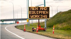
A challenge for CAVs is interacting with potentially complicated traffic-control signage in work zones.
CAV challenges in work zones
While there are potentially significant benefits to be gained through the implementation of CAV technology in work zones, the fact of the matter is that work zones themselves present substantial challenges to CAV developers. Many of these are technical in nature. By necessity, work-zone traffic-control designs are generally site-specific. Ideally, CAV developers would prefer all work zones to be laid out and function individually but identically in all situations. However, depending on the needs of the work tasks to be accomplished within the work zone, complicated traffic-control signing and channelization may be required. A densely urban interchange with multiple access points and multi-directional traffic flow is going to be handled much differently than a rural work zone that must manage a corridor of two-way traffic that sees only 1,000 vehicles per day. Envisioning and interpreting all the ways in which traffic can be accommodated through a work zone is extremely challenging for those who are developing computer algorithms to operate CAV systems.
In addition to the myriad ways in which traffic might need to be accommodated through a work zone, ensuring the implementation of work-zone traffic control designed to be of high-enough quality for CAVs is another significant challenge. Mundane activities such as eradicating old pavement markings well enough to ensure that the new temporary markings are properly interpreted by human drivers has plagued agencies and contractors for many years. This undoubtedly will be an even bigger challenge for CAV operations. Improper advance-warning sign installation and placement that occasionally occurs in work zones also can create significant challenges for CAVs.
Finally, there will exist formidable institutional challenges to CAV operations in work zones. Unlike normal roadway operations in which sole responsibility lies with the owner agencies, responsibility for how a work-zone location is established and maintained is typically shared with the contractor who is performing the actual road work. Current business processes for work zones have evolved over the past 50 years toward a primarily project-delivery-based focus. Temporary traffic-control needs and accommodation, while important to both parties, have been viewed strictly as a means to meeting this project delivery goal. It has not been extremely important to know precisely when and where all temporary traffic-control actions that can affect travel paths have been implemented or when they have been removed on a minute-by-minute or even second-by-second basis, nor has it been necessary to communicate this information digitally nearly instantaneously. However, that level of precision and responsiveness will likely be needed in the future to safely support CAV operations. Methods of validating that temporary traffic control is sufficient to accommodate CAVs will be needed, as will methods of ensuring that the control is being sufficiently maintained over time. This undoubtedly will require new bid specifications, testing methods, contracting arrangements and other business processes.
---------------
Carlson is a senior research engineer with the Texas A&M Transportation Institute. Ullman is a senior research engineer and Regents Fellow at the Texas A&M Transportation Institute.


